Sunamganj District
| third-level administrative division
Bangladesh /
Sunamganj /
World
/ Bangladesh
/ Sunamganj
/ Sunamganj
World / Bangladesh / Sylhet / Sylhet / Sun Amgonj
district, invisible, third-level administrative division


Sunamganj District (Sylhet division) with an area of 3669.58 sq km, is bounded by Khasia and Jaintia hills (India) on the north, Habiganj and Kishoreganj districts on the south, Sylhet district on the east, Netrokona and greater Mymensingh districts on the west. Annual average temperature: maximum 33.2°C and minimum 13.6°C; annual rainfall 3334 mm. There are many haors and beels in Sunamganj.
The geographic coordinates of Sunamganj town centre are 25.0663438N 91.394856E. Sunamganj (Town) stands on the bank of the river Surma. It was established in late 18th century. It consists of 9 wards and 44 mahallas. The town has an area of 22.16 sq km. It has a population of 49373; male 52.70%, female 47.30%; density of population is 2228 per sq km. Literacy rate among the town people is 58.8%. The town has five dakbungalows.
Sunamganj mahakuma (sub-division) was upgraded to a district in 1984. This district consists of 10 upazilas, 4 municipalities, 36 wards, 139 mahallas, 82 union parishads, 1711 mouzas and 2813 villages. The upazilas are bishwamvarpur, chhatak, derai, dharmapasha, dowarabazar, jagannathpur, jamalganj, tahirpur, sullah and sunamganj sadar.
Archaeological heritage: Bagbari Tila (Chhatak upazila), Selbarash Jami Mosque, Sukhair Kalibari Temple, Kahala Kalibari, Maheshkhala Kalibari (Dharmapasha upazila), remnants of the palace of Raja Bijoy Singh (16th century, Tahirpur upazila).
In 1336 BS a devastating flood occurred as a result of breaking down a damn in Manipur. This flood is popularly known as 'White Water Flood'. A pernicious earthquake on 12 June 1897 caused heavy loss of lives and establishments.
As of 1991 Bangladesh census, Population 1968669; male 50.89%, female 49.11%; Muslim 83.62%, Hindu 15.95%, others 0.43% ethnic nationals 6,643 (Manipuri, Khasia, Garo and Hajong).
Religious institutions: Palash Jami Mosque (Bishwamvarpur upazila), Makhraj Mosque, tomb of Baba Shah, Maddianagar Mosque, Selbarash Jami Mosque, Dharmapasha Jami Mosque, tomb of Nangta Pir, Kahala Kalibari, Maheshkhala Kali Mandir, Sukhair Kali Mandir (Dharmapasha upazila), Ikardai Jami Mosque, Vasudev Mandir (Jagannathpur upazila), Sreehail Sabbari Jami Mosque, Ramkrishna Gosai Akhra (1750), Bahra Sumeshwari Mandir (Sullah upazila), Pagla Jami Mosque, Patharia Baishnab Akhra (Sunamganj Sadar upazila), Tahirpur Jami Mosque, Badamghata Jami Mosque, mazar of Shah Arifin Saheb are notable.
Literacy and educational institutions: Average literacy 22.3%; male 27.5%, female 17.6%. Educational institutions: college 22, secondary school 126, primary school (government) 664, primary school (private) 312, madrasa 104, satellite school 94, community school 56, technical institute 2, PTI 1, music school 5.
Cultural organisations: Club 10, rural club 363, public library 10, cinema hall 13, cultural organisation (theatre and music) 38, theatre stage 4, jatra party 4, literary society 7, women's organisation 113, Shilpakala Academy 1, Shishu Academy 1, playground 58, stadium 1.
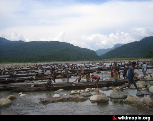
Main occupations: Agriculture 43.43%, fishing 3.34%, agricultural labourer 24.10%, wage labourer 5.58%, commerce 7.44%, service 3.8%, others 12.31%.
Land use: Arable land 294021 hectares, fallow land 51752 hectares.
Land control: Among the peasants, 33% are landless, 26% small, 21% intermediate and 20% rich.
Fisheries, dairies, poultries Fishery 604, dairy 105, poultry 697, hatchery 6.
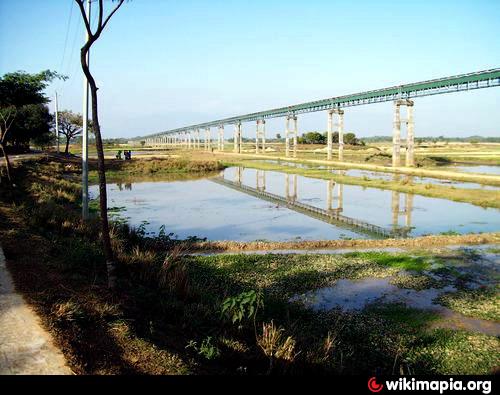
Communication facilities- Roads: pucca 150 km, semi pucca 52 km and mud road 2279 km; railways 20 km; waterways 98 nautical mile.
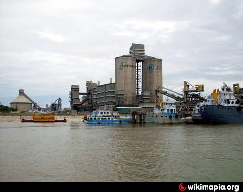
Manufactories: Chhatak Cement Factory (1940), Chhatak Pulp and Paper Mills (1959) are most notable; other manufactories include flour mill, ice factory, rice mill, saw mill, cold storage and fish processing, printing presses.
Cottage industries: Weaving. goldsmith, blacksmith, potteries, bamboo & cane work, pearl work, tailoring, welding.
Mineral resources: Natural gas, limestone and stone.
NGO activities: brac, grameen bank, asa, proshika, Shova, Masjid Mission, BARD, Shawnirvar Bangladesh, BAOPA, CNRS, Vision 2000, CARE, HEED Bangladesh.
Health centres: Upazila health centre 8, hospital (government and private) 23, health & family welfare centre 6, family planning centre 31, satellite clinic 9, charitable dispensary 15. TB clinic 2 (operated by BRAC) and leprosy treatment centre 2 (operated by HEED Bangladesh).
The name Sunamganj is derived from its founder, Sipahi Sunamuddin, who established a bazaar on the bank of the river Surma. In the ancient period, Sunamganj was part of the Rarh Kingdom that included western part of Sylhet, Habiganj, Netrokona, Kishoreganj and the northern part of Mymensingh. After the conquest of Sylhet in 1303 by Muslims under the spiritual guidance of Hazrat Shah Jalal, Hazrat Shah Kamal Qahafan brought the entire Kingdom of Rarh under his control with aid of his twelve disciples and Shah Moazzamuddin, administered the entire district from Shaharpara. Between the latter part of 1300 CE and 1765 CE, the present-day Sunamganj district was a part of Iqlim-e-Moazzamabad, i.e. the state of Moazzamabad, which was independent state until 1612 and, thereafter, it was conquered by the mighty Mughal of Delhi.
Sunamganj is renowned for bards and folk music; mystic poet Hason Raja (1854CE-1922CE), Saifa Banu (1860-1926), Diwan Moshin Raja, Syed Shahnoor, Radharaman Dutta, Radhamadhav Dutta, Doorbin Shah, Shah Abdul Karim, Muniruzzaman Munir, Nurul Ghani, Dilly Meah, Qari Amiruddin and many more have hailed from this area.
It must be underlined that Saifa Banu (1860-1926) is regarded as the first female poet of Bangladesh; she was a step-sister of the mystic poet Hasan Raja, and composed lyrics in Bengali, Urdu and Hindi. Local people called her ‘Haji Bibi’ as a mark of respect, following her pilgrimage to Mecca, and she was entrusted to resolve civil disputes as an arbitrator. She was married to ‘Abdul Wahid’, alias Hiran Miah, whose mental incapacity compelled Saifa to extend her responsibility beyond domestic chores, which rather challenging those days.
The geographic coordinates of Sunamganj town centre are 25.0663438N 91.394856E. Sunamganj (Town) stands on the bank of the river Surma. It was established in late 18th century. It consists of 9 wards and 44 mahallas. The town has an area of 22.16 sq km. It has a population of 49373; male 52.70%, female 47.30%; density of population is 2228 per sq km. Literacy rate among the town people is 58.8%. The town has five dakbungalows.
Sunamganj mahakuma (sub-division) was upgraded to a district in 1984. This district consists of 10 upazilas, 4 municipalities, 36 wards, 139 mahallas, 82 union parishads, 1711 mouzas and 2813 villages. The upazilas are bishwamvarpur, chhatak, derai, dharmapasha, dowarabazar, jagannathpur, jamalganj, tahirpur, sullah and sunamganj sadar.
Archaeological heritage: Bagbari Tila (Chhatak upazila), Selbarash Jami Mosque, Sukhair Kalibari Temple, Kahala Kalibari, Maheshkhala Kalibari (Dharmapasha upazila), remnants of the palace of Raja Bijoy Singh (16th century, Tahirpur upazila).
In 1336 BS a devastating flood occurred as a result of breaking down a damn in Manipur. This flood is popularly known as 'White Water Flood'. A pernicious earthquake on 12 June 1897 caused heavy loss of lives and establishments.
As of 1991 Bangladesh census, Population 1968669; male 50.89%, female 49.11%; Muslim 83.62%, Hindu 15.95%, others 0.43% ethnic nationals 6,643 (Manipuri, Khasia, Garo and Hajong).
Religious institutions: Palash Jami Mosque (Bishwamvarpur upazila), Makhraj Mosque, tomb of Baba Shah, Maddianagar Mosque, Selbarash Jami Mosque, Dharmapasha Jami Mosque, tomb of Nangta Pir, Kahala Kalibari, Maheshkhala Kali Mandir, Sukhair Kali Mandir (Dharmapasha upazila), Ikardai Jami Mosque, Vasudev Mandir (Jagannathpur upazila), Sreehail Sabbari Jami Mosque, Ramkrishna Gosai Akhra (1750), Bahra Sumeshwari Mandir (Sullah upazila), Pagla Jami Mosque, Patharia Baishnab Akhra (Sunamganj Sadar upazila), Tahirpur Jami Mosque, Badamghata Jami Mosque, mazar of Shah Arifin Saheb are notable.
Literacy and educational institutions: Average literacy 22.3%; male 27.5%, female 17.6%. Educational institutions: college 22, secondary school 126, primary school (government) 664, primary school (private) 312, madrasa 104, satellite school 94, community school 56, technical institute 2, PTI 1, music school 5.
Cultural organisations: Club 10, rural club 363, public library 10, cinema hall 13, cultural organisation (theatre and music) 38, theatre stage 4, jatra party 4, literary society 7, women's organisation 113, Shilpakala Academy 1, Shishu Academy 1, playground 58, stadium 1.
Main occupations: Agriculture 43.43%, fishing 3.34%, agricultural labourer 24.10%, wage labourer 5.58%, commerce 7.44%, service 3.8%, others 12.31%.
Land use: Arable land 294021 hectares, fallow land 51752 hectares.
Land control: Among the peasants, 33% are landless, 26% small, 21% intermediate and 20% rich.
Fisheries, dairies, poultries Fishery 604, dairy 105, poultry 697, hatchery 6.
Communication facilities- Roads: pucca 150 km, semi pucca 52 km and mud road 2279 km; railways 20 km; waterways 98 nautical mile.
Manufactories: Chhatak Cement Factory (1940), Chhatak Pulp and Paper Mills (1959) are most notable; other manufactories include flour mill, ice factory, rice mill, saw mill, cold storage and fish processing, printing presses.
Cottage industries: Weaving. goldsmith, blacksmith, potteries, bamboo & cane work, pearl work, tailoring, welding.
Mineral resources: Natural gas, limestone and stone.
NGO activities: brac, grameen bank, asa, proshika, Shova, Masjid Mission, BARD, Shawnirvar Bangladesh, BAOPA, CNRS, Vision 2000, CARE, HEED Bangladesh.
Health centres: Upazila health centre 8, hospital (government and private) 23, health & family welfare centre 6, family planning centre 31, satellite clinic 9, charitable dispensary 15. TB clinic 2 (operated by BRAC) and leprosy treatment centre 2 (operated by HEED Bangladesh).
The name Sunamganj is derived from its founder, Sipahi Sunamuddin, who established a bazaar on the bank of the river Surma. In the ancient period, Sunamganj was part of the Rarh Kingdom that included western part of Sylhet, Habiganj, Netrokona, Kishoreganj and the northern part of Mymensingh. After the conquest of Sylhet in 1303 by Muslims under the spiritual guidance of Hazrat Shah Jalal, Hazrat Shah Kamal Qahafan brought the entire Kingdom of Rarh under his control with aid of his twelve disciples and Shah Moazzamuddin, administered the entire district from Shaharpara. Between the latter part of 1300 CE and 1765 CE, the present-day Sunamganj district was a part of Iqlim-e-Moazzamabad, i.e. the state of Moazzamabad, which was independent state until 1612 and, thereafter, it was conquered by the mighty Mughal of Delhi.
Sunamganj is renowned for bards and folk music; mystic poet Hason Raja (1854CE-1922CE), Saifa Banu (1860-1926), Diwan Moshin Raja, Syed Shahnoor, Radharaman Dutta, Radhamadhav Dutta, Doorbin Shah, Shah Abdul Karim, Muniruzzaman Munir, Nurul Ghani, Dilly Meah, Qari Amiruddin and many more have hailed from this area.
It must be underlined that Saifa Banu (1860-1926) is regarded as the first female poet of Bangladesh; she was a step-sister of the mystic poet Hasan Raja, and composed lyrics in Bengali, Urdu and Hindi. Local people called her ‘Haji Bibi’ as a mark of respect, following her pilgrimage to Mecca, and she was entrusted to resolve civil disputes as an arbitrator. She was married to ‘Abdul Wahid’, alias Hiran Miah, whose mental incapacity compelled Saifa to extend her responsibility beyond domestic chores, which rather challenging those days.
Wikipedia article: http://en.wikipedia.org/wiki/Sunamganj_District
Nearby cities:
Coordinates: 24°55'38"N 91°20'10"E
- Habigonj District 24 km
- Maulvibazar District 32 km
- Sylhet District 41 km
- Khagrachari District 139 km
- Rangamati District 150 km
- Noakhali District 215 km
- Chattogram District Area 217 km
- Bhola District 260 km
- Lhuentse Dzongkhag 354 km
- District Upper Siang (AP) 569 km
- Dekar haor 14 km
- Dharmapasa Upazila 29 km
- Khaliajuri Upazila 30 km
- dingasuta Haor 33 km
- Tanguar Haor (wetland) Complex 34 km
- Mohangonj Upazila 34 km
- Tanguar haor 36 km
- Sylhet Division 55 km
- Meghalaya 68 km
- Dhaka Division 133 km
Comments