Hawaii Tracking Station (HTS), HULA
USA /
Hawaii /
Makaha Valley /
World
/ USA
/ Hawaii
/ Makaha Valley
World / United States / Hawaii
military
Add category
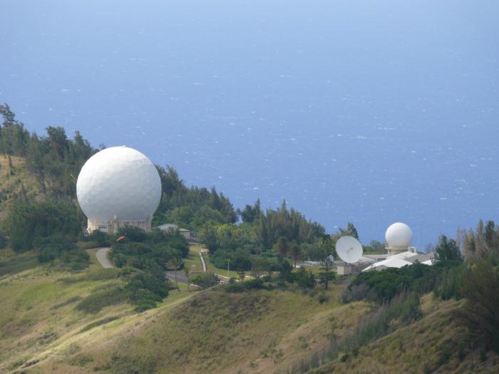
This is the communications center. One of eight Remote Tracking Stations (RTS) maintained by the Air Force Satellite Control Network (AFSCN).
Detachment 4, 22d Space Operations Squadron, part of the 50th Space Wing, operates Hawaii Tracking Station (HTS, callsign HULA) on the site. It was constructed in 1959, one of three built that year. The facility is placed on the western-most point of the island of Oahu, atop a 1500 foot high ridge. Originally, the facility only had one large, exposed antenna. Today it has many smaller radomes and access roads up and around the ridge.
It supports ballistic missile testing conducted from Vandenberg Air Force Base and other areas in the Pacific. It also provides onorbit support for low earth orbiting satellites and geosynchronous satellite over the eastern and central Pacific.
Wikipedia article: http://en.wikipedia.org/wiki/Kaena_Point_Satellite_Tracking_Station
Nearby cities:
Coordinates: 21°33'39"N 158°14'20"W
- Makua Military Reservation 1.4 km
- Schofield Barracks Military Reservation 10 km
- Naval Magazine Pearl Harbor (a.k.a. Naval Magazine Lualualei) 13 km
- Kawailoa Military Training Area 22 km
- East Range Military Training Area 23 km
- Ewa Forest Reserve - Poamoho Section/Poamoho Training Area 25 km
- Former Naval Air Station Barbers Point 30 km
- Pearl Harbor 32 km
- Joint Base Pearl Harbor – Hickam (IATA: HIK – ICAO: PHIK) 35 km
- Fort Shafter 41 km
- Kuaokalā Game Management Area 0.5 km
- Ka'ena Point State Park 1.3 km
- Dillingham Airfield 4.6 km
- Dillingham Ranch 5.4 km
- Makua Keaau Forest Reserve 7.5 km
- Mokulēʻia Forest Reserve 8.1 km
- Makaha Golf Club West 10 km
- Oʻahu 30 km
- Wai'anae Slump 43 km
- Kaʻieʻie Waho Channel 56 km