Muktagacha Upazila HQ.
Bangladesh /
Maimansingh /
Muktagachha /
World
/ Bangladesh
/ Maimansingh
/ Muktagachha
World / Bangladesh / Dhaka / Mymensingh / Nasirabad
township, subdistrict, fourth-level administrative division, local government
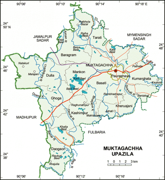
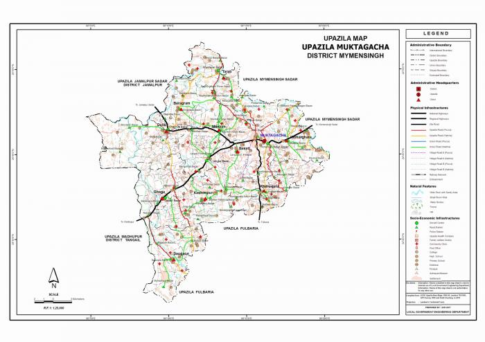
Muktagachha Upazila (Mymensingh district) with an area of 314.71 sq km, is bounded by Mymensingh sadar and Jamalpur sadar upazilas on the north, Fulbaria upazila on the south, Mymensingh sadar and Fulbaria upazilas on the east, Madhupur and Jamalpur sadar upazilas on the west. Main rivers are Aiman, Sirkhali and Sutia; noted depressions are Baril, Haoda, Raiha, Khalia, Daria Chital Beels; forestry 1252 hectares.
Muktagachha (Town) consists 9 wards and 20 mahallas. The area of the town is 7.28 sq km. It is an old municipal town (established in 1875). It has a population of 37043; male 50.63% and female 49.37%; density of population per sq km is 5088. Literacy rate among the town people is 45.93%.
Administration Muktagachha thana was established in 1961 and was turned into an upazila in 1983. The upazila consists of 1 municipality, 9 wards, 20 mahallas, 10 union parishads, 261 mouzas and 273 villages.
Archaeological relics and monuments Gopal and Shiva Mandir at the Atani Zamindar Bari (eighteenth century), Anandamoyee Kali and Shiva Mondir, Lakshmikhola Shiva Mandir, Kutub Shah Mazar (tomb) at Kutubpur and Joyen Shah Mazar at Rasulpur.
Religious institutions Mosque 428, temple 28, church 3 and tomb 5.
As of 1991 Bangladesh census, population 321759; 50.77% male and 49.23% female; Muslim 94.34%, Hindu 5.35%, Christian 0.21%, and others 0.23%.
Literacy and educational institutions Average literacy 22.90%. Educational institutions: government college 1, non-government college 3, high school 40, madrasa 18, government primary school 101, non-government primary school 43. Noted old Educational institutions: Ramkishore High School (1300 BH) and Nagendra Narayan Primary School (1907).
Main occupations Agriculture 47.71%, agricultural labourer 22.76%, wage labourer 2.82%, commerce 8.3%, service 3.59%, others 14.82%.
Land control Among the peasants, 22% are landless, 47% small, 29% intermediate and 2% rich.
Fisheries, dairies, poultries Fishery 103, dairy 27, poultry 61.
Communication facilities Roads: pucca 38.50 km, semi pucca 11 km and mud road 310 km.
Manufactories Biscuit factory 15, oil mill 12, press 3, saw mill 16, rice mill 221 and bidi factory 2.
Cottage industries Weaving 126, bamboo and cane work 30, blacksmith 72, wood work 40, diary products (ghee) 25.
NGO activities Operationally important NGOs are brac, grameen bank, proshika, caritas, asa, SDP, Atta Karma Juba Unnayan, Pratasha and SDS.
Health centres Upazila health complex 1, satellite clinic 4 and family welfare centre 6 and veterinary hospital 1.
Nearby cities:
Coordinates: 24°45'50"N 90°15'27"E
- Gafargaon Upazila 32 km
- Dhobaura Upazila 49 km
- Kapashia Upazila 60 km
- Rupganj Upazila 95 km
- Keraniganj Upazila 113 km
- Lohajang Upazila 136 km
- Matlab Upazila (North) Area 144 km
- Patiya Upazila (পটিয়া) 311 km
- Chandanaish Upazila 326 km
- Banshkhali Upazila (বাঁশখালী উপজেলা) 330 km
- lake 8.4 km
- BAZAAR 10 km
- Shopir Tilla / Gorostan 11 km
- Modho Kona Para 11 km
- Bharuakhali 15 km
- BAZAAR 22 km
- Madhupur Tract 25 km
- rrrrrrrrrr 27 km
- Alokdia High School 32 km
- Dhaka Division 70 km