Sarishabari Upazila HQ
Bangladesh /
Jamalpur /
Sarishabari /
World
/ Bangladesh
/ Jamalpur
/ Sarishabari
World / Bangladesh / Dhaka / Jamalpur / Jamalpur
fourth-level administrative division
Add category

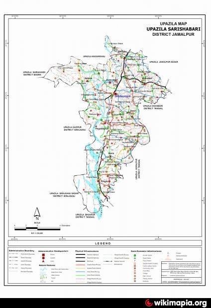
Sarishabari Upazila of Jamalpur district with an area of 263.48 sq km, is bounded by madarganj and jamalpur sadar upazilas on the north, Bhuapur upazila on the south, Gopalpur and Madhupur upazilas on the east, Sariakandi, Kazipur and Sirajganj sadar upazilas on the west. Main rivers are jamuna, Jhinai and Shishua; depressions 11 most noted of which are Kathakhal, Taltala and Hasba beels.
Sarishabari is located at 24.7417°N 89.8333°E. It has 58,254 households. Sarishabari (Town) a municipal town, consists of 9 wards and 35 mahallas. The area of town is 23.60 sq km. The town has a population of 52639; male 51.42%, female 48.58%. Population density per sq km is 2230. Literacy rate among the town people is 35.9%.
Sarishabari thana, now an upazila, was established in 1960. The upazila consists of one municipality, 9 wards, 8 union parishads, 138 mouzas and 179 villages.
Archaeological heritage and relics Five domed Raspal Jami Mosque (nineteenth century), Narapara Fort (sixteenth century).
As of 1991 Bangladesh census, Population 289106; male 51.66%, female 48.34%; Muslim 96.56%, Hindu 3.11%, Christian 0.16%, Buddhist 0.03% and others 0.14%; ethnic garo and hajong 108 families.
Religious institutions: Mosque 530, temple 12.
Average literacy 24.1%; male 29.5% and female 18.7%. Educational institutions: college 7, secondary school 36, madrasa 27, government primary school 85 and non-government primary school 54; noted old educational institutions: Pingna Madrasa (Emperor Shahjahan's period), Pingna English High School (1896), Balaridia Primary School (1869), Sarishabari Nidmani High school (1920), Pogaldia Primary School (1890).
Main occupations Agriculture 46.88%, agricultural labourer 20.56%, wage labourer 2.64%, commerce 10.59%, service 7.64% and others 11.69%.
Land use Total cultivable land 18161.88 hectares, fallow land 4441.52 hectares.
Land control Among the peasants, 26.30% are landless, 27.12% marginal, 34.68% small, 10.36% intermediate and 1.54% rich
Communication facilities Roads: pucca 80 km, semi pucca 75 km and mud road 300 km; railways 17 km; waterways 16 nautical mile.
Fisheries, dairies, poultries Dairy 5, cattle breeding centre 4, poultry 15, hatchery 3.
Manufactories Jute mill 3, fertiliser factory 1, welding 40.
Cottage industries Weaving 1067, blacksmiths 52, potteries 64, goldsmith 48, bamboo and cane work 146, tailoring 130, wood worker 130, jute and cotton 8.
Health centres Upazila health complex 1, satellite clinic 3, family planning centre 8.
NGO activities Operationally important NGOs are brac, asa, grameen bank, CARE, caritas, buro tangail, DANIDA and SDS.
Nearby cities:
Coordinates: 24°45'20"N 89°50'7"E
- Sarishabari Upazila 14 km
- Shaghatta Upazila 65 km
- Gobindaganj Upazila 83 km
- Bholahat Upazila HQ 168 km
- Abhaynagar Upazila HQ 194 km
- Fakirhat Upazila HQ 218 km
- Kachua Upazila HQ 232 km
- Koyra Upzila HQ 270 km
- Maidi Vdc 618 km
- Samote Union Council 1859 km
- Murad hassan 3.9 km
- Jamuna Fertilizer Company Limited (JFCL) 8.4 km
- JFCL Colony 9 km
- kabariabari villege 13 km
- Dhanbari Palace (Nawab-bari) 15 km
- pingna 16 km
- Charsimla By bulbul 01712570736 19 km
- Madhupur Tract 37 km
- Dhaka Division 86 km
- Rajshahi Division 103 km