Adding places/ru
(→Название) |
Viflyantsev (Talk | contribs) (→Категории) |
||
| (7 intermediate revisions by one user not shown) | |||
| Line 1: | Line 1: | ||
{{Languages|Adding_places}} | {{Languages|Adding_places}} | ||
| − | |||
Добавить объект легко — в главном меню «Редактирование» выберите пункт «Добавить объект» из выпадающего меню (или просто нажмите на находящуюся в левом верхнем углу кнопку «Добавить объект») и в нижней части экрана появится соответствующий инструмент. Ниже вы можете прочитать как сделать правильный контур-многоугольник. | Добавить объект легко — в главном меню «Редактирование» выберите пункт «Добавить объект» из выпадающего меню (или просто нажмите на находящуюся в левом верхнем углу кнопку «Добавить объект») и в нижней части экрана появится соответствующий инструмент. Ниже вы можете прочитать как сделать правильный контур-многоугольник. | ||
| Line 33: | Line 32: | ||
==Название== | ==Название== | ||
| − | Желательно написать название создаваемого объекта. Написанное название должно быть официальным. Если же официальное название неизвестно или отсутствует, то | + | Желательно написать название создаваемого объекта. Написанное название должно быть официальным. Если же официальное название неизвестно или отсутствует, то надо написать народное или широко используемое название, но в таком случае необходимо сделать примечание в [http://wikimapia.org/docs/Adding_places/ru#.D0.9E.D0.BF.D0.B8.D1.81.D0.B0.D0.BD.D0.B8.D0.B5 «Описании»], что это неофициальное название. Любая другая информация, не являющаяся названием, — почтовый индекс, дополнительные сведения о месторасположении — должна быть написана в описании объекта. |
| − | + | Помните, что это название будет отображаться при наведении курсора мыши на контур и, поэтому, в нём не должно быть лишней информации. Запрещено писать в названии имя пользователя и/или его ник, а так же номер телефона. | |
| − | + | Если вы хотите написать сокращённое название, то это должно быть официальной аббревиатурой, а не неофициальной, которую вы придумали для «экономии места». Название, состоящее из небольшого количества слов, должно быть написано полностью (без сокращений). | |
| − | + | ||
| − | + | ||
| − | Если вы хотите написать сокращённое название, то | + | |
Следует избегать писать текст с [http://ru.wikipedia.org/wiki/%D0%9C%D0%B0%D1%8E%D1%81%D0%BA%D1%83%D0%BB использованием "CAPS LOCK"]. Помимо того, что это форма вэб-сленга для ''крика'', такой текст визуально смотрится хуже надписи, состоящей из прописных и строчных букв. | Следует избегать писать текст с [http://ru.wikipedia.org/wiki/%D0%9C%D0%B0%D1%8E%D1%81%D0%BA%D1%83%D0%BB использованием "CAPS LOCK"]. Помимо того, что это форма вэб-сленга для ''крика'', такой текст визуально смотрится хуже надписи, состоящей из прописных и строчных букв. | ||
| + | |||
| + | Если у объекта имеется адрес, то его можно использовать вместо названия. В зависимости от места расположения объекта, имеется два варианта для достижения этого: | ||
| + | |||
| + | #Если объект расположен в стране, где используется формат 'номер дома > улица', вы можете использовать адрес (например: 234 Sycamore Avenue), написав его в качестве названия. Помните, что вы всё-равно должны добавить эту информацию в специальном разделе [http://wikimapia.org/docs/%D0%94%D0%BE%D0%B1%D0%B0%D0%B2%D0%BB%D0%B5%D0%BD%D0%B8%D0%B5_%D0%BE%D0%B1%D1%8A%D0%B5%D0%BA%D1%82%D0%B0#.D0.90.D0.B4.D1.80.D0.B5.D1.81 «Адрес»]. | ||
| + | #Если объект расположен в стране, которая использует формат адреса, представленный в Wikimapia (то есть: улица > номер дома), вы должны оставить строку названия объекта пустой. Wikimapia автоматически присвоит название объекту (будет указан адрес) на основании информации из [http://wikimapia.org/docs/%D0%94%D0%BE%D0%B1%D0%B0%D0%B2%D0%BB%D0%B5%D0%BD%D0%B8%D0%B5_%D0%BE%D0%B1%D1%8A%D0%B5%D0%BA%D1%82%D0%B0#.D0.90.D0.B4.D1.80.D0.B5.D1.81 адресной] строки. Этот формат используется в России (Wikimapia основана в России) и некоторых других странах. | ||
==Описание== | ==Описание== | ||
| Line 99: | Line 100: | ||
==Категории== | ==Категории== | ||
| − | |||
| − | + | Категории - это метки, которые позволяют классифицировать объект согласно его типа или функции. Объект должен иметь по крайней мере <u>одну</u> категорию, что особенно необходимо для поиска отдельных объектов через инструмент поиска по категории. Также категории обогащают объект визуально, поскольку показывают иконки и/или различные цвета многоугольников. Последнее можно видеть исключительно в режиме просмотра "Карта". | |
| + | |||
| + | |||
| + | При выборе категории открывается список наиболее часто употребляемых категорий. Если нужной категории не находится при прокручивании списка вниз, используйте окно поска, чтобы найти её. Не следует присваивать слишком много категорий, в большинстве случаев вполне достаточно одной. | ||
| − | + | Важно помнить две вещи: никогда не используйте комбинацию двух или нескольких категорий для обозначения одной. Во-вторых, следует использовать только наиболее подходящую категорию, которая описывает нынешнюю функцию создаваемого Вами объекта. Не добавляйте как внешние категории, использованные для вложенных объектов, которые находятся в основном, если они сами по себе могут быть представлены как объекты. Например, если Вы отмечаете торговый центр, Вы должны использовать только категорию [http://old.wikimapia.org/#lat=48.8309261&lon=15.0906254&z=2&l=37&m=b&tag=2657&show=/object/category/?type=view&id=2657&lng=1&tab=main торговый центр]. Не используйте категории вложенных объектов, которые привязаны к торговому центру, поскольку торговый центр является торговым центром и только. | |
==This place is a building== | ==This place is a building== | ||
Latest revision as of 23:58, 18 February 2014
| Language: | English • Português • Русский |
|---|
Добавить объект легко — в главном меню «Редактирование» выберите пункт «Добавить объект» из выпадающего меню (или просто нажмите на находящуюся в левом верхнем углу кнопку «Добавить объект») и в нижней части экрана появится соответствующий инструмент. Ниже вы можете прочитать как сделать правильный контур-многоугольник.
Contents |
[edit] Контур
Контур — многоугольник, при помощи которого определяется правильное месторасположение объекта. Контур состоит из линий и точек. Существует ограничение на количество этих точек в зависимости от уровня пользователя. В режиме редактирования каждый угол контура показан как маленький красный квадратик. When you want to make a new polygon first be doubly sure that a 'new' polygon is needed (see Map type section for advice). Then from the "Edit Map" pull-down menu, select "Add Place". This generates a little red cross, next to your cursor arrow, and a black box with red writing appears at the base of the screen, with two options “save” (not yet available of course) and “cancel”, whose functions are pretty obvious. There is also a “help” link which takes you to this very Guidance on adding places should you need it.
.jpg)
Move the red cross to a specific point on the edge of the outline you want to make and click your mouse-button (typically left-click). This generates a small red box in place of the cross and represents your first 'polygon point'. (Note: when creating detailed polygons that might involve say more than just a few points, it is a good idea to always start generating your polygons in the same general relative place, such as at the 12 O’clock point as on a clock-face. This way you know where in general you are on the outline, as you progress through the process. When you move the cursor again another red cross will appear next to it and when you mouse-click again you will generate your second polygon point. Finally, a third red cross will automatically occur as you move your mouse and naturally a further mouse-click will generate a third polygon point. You have now generated a triangle which is the simplest polygon possible, but do try to carry on and avoid a simple triangular polygon, if possible, as most outlines are not normally triangular in shape.
From here on as you need to add further points, in order to accurately plot your polygon, you simply drag your cursor slowly across the line of the polygon side nearest to where you wish to add a further point, and you will see the red cross appear again. Simply place this cross carefully over where the next point in the polygon is needed and mouse-click again to generate further polygon points. If a point is in the wrong place don't worry, you can always move it by clicking on it with your mouse while holding down the mouse key, then move the cursor to the spot you want it, and then release the mouse key. This is called "dragging". To create points that are some distance away, you will want to create the point first and then drag it to where you want it.
To delete an unwanted point, click on it and release. A box with the word "remove" will appear. Click on this box once, and wait for the point to disappear, which may take a moment if your polygon has many points. Be aware that the system will never permit polygon lines to cross over or intersect each other. So that as you move your red cross about, whenever a straight line drawn from it would cross over an existing line, the red cross simply disappears thereby preventing an 'intersecting' point from being generated. Equally, if deleting an existing point would cause existing lines to cross a message appears telling why you cannot delete that point.
You should ensure a polygon only outlines the immediate area of the place you are marking. Never overlap an adjacent area that is not part of the place. For example, you can tightly mark the outline of a building's structure or you could mark the outline of the building's surrounding property (e.g. grounds, car parking, footpaths etc.), this should always depend on what you are marking. Always ensure a place is marked clearly and accurately so it can be distinguishable as an independent place tag.
Контур представляет собой очертания объекта сверху, то есть в плане. Поэтому отмечать контуром дополнительно стены домов и других сооружений не нужно – наклон объектов на спутниковом снимке объясняется лишь тем, что спутник не может фотографировать все объекты строго перпендикулярно к земной поверхности; такова особенность всех центральных проекций. Контуры отмечают на уровне первого (или цокольного) этажа здания (т.е. понизу), а не на уровне крыши. Это особенно важно в тех случаях, когда здание имеет значительную высоту. Такой принцип позволяет правильно указать местоположение объектов в режиме «Карта» и избежать их взаимного наложения друг на друга в случае существенной разницы в высоте. В случае большой высоты здания его контур удобно сначала отрисовать по крыше, а затем переместить его на уровень основания.
Как только вы закончили обрисовывать контур своего объекта, нажмите на кнопку «сохранить», находящуюся внизу экрана и появится карточка объекта, в которую можно написать информацию о нём. Хотя эти советы кажутся довольно громоздкими, после первых нескольких созданных контуров, вам уже не будет так казаться. Просто постарайтесь и не волнуйтесь, что не получится хорошо в первый раз, то всегда можно будет исправить впоследствии.
[edit] Информация об объекте
Помните: Название и описание должны быть написаны понятно, без ошибок, в согласии с правилами национальных языков. Название должно быть написано на языке, соответствующем выбранной языковой вкладке. В тех языках, где это возможно, название должно начинаться с прописной, заглавной буквы и не должно заканчиваться точкой (например: Лондон); в описании текст должен начинаться с заглавной буквы и заканчиваться точкой. В некоторых языках собственные названия должны заключаться в кавычки. Неправильно написанные названия и описания должны быть исправлены.
[edit] Язык
.jpg)
.jpg)
Очень важно правильно выбрать язык, на котором будет добавляться информация об объекте. Язык по умолчанию показывается рядом с основным меню или в специальном окне, открывающимся при создании объекта. Убедитесь, что выбран именно тот язык, на котором вы собираетесь добавлять текст. Например, не выбирайте русский язык если вы намерены писать название на голландском, французском или иных языках.
Если вы хотите добавить текст в уже созданный объект, вы должны выбрать «Меню» и затем «Редактировать на другом языке» или же кликнуть на «редактировать информацию на другом языке >>» в режиме редактирования информации. Выберите нужный язык из более чем ста доступных и переходите к добавлению информации.
[edit] Название
Желательно написать название создаваемого объекта. Написанное название должно быть официальным. Если же официальное название неизвестно или отсутствует, то надо написать народное или широко используемое название, но в таком случае необходимо сделать примечание в «Описании», что это неофициальное название. Любая другая информация, не являющаяся названием, — почтовый индекс, дополнительные сведения о месторасположении — должна быть написана в описании объекта.
Помните, что это название будет отображаться при наведении курсора мыши на контур и, поэтому, в нём не должно быть лишней информации. Запрещено писать в названии имя пользователя и/или его ник, а так же номер телефона.
Если вы хотите написать сокращённое название, то это должно быть официальной аббревиатурой, а не неофициальной, которую вы придумали для «экономии места». Название, состоящее из небольшого количества слов, должно быть написано полностью (без сокращений).
Следует избегать писать текст с использованием "CAPS LOCK". Помимо того, что это форма вэб-сленга для крика, такой текст визуально смотрится хуже надписи, состоящей из прописных и строчных букв.
Если у объекта имеется адрес, то его можно использовать вместо названия. В зависимости от места расположения объекта, имеется два варианта для достижения этого:
- Если объект расположен в стране, где используется формат 'номер дома > улица', вы можете использовать адрес (например: 234 Sycamore Avenue), написав его в качестве названия. Помните, что вы всё-равно должны добавить эту информацию в специальном разделе «Адрес».
- Если объект расположен в стране, которая использует формат адреса, представленный в Wikimapia (то есть: улица > номер дома), вы должны оставить строку названия объекта пустой. Wikimapia автоматически присвоит название объекту (будет указан адрес) на основании информации из адресной строки. Этот формат используется в России (Wikimapia основана в России) и некоторых других странах.
[edit] Описание
Не следует просто копировать название и вставлять его в описание. Напечатайте что-то более существенное, что описывает объект. Это может быть историческая справка, географические особенности и т.п. Это необязательно, но такая информация является тем, что делает объект полезным и интересным. Вам будет предложено воздержаться от грубостей.
Вы можете добавить вэб-ссылку. Пожалуйста, убедитесь, что после сохранения введённой информации эта вэб-ссылка действительно открывает нужную страницу на стороннем сайте. В любом случае, она должна начинаться с "http://" для корректного отображения. Если напишете ссылку на YouTube, то будет осуществлена возможность предварительного просмотра видеоролика, а так же доступна ссылка на него.
Запрещено писать в описании имя пользователя и/или его ник.
[edit] Адрес
- Street is a special feature which links a place tag to a road object. Therefore, both object types will share a common association much like the address of a building with its street. Road objects linked to place tags can be viewed in the place tag's window and place tag linked to road objects can be viewed in the road object's window. Use the arrow to the right of the field to see if your street has already been entered. If it has, select it. If not, scroll to the bottom of the list, select "Another..." and type the name of your street into the new field labelled "enter name". For example, in the address 210 Banks Road, Swingville, USA Banks Road is the street. This field is optional.
- Building number is the number of your place from its address. For example, in the address 210 Banks Road, Swingville, USA, 210 is the building number. Nothing else should be entered in this box, for example, name of the building. Sometimes some buildings do not have number but only the name of the building, in case like that, the name should appear in the title, and this box to be leave blank. This field is optional.
Be aware that each city or other jurisdiction generally has a system of street naming and addressing that should be followed. In some cases, the cardinal direction is an integral part of the street name, so that "South Brown Street" is different from "North Brown Street". In other naming conventions, the street is just "Brown Street" and North and South are considered to be part of a building's number, such as "501 N." If you are not familiar with the local naming convention, assume that the direction belongs in the Building number field and don't include it in the Street field.
When you open an addressed place tag, you can click on the street name, opening the street info page. There, you can edit its name, add another language or just see the list of address numbers along this street. Addresses with the building number field that don't start with a number are displayed as 0 in this list. The numbers are links for their related place tags. You can also reach this info page, in street edit mode, if there is a street associated to this address.
Full address systems usually require more fields to define a place exactly. But, if you want to provide a complete address, including city, neighborhood, zip code, you should put this information in the description field. If you do this, don't forget to put street name and number in the correct address fields, so that Wikimapia can understand that information as an address. References to nearby places ("next to...") or other street names (in corners, for example) also should be only in description, not in the address field.
In some cases, you may know only the street name, but not the building number. If it occurs, you can leave the building number empty, so that you can fill in after finding out the correct number or anyone else can complete this information. It's not necessary to put '0', or '-' in the number field if you don't know it.
Note that not every place is an addressable object. For example, cities and neighborhoods usually don't have a specific address. So, you should leave their address fields empty. Don't put the name of an important street name in that region if it's not really the address of the place tag.
[edit] Languages
As the place tags, streets also can be described in multiple languages. This allows the street name to appear in every place tag info page, in every language it's described. And the street will appears in each page according to the language. Once a language page has an address, you will not be able to choose names from a list in other languages. It happens because the street name in these other languages should correspond to the translated version with respect to the language page that has already an address. You can provide this translations by two ways:
- By the street info page, that you can reach by clicking on the street name, on any place tag in this street (in the language this street name is already stored). In this street info page, you can select option Add another language under menu and then select the language.
- If there is a place in this street that is already described in the language you want to add, you can choose to edit the place tag in this language. This way, you'll see a text field after Street (instead of a list), where you can type the translated version.
[edit] Duplicated names
Since November 2008, Wikimapia has a system to check for duplicated entries in the address system. It tries to avoid creation of duplicated entries, with the same name, referring to the same street. The same system also allows an automatic detection when you want to name a street where there is already an addressed place tag or another nearby homonymic street, associating these entries, making them a unique one.
The system detects duplication in address editions and while naming new streets. But it doesn't detect duplications when users type a new address direct in the address field of a place tag. That's why it's important to check the street names list before choosing Other... and typing a new name. Pay attention also when crating places in a language other than English.
The system is not case sensitive. So Sun street or SUN STREET are considered duplicated entries for Sun Street (which is the recommended form). The checking is made by language. so, if we add a Moon Street in English, there will be no duplication detection if there is already a Moon Street registered in another language (if it doesn't have Moon Street as its English version too, of course).
When the system detects you tried to provide a duplicated entry, a message appears saying "Sorry, there is already a street with the name you entered." and the info page of the existent street opens. In order to do what you attempt or, you should:
- If you were editing an address when received the message, edit the place again and select the correct street name from the list. Remember that, in this case, only this place will be corrected (while editing an address would allow you to correct many places with a unique action). So, to correct all places with the wrong address, you should repeat this process for all of them.
- If you were correcting (editing) a street name in the street edit mode: You should select all segments you want to receive this new, correct name, and then choose the option 'clear (unset) name. Save. Select the segments again and, when naming, choose choose street names from nearest street and check for the name in this list. If it's there and you know there is part of the street already named, select it and save. If there is no part of the street already named, there is probably a homonymic street in the nearby region (read the last paragraph of this section). If the street name is not there, the duplication was caused by a street name from the address system. In this case, you can write the street name in the title and save. The street and the address system will be associated automatically.
Since street names in different cities (or neighborhoods, in some cases) can have the same name in the real life, Wikimapia checks for duplicated names in a 2 km range only. But there are cases when different streets are homonymic and they are closer than 2 km. There is no final solution to this problem yet. We suggest that you choose one of the streets to put a '.' in the end of the name.
[edit] Exceptions
In some regions or cities, the address is not described by a street name and a number. In these cases, try to find an experienced user in this region and ask him/her how you should write the address of these places, adapting the real addressing system to the Wikimapia's one. If you can't find such experienced user, you can follow some examples. If they are not satisfactory, ask the forum and propose your own standard to adapt this local address system.
[edit] Ссылки на Википедию
Если место, которое вы описываете или редактируете имеет соответствующую статью в Википедии и она может помочь в описании или обеспечивает лучшее понимание объекта, то не стесняйтесь добавлять веб-ссылку. Но вы должны помнить, что статья Википедии о конкретном объекте — хороший способ обогатить описание, в то время как статьи о типе объекта не нужна (то есть, это хорошая идея сослаться на статью из Википедии об Эйфелевой башне, но нет никакой потребности ссылаться на статью, которая объясняет, что такое «башня»). Пока статья является актуальной, представляется правильным чтобы добавить его. Имейте в виду, что ссылка может быть добавлена только на одну статью Википедии.
Ссылки на статьи Википедии, которые не существуют или не относятся к объекту, должны удаляться. Только ссылки на статьи Википедии отображаются в данном поле, ссылки на личные веб-страницы или на другие сайты не будут показываться. Рекомендуется скопировать и вставить вэб-адрес, так как ошибки не приведут ни к чему. Не добавляйте одну ссылку на Википедию в различные языковые вкладки, например, ссылка на англоязычную статью Википедии должна быть только в соответствующей (английской) языковой вкладке и не надо вставлять вэб-ссылки на иноязычные статьи Википедии. Если вы перевели название и описание объекта на другой язык, то надо добавлять ссылку на статью, написанную на этом языке.
Добавление вэб-ссылки является необязательным.
[edit] Категории
Категории - это метки, которые позволяют классифицировать объект согласно его типа или функции. Объект должен иметь по крайней мере одну категорию, что особенно необходимо для поиска отдельных объектов через инструмент поиска по категории. Также категории обогащают объект визуально, поскольку показывают иконки и/или различные цвета многоугольников. Последнее можно видеть исключительно в режиме просмотра "Карта".
При выборе категории открывается список наиболее часто употребляемых категорий. Если нужной категории не находится при прокручивании списка вниз, используйте окно поска, чтобы найти её. Не следует присваивать слишком много категорий, в большинстве случаев вполне достаточно одной.
Важно помнить две вещи: никогда не используйте комбинацию двух или нескольких категорий для обозначения одной. Во-вторых, следует использовать только наиболее подходящую категорию, которая описывает нынешнюю функцию создаваемого Вами объекта. Не добавляйте как внешние категории, использованные для вложенных объектов, которые находятся в основном, если они сами по себе могут быть представлены как объекты. Например, если Вы отмечаете торговый центр, Вы должны использовать только категорию торговый центр. Не используйте категории вложенных объектов, которые привязаны к торговому центру, поскольку торговый центр является торговым центром и только.
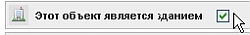
[edit] This place is a building
As Wikimapia is a mapping website, it is important to distinguish different object types on the map. One of the most crucial aspects of a good map is to differentiate buildings from non-buildings. If the place you are marking is a building then you should check the building check box in the edit window. The effect of a ticked box is to cause the place to display in dark grey on the Wikimapia map. Removing the tick causes the place to display in light grey. So, it is crucial this feature is used correctly to render the proper shade. For these purposes a "building" is a contiguous built structural feature, which is typically seen as having both walls and a roof. It does not include any surrounding grounds and features, such as e.g. gardens, car parking and footpath access etc. If you want to include such features in your polygon do not tick the building box.
This field has a default that depends on the category chosen but take care as the default may be wrong. Obviously, for place tags, which are not buildings (e.g. parks, lakes, public squares etc.) ensure that the building check box is not checked, otherwise the entire polygon will be incorrectly rendered as a building and will conceal actual place tag buildings inside it in the 'Map view'. For a suggestion of how best to make use of this feature see Hint and tip number 2 below.
[edit] Фотографии
Фотографии — неотъемлемая часть описания географического местоположения, и это проявляется на таких сайтах Flickr и Panoramio и приложений, таких как Google Earth и Picasa. Wikimapia позволяет вам наслаждаться фотографиями мест, позволяя добавить их к их соответствующим объектам.
Чтобы добавить фотографию, нажмите кнопку «Меню» > «Загрузить / удалить фотографии» в карточке объекта. Вы можете загрузить изображение со своего компьютера или загрузить фотографию из Интернета. Пожалуйста, обратите внимание, что фотографии должны быть связаны с объектом и вы не можете добавить материал защищенный авторским правом.
Чтобы добавить фотографию к линейному объекту, надо открыть окно места, у которого есть желаемая улица как ее адрес, и щелкните им. Нажмите «Меню» > «Загрузить / удалить фотографии» в карточке объекта и продолжите добавлять изображение как описано выше.
Основная статья: Фотографии
[edit] Фотографии со знаком авторского права / водяными знаками
Если у вас есть разрешение на использование фотографии или его лицензия разрешает вам использовать его в Wikimapia, вы должны придерживаться его условий распространения. Если вы можете продемонстрировать авторство, вы можете сделать это, написав необходимые данные в комментарии рассматриваемой фотографии. Эта процедура особенно необходима для фотографий, имеющих знак авторского права, водяные знаки. Вы можете также загрузить свои фотографии имеющие или не имеющие подобные знаки.
Конечно, вы должны помнить, что загружая фотографии, вы соглашаетесь с требованиями Terms of Reference.
[edit] Comments
The Comments section, which is available in all Wikimapia objects, allows you to make a comment or add an opinion about the tagged object. This is the only place where you can state an opinion which does not belong to the placetag's article because it is outside the scope of Wikimapia's Neutral Point of View policy. Keep in mind that unwelcome, offensive, meaningless comments, and senseless (without practical advantage) a question-reply chat (chain comments) between the users as well as comments unrelated to the tagged object are not permissible.
To add a comment, enter your text in the comment text box at the bottom of a placetag's window and click 'Send'. Unregistered users will be prompted to add a comment author's name in the 'Your name' text box.
[edit] Parent & Nested Places
Parent & nested places are special place tags that are linked to each other. Parent tags contain nested tags nested within them. This form of tagging is suitable for marking places that are located inside larger places, but the parent tag must be a building to make use of this function.
.jpg)
There are two methods to link nested place tags to parent place tags. There is the embedding method and there is the binding method.
The embedding method is suited to marking places that do not require polygons. This is ideal for places whose delimitation is difficult or impossible to determine within the boundary of the parent tag due to severe overlapping etc. This is also applicable to vertically constructed or multilevel buildings, such as high-rise residential apartments or office buildings.
The binding method is perfect for adding nested places whose boundaries can be defined within the parent tag. This is fitting for tenant-type places that exist in one building under the same roof (eg. shopping malls, retail parks etc.) or for existing tags that were marked before the parent building. In either case, the emphasis of this method is the inclusion of existing tags to be marked congruously on a singular level, floor or storey, within the boundary of the parent tag.
How to create and link an embedded nested place
- Ensure the parent building checkbox has been ticked.
- Select
 located in the window. A new window will open ready for entering embedded nested place details. Once completed, click "Save". It's as simple as that!
How to bind existing nested place
1. Ensure the building checkbox has been ticked in the parent and nested places. ![]() 2. Make sure the polygon of the parent tag encompasses the polygon of the nested place i.e. the boundary of the nested place must not breach or be larger than the parent tag's boundary.
3. Select
2. Make sure the polygon of the parent tag encompasses the polygon of the nested place i.e. the boundary of the nested place must not breach or be larger than the parent tag's boundary.
3. Select ![]() located in the window.
located in the window.
4. Select located at the top of the window.
.jpg)
5. Choose the desired nested place from the dropdown list and then click on the "Bind" button.
.jpg)
You will have successfully linked a nested place to its parent tag, using either of the methods explained above.
When a parent tag is open, you will then be able to view all nested places listed under "In this building".jpg)
Clicking on a nested place will open its window. The layout of the nested place is identical to that of a regular tag except for the header ![]() Clicking on the parent tag's blue label will navigate back to the parent tag's window.
Clicking on the parent tag's blue label will navigate back to the parent tag's window.
The benefit of the binding method is that nested places can be easily unlinked from parent tag to become separate tags.
How to unbind a nested place
To disconnect a nested place from its parent, simply select ![]() from the nested place's menu.
from the nested place's menu.
This only works for nested places nested within parent tags using the binding method, it does not work for embedded nested places because they only exist within parent tags. The removal of a embedded nested place from its parent can only be done by deletion.