Fàrsala
Greece /
Larisa /
Farsala /
World
/ Greece
/ Larisa
/ Farsala
, 1 km from center (Φάρσαλα)
World / Greece / Thessalia
town, archaeological site, municipality
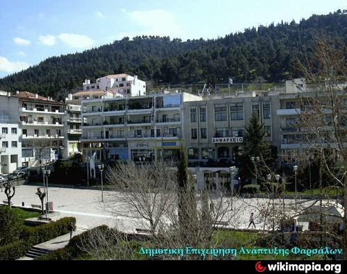
Seat of the Municipality of Fàrsala
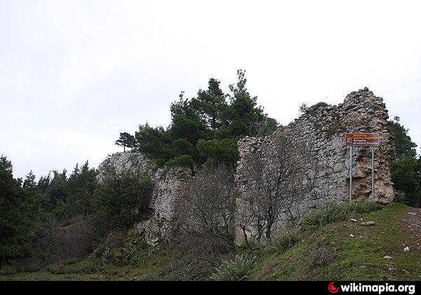
The Homeric Phthia of the Mycenaean period, capital of the Kingdom of the Myrmidons and of Peleus, father of Achilles, has sometimes been identified with the later city of Pharsalos (Greek: Φάρσαλος), now Farsala. A Cyclopean Wall which protected a city still exists today near modern Farsala, as does a vaulted tomb from that period.
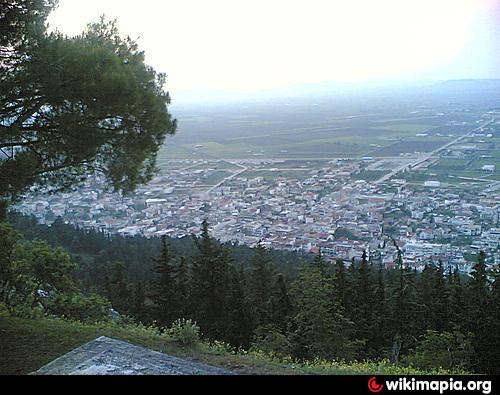
The Pharsalos of the historic era was built over a hillside of the Narthacius mountains at an elevation of some 160 m, where modern Farsala stands. It was one of the main cities in Thessaly and was the capital of the Phthian tetrarch. In the Persian Wars it sided with the Athenians. A distinctive tribe of the city was that of Echecratidon. In the early 4th century BC, the city was a part of the Thessalian Commons. Later, it joined the Macedonian Kingdom under Philip II. The area became a theatre of war where the Aetolians and the Thessalians clashed with the Macedonians, especially during the Second and the Third Macedonian Wars. After the defeat of the Macedonian Kingdom, Pharsalos and the whole area became a part of the Roman Republic.
The whole area suffered great destruction during the Roman Civil War. The Battle of Pharsalus, where Julius Caesar defeated Pompey and changed the course of the Roman Republic forever, took place in 48 BC in the fields of the Pharsalian Plain.
The Battle of Farsala by Georgios Roilos (1867–1928).
The geographer Strabo speaks of two towns, Old Pharsalos, Παλαιοφάρσαλος (Palaeopharsalos) and Pharsalos, existing in historical times. His statement (9.5.6) that the Thetideion, the temple to Thetis south of Skotoussa, was “near both the Pharsaloi, the Old and the New”, seems to imply that Palaeopharsalos was not itself close by Pharsalos. Although the battle of 48 BC is called after Pharsalos, four ancient writers - the author of the Bellum Alexandrinum (48.1), Frontinus (Strategemata 2.3.22), Eutropius (20), and Orosius (6.15.27)- place it specifically at Palaeopharsalos. In 198 B.C. Philip V had sacked Palaeopharsalos (Livy 32.13.9). If that town had been close to Pharsalos he would have sacked both, and Livy would have written “Pharsalus” instead of “Palaeopharsalus”. The British scholar F. L. Lucas demonstrated (Annual of the British School at Athens, No. XXIV, 1919–21) that the battle of 48 BC must have been fought north of the Enipeus, near modern-day Krini. It has been suggested[2] that Krini was built on the site of Palaeopharsalos, where the old road south from Larissa emerged from the hills on to the Pharsalian Plain.
The Homeric Phthia of the Mycenaean period, capital of the Kingdom of the Myrmidons and of Peleus, father of Achilles, has sometimes been identified with the later city of Pharsalos (Greek: Φάρσαλος), now Farsala. A Cyclopean Wall which protected a city still exists today near modern Farsala, as does a vaulted tomb from that period.
The Pharsalos of the historic era was built over a hillside of the Narthacius mountains at an elevation of some 160 m, where modern Farsala stands. It was one of the main cities in Thessaly and was the capital of the Phthian tetrarch. In the Persian Wars it sided with the Athenians. A distinctive tribe of the city was that of Echecratidon. In the early 4th century BC, the city was a part of the Thessalian Commons. Later, it joined the Macedonian Kingdom under Philip II. The area became a theatre of war where the Aetolians and the Thessalians clashed with the Macedonians, especially during the Second and the Third Macedonian Wars. After the defeat of the Macedonian Kingdom, Pharsalos and the whole area became a part of the Roman Republic.
The whole area suffered great destruction during the Roman Civil War. The Battle of Pharsalus, where Julius Caesar defeated Pompey and changed the course of the Roman Republic forever, took place in 48 BC in the fields of the Pharsalian Plain.
The Battle of Farsala by Georgios Roilos (1867–1928).
The geographer Strabo speaks of two towns, Old Pharsalos, Παλαιοφάρσαλος (Palaeopharsalos) and Pharsalos, existing in historical times. His statement (9.5.6) that the Thetideion, the temple to Thetis south of Skotoussa, was “near both the Pharsaloi, the Old and the New”, seems to imply that Palaeopharsalos was not itself close by Pharsalos. Although the battle of 48 BC is called after Pharsalos, four ancient writers - the author of the Bellum Alexandrinum (48.1), Frontinus (Strategemata 2.3.22), Eutropius (20), and Orosius (6.15.27)- place it specifically at Palaeopharsalos. In 198 B.C. Philip V had sacked Palaeopharsalos (Livy 32.13.9). If that town had been close to Pharsalos he would have sacked both, and Livy would have written “Pharsalus” instead of “Palaeopharsalus”. The British scholar F. L. Lucas demonstrated (Annual of the British School at Athens, No. XXIV, 1919–21) that the battle of 48 BC must have been fought north of the Enipeus, near modern-day Krini. It has been suggested[2] that Krini was built on the site of Palaeopharsalos, where the old road south from Larissa emerged from the hills on to the Pharsalian Plain.
Wikipedia article: http://en.wikipedia.org/wiki/Farsala
Nearby cities:
Coordinates: 39°17'48"N 22°22'54"E
- Nafpaktos 111 km
- Kuçovë 272 km
- Lecce 382 km
- Copertino 388 km
- Brindisi 411 km
- Crotone 457 km
- Cariati (Kariati) 470 km
- Massafra 474 km
- Marina di Ginosa 489 km
- Gioia del Colle 496 km
- Fàrsala Ancient Field 0.5 km
- Fàrsala Forest 0.8 km
- Farsala Moto Cross Field 1.4 km
- Prehistoric Acropolis of Phàrsalus 2.5 km
- Military Field 4.6 km
- Polydamada Solar Field 6 km
- Mountain Kassidiaris 6.9 km
- Battle of Pharsalus 9 km
- Peripheral unit of Larissa 41 km
- Peripheral unit of Phthiotis 50 km