the Jungle (Los Angeles, California)
USA /
California /
Marina del Rey /
Los Angeles, California
World
/ USA
/ California
/ Marina del Rey
World / United States / California
neighborhood
Add category
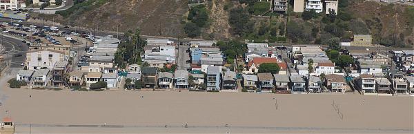
This area of low rent, high density apartment blocks was known in the 1950s and 1960s to students at Loyola University and Westchester High School as the Jungle.
Even then the origin of that appellation was obscure.
Some students said that it was in reference to the beatniks who were living in this area circa 1958-1963, when it was the southernmost end of a bohemian region known as Venice West. (Venice West was where Orson Welles filmed "Touch of Evil," so you can see how rundown the neighborhood was in those days, when there were still old oil wells everywhere.) Certainly the concentration of these small units in a compact area was more suitable for a bachelor pad than a place to raise a family.
Wikipedia article: http://en.wikipedia.org/wiki/Playa_del_Rey
Nearby cities:
Coordinates: 33°57'22"N 118°26'57"W
- Playa del Rey 2.2 km
- Venice 6.8 km
- Westwood 14 km
- Wilmington 22 km
- Shadow Hills 35 km
- Tujunga 40 km
- Mission Oaks 61 km
- Northeast Bakersfield 173 km
- Derby Acres, California 181 km
- West Visalia 280 km
- Playa del Rey 1.5 km
- The Marina 1.8 km
- Ballona Wetlands 1.9 km
- Dockweiler State Beach 2 km
- Marina del Rey, California 2.1 km
- Venice 3.6 km
- Los Angeles International Airport (LAX/KLAX) 4 km
- Del Rey 4.4 km
- Westchester 4.7 km
- South Bay 14 km