Lower Spokane Falls (Spokane, Washington)
USA /
Washington /
Spokane /
Spokane, Washington
World
/ USA
/ Washington
/ Spokane
World / United States / Washington
water, waterfall, hydroelectric power station/plant
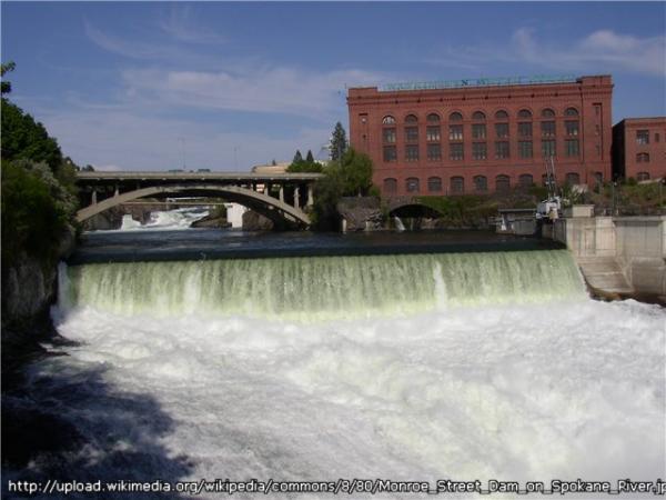

Spokane Falls is one of the largest waterfalls by volume in Washington State. Unfortunately, shortly after the falls were discovered, and the city of Spokane founded, the falls were harnessed for hydropower and irrigation, thus detracting from the natural beauty.
www.world-waterfalls.com/waterfall.php?num=164
The hydroelectric development is called Monroe Street and is operated by Avista Utilities. Power has been produced here since 1890, and a new underground powerhouse with a 14.8 megawatt capacity was built in 1992.
www.avistautilities.com/resources/relicensing/spokane/p...
Wikipedia article: http://en.wikipedia.org/wiki/Spokane_Falls
Nearby cities:
Coordinates: 47°39'41"N 117°25'32"W
- Kootenay Canal hydroelectric generating station 201 km
- Fitzsimmons Creek Hydro Project 487 km
- Culliton Creek Hydro Project 488 km
- Verdi Hydroelectric Project 934 km
- Garrison Dam 1199 km
- Oahe Dam 1358 km
- Volcano Creek Hydro Powerplant 1394 km
- Wuskwatim Generating Station 1568 km
- Lake W. R. Holway 2228 km
- Taum Sauk Hydroelectric Power Station 2436 km
- West Central 1.5 km
- Emerson / Garfield 1.9 km
- Manito 3 km
- North Hill 4.4 km
- Northwest Spokane 5.9 km
- Balboa 7.5 km
- Five Mile 8.1 km
- Five Mile Prairie 8.8 km
- Riverside State Park 11 km
- North Indian Trail 11 km