Archaeological site of the Harbour quarter – agora
Greece /
Dodekanisos /
Kos /
World
/ Greece
/ Dodekanisos
/ Kos
, 0 km from center (Κως)
World / Turkey / Mugla
ancient, archaeological site, interesting place

Human habitation on the site of the present town of Kos is attested from the end of the Early Bronze Age (2300-2000 BC). In the Minoan and Mycenaean periods (2nd millennium BC) the settlement developed into an important centre. This shrunk during the Geometric period (10th-8th c. BC) but flourished again in Archaic and Classical times (7th-5th c. BC). The most important event in its history is the synoecism of 366/5 BC, when the earlier communities on the island united to found the new city at the northeast tip of Kos. The basic structures of this city were preserved unchanged into Early Christian times (6th c. AD). During the Middle Ages the city of Kos was confined within the bounds of the walled burg of the Knights of St John, subsequently known as the Chora neighbourhood.
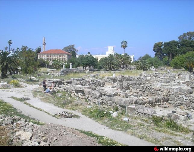
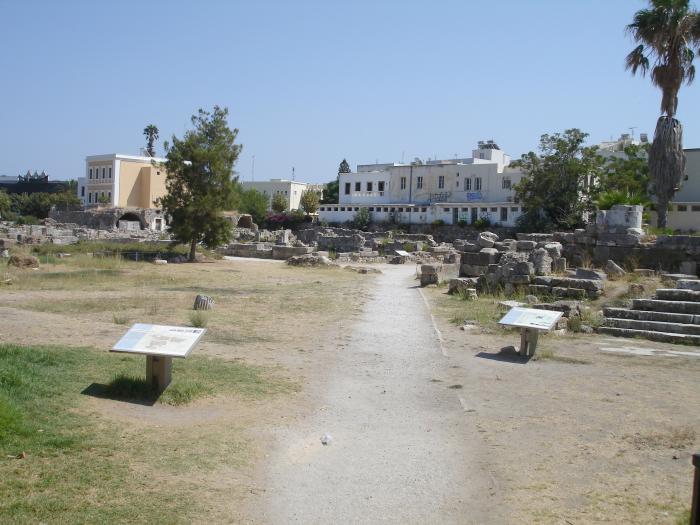
On 23 April 1933 Kos was hit by a catastrophic earthquake of 6.6 on the Richter scale, which razed the town to the ground. The neighbourhood that suffered the worst damage was Chora. On this site, currently known as the Harbour quarter – agora, 30,000 sq. m. in area, the Italian Archaeological Service carried out extensive excavations between 1934 and 1942, bringing to light a large part of the ancient city, mainly from the Hellenistic period and Late Antiquity.
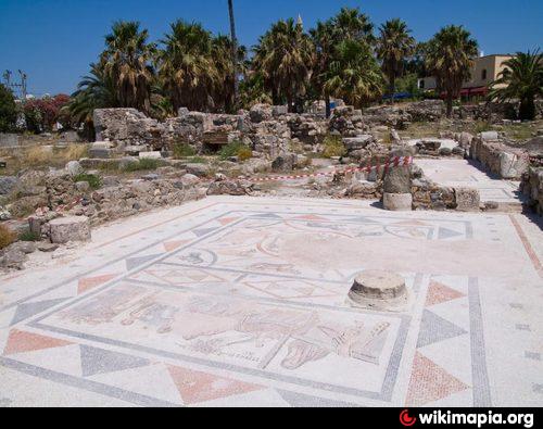
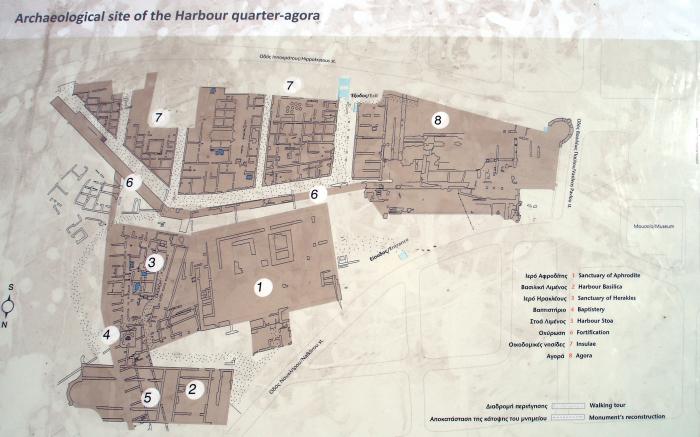
The Harbour quarter was uncovered, which included sanctuaries and public buildings – the double sanctuary of Aphrodite, the sanctuary of Herakles, a sanctuary of an unknown deity, the Harbour stoa, the basilica, the baptistery – as well as a large part of the urban tissue of the city and part of the wall with the fortified towers.
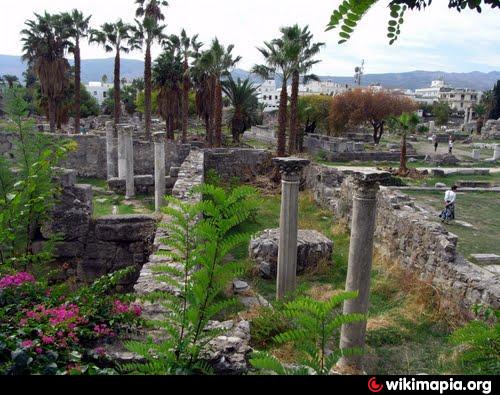
The agora of Kos, one of the largest in the ancient world, was about 350 m. long and lay at the heart of the city. It occupied 16 building insulae of the urban grid, which was laid out according to the Hippodamian system. The agora comprised a central court surrounded by stoas and shops. The monumental complex began in the harbour area, abutting the fortification wall, and ended at the'main thoroughfare, approx. 33 m. wide. it was bounded also to east and west by two streets, the east of which (width 8.80 m.) was one of the most important axes of the city. The agora was built upon a manmade embankment, which bridged the difference in height between the harbour area and the southern quarters of the city.
The north sector, which was excavated and partially restored by the Italian Archaeological Service, was mainly commercial in character, due to its proximity to the port. Its existence on this site is confirmed by the toponyms of monuments located in the area: porta tou Forou (= Forum gate) and ekklesia tis Panagias tou Forou (= church of the Virgin of the Forum). The south sector was excavated by the Greek Archaeological Service.
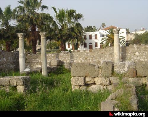
Construction of the agora began in the late 4th-eariy 3rd century BC. A Doric stoa enclosed its square. Shops developed on the east side and, in small number, on the south. Between the agora and the fortification wall run a narrow passage and a stairway leading to the walkway of the enceinte. The south sector of the agora, which was a short distance from the acropolis and its environs, widened westwards so that buildings associated with administration and cult could be erected.
In the second century BC, in the framework of the general programme for public buildings in the city, the agora was reconstructed almost in toto and acquired a monumental aspect, heightened by the use in the colonnades of white Koan marble from the quarries on Mount Dikaios. At this time, north-east from the so-called altar of Dionysos the temple of the Attalids was founded.
The earthquake of AD 142 caused extensive damage to the agora. Large-scale repairs followed, in the course of which a monumental propylon was added to the north side, and a broad staircase leading from the harbour area into the agora, thus changing its use from commercial to civic, dedicated to imperial cult.
The agora was destroyed in the earthquake of AD 469 or 554.
On 23 April 1933 Kos was hit by a catastrophic earthquake of 6.6 on the Richter scale, which razed the town to the ground. The neighbourhood that suffered the worst damage was Chora. On this site, currently known as the Harbour quarter – agora, 30,000 sq. m. in area, the Italian Archaeological Service carried out extensive excavations between 1934 and 1942, bringing to light a large part of the ancient city, mainly from the Hellenistic period and Late Antiquity.
The Harbour quarter was uncovered, which included sanctuaries and public buildings – the double sanctuary of Aphrodite, the sanctuary of Herakles, a sanctuary of an unknown deity, the Harbour stoa, the basilica, the baptistery – as well as a large part of the urban tissue of the city and part of the wall with the fortified towers.
The agora of Kos, one of the largest in the ancient world, was about 350 m. long and lay at the heart of the city. It occupied 16 building insulae of the urban grid, which was laid out according to the Hippodamian system. The agora comprised a central court surrounded by stoas and shops. The monumental complex began in the harbour area, abutting the fortification wall, and ended at the'main thoroughfare, approx. 33 m. wide. it was bounded also to east and west by two streets, the east of which (width 8.80 m.) was one of the most important axes of the city. The agora was built upon a manmade embankment, which bridged the difference in height between the harbour area and the southern quarters of the city.
The north sector, which was excavated and partially restored by the Italian Archaeological Service, was mainly commercial in character, due to its proximity to the port. Its existence on this site is confirmed by the toponyms of monuments located in the area: porta tou Forou (= Forum gate) and ekklesia tis Panagias tou Forou (= church of the Virgin of the Forum). The south sector was excavated by the Greek Archaeological Service.
Construction of the agora began in the late 4th-eariy 3rd century BC. A Doric stoa enclosed its square. Shops developed on the east side and, in small number, on the south. Between the agora and the fortification wall run a narrow passage and a stairway leading to the walkway of the enceinte. The south sector of the agora, which was a short distance from the acropolis and its environs, widened westwards so that buildings associated with administration and cult could be erected.
In the second century BC, in the framework of the general programme for public buildings in the city, the agora was reconstructed almost in toto and acquired a monumental aspect, heightened by the use in the colonnades of white Koan marble from the quarries on Mount Dikaios. At this time, north-east from the so-called altar of Dionysos the temple of the Attalids was founded.
The earthquake of AD 142 caused extensive damage to the agora. Large-scale repairs followed, in the course of which a monumental propylon was added to the north side, and a broad staircase leading from the harbour area into the agora, thus changing its use from commercial to civic, dedicated to imperial cult.
The agora was destroyed in the earthquake of AD 469 or 554.
Nearby cities:
Coordinates: 36°53'37"N 27°17'26"E
- Kildara (Carian) 19 km
- Bargilia 41 km
- Bybassos (Carian) 47 km
- Nimos 54 km
- Miletus 72 km
- Lake Bafa 74 km
- Magnesia Meandrum 109 km
- Ancient Ephesus 117 km
- Lebedos (Ionian) 136 km
- Sardis 190 km
- Harbour 0.3 km
- Atlantis Hotel 2.3 km
- Cape Skandari 2.4 km
- Kipriotis Kos Complex ***** 3.7 km
- Kipriotis Panorama Aqualand **** 3.8 km
- Kipriotis Village Resort 4* 4 km
- Cape Psalidi Protected Area 4.5 km
- Kos 18 km
- Gulf of Gökova 48 km
- Muğla Province 107 km