NSGA Homestead AN/FRD-10 Array, Site Alpha
| military, antenna, abandoned / shut down
USA /
Florida /
Homestead /
World
/ USA
/ Florida
/ Homestead
World / United States / Florida
military, antenna, abandoned / shut down
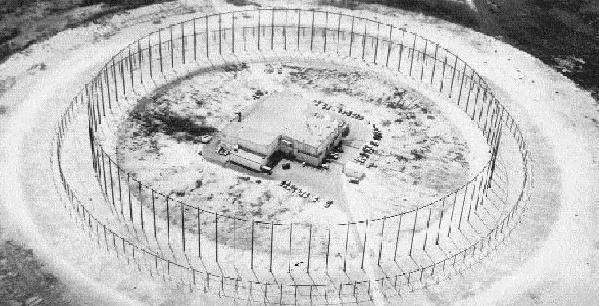
This former Naval Security Group HF/DF station was used to intercept and locate voice and message traffic transmitted on short-wave channels. The station closed in 1993 due to hurricane damage.
There were sixteen AN/FRD-10 high-frequency direction-finding arrays built by the United States and Canada during the 1960s and 1970s. These sixteen stations, along with a number of Pusher HF/DF arrays, comprised the US Naval Security Group's BULLSEYE HFDF net. Pushers was simply the name given to simpler CDAAs.
The arrays operated in the range of 2 to 32 MHz. Their function was to detect, monitor, and plot the location of Soviet submarines and other radio emitters in the Atlantic and Pacific oceans. The largest array was some 260 m in diameter, 36 m high, and sat on a ground plane of 390 m diameter, with a two storey building at its centre, housing the main equipment and operators.
A heliport was once located here:
www.topozone.com/map.asp?lat=25.37254&lon=-80.42342&dat...
www.fas.org/irp/program/collect/classic_bullseye.htm
www.navycthistory.com/homestead_intro.html
luxexumbra.blogspot.com/2005/06/frd-10-endangered-speci...
Wikipedia article: http://en.wikipedia.org/wiki/Wullenweber
Nearby cities:
Coordinates: 25°22'21"N 80°25'24"W
- L-Carrier Cables 5.6 km
- USCG Communication Station, Miami, Site Bravo 8.4 km
- Weapons Storage Area (WSA) 13 km
- Homestead Air Reserve Base 15 km
- Cold War Misslie Site (I-HAWK) 23 km
- US Coast Guard Housing Area 28 km
- Site of Richmond Naval Air Station 28 km
- US Coast Guard Air Station Miami 62 km
- Cudjoe Key Tethered Aerostat Radar Site 133 km
- Former location of Fort Denaud 187 km
- Turkey Point Cooling Canals 7.9 km
- Navy Wells Pineland Preserve 11 km
- Homestead Air Reserve Base 13 km
- Waterstone 13 km
- Leisure City, Florida 14 km
- Redland 19 km
- Biscayne National Park 19 km
- Miami-Dade County, Florida 22 km
- Biscayne Bay 22 km
- Everglades National Park 53 km
Comments