Enrile
Philippines /
Cagayan Valley /
Enrile /
World
/ Philippines
/ Cagayan Valley
/ Enrile
World / Philippines / Cagayan / Enrile
town, municipality, third-level administrative division
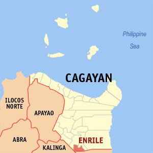
Municipality of Enrile, Province of Cagayan
ZIP Code: 3501
Enrile is a landlocked municipality in the province of Cagayan in the Philippines. As of the 2010 census, it had a population of 32,553 people.
Enrile is politically subdivided into 22 barangays:
-Alibago
-Barangay I (Villa Maria)
-Barangay II (Poblacion)
-Barangay III (San Roque)
-Barangay III-A
-Barangay IV (Poblacion)
-Batu
-Divisoria
-Inga
-Lanna
-Lemu Norte
-Liwan Norte
-Lemu Sur
-Liwan Sur
-Maddarulug Norte
-Maddarulug Sur
-Magalalag East
-Magalalag West (San Nicolas)
-Maracuru
-Roma Norte
-Roma Sur
-San Antonio
Wikipedia article: http://en.wikipedia.org/wiki/Enrile,_Cagayan
Nearby cities:
Coordinates: 17°33'59"N 121°42'8"E
- Peñablanca 29 km
- San Mariano 63 km
- Conner 77 km
- Lal-lo 77 km
- Echague 90 km
- Dinapigue 91 km
- Kabugao 110 km
- Tineg 115 km
- Calanasan 136 km
- Nueva Era 144 km
- Enrile Town Proper 1.1 km
- Sinupac Hills 3.2 km
- Rio Del Grande Subdivision 4.2 km
- Perpetual Village Phase III 5.1 km
- Centro 4 6.1 km
- Saint Paul University Philippines 6.1 km
- Centro 12 6.8 km
- SM City Tuguegarao 7.1 km
- San Jose Village 7.4 km
- Sanctuary of Peace (Tuguegarao Memorial Park) 7.7 km
Comments