Yaylata National Archaeological Reserve
Bulgaria /
Dobric /
Sabla /
World
/ Bulgaria
/ Dobric
/ Sabla
, 11 km from center (Шабла)
World / Bulgaria / Dobrich
interesting place, Natura 2000, animal sanctuary


"Yaylata" is a national archaeological reserve on 1989.
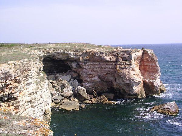
It is a seaside ledge, separated from the Dobrudzhansko Plateau by 50-60-metre cliff massifs.
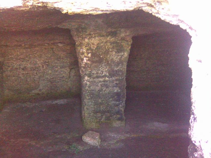
Numerous monuments can be found in the area of the reserve. They date back from different ages. 101 caves have been documented - single ones or in groups. They had been used as homes for thousands of years, some of them used to be tombs or churches. Some of the excavated tools date back to the 5th century BC.
There are three necropolis scooped in the cliff massif. They constitute two-chamber family tombs that have an antechamber and a grave chamber, dating back to 3-5 century. Necropolis 1 has the greatest number of tombs that have been discovered. It had emerged around a sanctuary engraved into the cliff, turned towards the rising sun.
Yayla (in Turkish: yayla, yaylà - plateau, high pasture) is a national archaeological reserve in Dobrich region with Order № 1047 of 22.12.1987, № 2/1988 of the State Gazette.
gowhere.bg/en/places/cultural-heritage/archeological-re...
bulgariatravel.org/kamen-bryag-stone-coast/
www.directbooking.ro/landmark-national-archaeological-r...
audiotravelguide.ro/en/archaeological-reserve-yailata-1...
www.mirela.bg/en/naemi/%D0%A0%D0%B5%D0%B7%D0%B5%D1%80%D...
www.impact-tour.eu/obekti/obekti-v-bulgaria/culturaltou...
bgwalk.com/en/tourist-sites/yajlata
www.bg-guide.org/en/show-places/view/archaeological-res...
routes.e-tours.bg/en/place/prirodno-arkheologicheski-re...
----------
Yaylata and its surroundings have been declared as a protected area by Order № 1047 of 22 December 1987 of the Committee for Environmental Protection at the Council of Ministers, promulgated in issue № 2/1988 of the State Gazette.
Area: 45.3 hectares.
bit.ly/3nmRU4v
www.protectedplanet.net/179245
eunis.eea.europa.eu/sites/179245
www.youtube.com/watch?v=E4JnLXF-cFw
www.youtube.com/watch?v=K6BDSQ034NA
It is a seaside ledge, separated from the Dobrudzhansko Plateau by 50-60-metre cliff massifs.
Numerous monuments can be found in the area of the reserve. They date back from different ages. 101 caves have been documented - single ones or in groups. They had been used as homes for thousands of years, some of them used to be tombs or churches. Some of the excavated tools date back to the 5th century BC.
There are three necropolis scooped in the cliff massif. They constitute two-chamber family tombs that have an antechamber and a grave chamber, dating back to 3-5 century. Necropolis 1 has the greatest number of tombs that have been discovered. It had emerged around a sanctuary engraved into the cliff, turned towards the rising sun.
Yayla (in Turkish: yayla, yaylà - plateau, high pasture) is a national archaeological reserve in Dobrich region with Order № 1047 of 22.12.1987, № 2/1988 of the State Gazette.
gowhere.bg/en/places/cultural-heritage/archeological-re...
bulgariatravel.org/kamen-bryag-stone-coast/
www.directbooking.ro/landmark-national-archaeological-r...
audiotravelguide.ro/en/archaeological-reserve-yailata-1...
www.mirela.bg/en/naemi/%D0%A0%D0%B5%D0%B7%D0%B5%D1%80%D...
www.impact-tour.eu/obekti/obekti-v-bulgaria/culturaltou...
bgwalk.com/en/tourist-sites/yajlata
www.bg-guide.org/en/show-places/view/archaeological-res...
routes.e-tours.bg/en/place/prirodno-arkheologicheski-re...
----------
Yaylata and its surroundings have been declared as a protected area by Order № 1047 of 22 December 1987 of the Committee for Environmental Protection at the Council of Ministers, promulgated in issue № 2/1988 of the State Gazette.
Area: 45.3 hectares.
bit.ly/3nmRU4v
www.protectedplanet.net/179245
eunis.eea.europa.eu/sites/179245
www.youtube.com/watch?v=E4JnLXF-cFw
www.youtube.com/watch?v=K6BDSQ034NA
Wikipedia article: http://en.wikipedia.org/wiki/Yaylata
Nearby cities:
Coordinates: 43°26'2"N 28°32'24"E
- Bolata Canyon 8.7 km
- Cape Kaliakra 9 km
- Neolithic settlement 81 km
- Allah Bair Hill 123 km
- Dolojman Cape & Argamum Fortress 151 km
- Caugagia (Bal-Bair) Hill 151 km
- Ghiunghiurmez Hill 175 km
- Popina Island 175 km
- Izvoarele 179 km
- Caraorman Forest 194 km
- "Yaylata" Protected Site 0.6 km
- "Kompleks Kaliakra" PZ 1.5 km
- Rusalka 2.8 km
- Taukliman (Bird bay)Tauk Bay Estuary 3.8 km
- "Taukliman" Nature Reserve 3.8 km
- Kaliakra PZ 4.3 km
- Saint Nicholas Wind Power Plant 5.7 km
- "Kaliakra" Nature Reserve 7 km
- Kavarna Municipality 14 km
- Dobrich Province 57 km