Cuc Phuong National Park
Vietnam /
Khu Bon Cu /
Bien San /
World
/ Vietnam
/ Khu Bon Cu
/ Bien San
World / Vietnam / Đồng Bằng Sông Hồng / Ninh Bình / Nho Quan
forest, nature conservation park / area, interesting place, national park


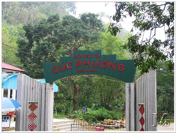


Cuc Phuong National Park (Vietnamese: Vườn quốc gia Cúc Phương) is located in Ninh Binh Province, in Vietnam's Red River Delta. Cuc Phuong was Vietnam's first national park and is the country's largest nature reserve. The park is one of the most important sites for biodiversity in Vietnam.
In 1960 Cuc Phuong was made into a forest reserve and in 1962 Cuc Phuong National Park was consecrated by President Ho Chi Minh. Human habitation in Cuc Phuong dates back long before the park’s creation, 7,000-12,000 years ago. Artifacts from that time have been found in numerous caves within the park, including human graves, stone axes, pointed bone spears, oyster shell knives, and tools for grinding. In 1789 the Quen Voi section of the park was the site of a major battle in the civil war between Nguyen Hue and Thanh Long. More recently, conflicts have emerged between the government and 2,500 Muong ethnic minority tribesmen who live, farm, and hunt in the park. In 1987, 500 Muong were relocated outside of the park because of issues over poaching and land use.
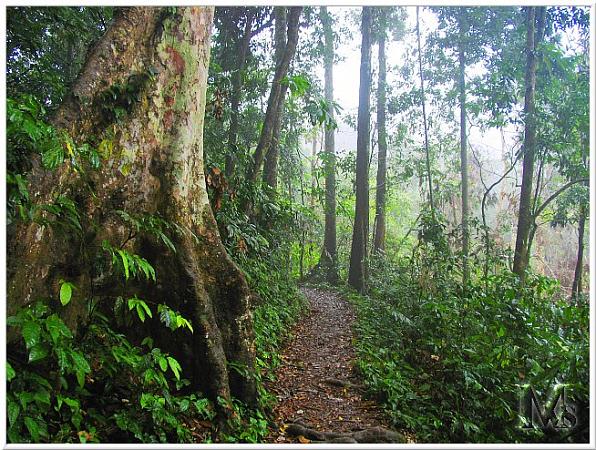
Cuc Phuong is situated in the foothills of the northern Annamite Mountains. The park consists of verdant karst mountains and lush valleys. Elevation varies from 150 meters (500 feet) to 656 m (2,152 feet) at the summit of May Bac Mountain, or Silver Cloud Mountain. The limestone mountains house numerous caves, many of which are accessible for exploration.
The average temperature in Cuc Phuong is 21 Celsius (70 Fahrenheit), with a mean winter temperature of 9C (48F). High temperatures can reach above 30C (85 F) and lows are just above zero (32 F). At the low elevations in the valley the temperature is hot and humid while at higher elevations the temperature drops and frostbite is a threat. On average it rains more than 200 days a year and the average annual rainfall is 2,100mm (7 feet). The dry season is November to February, the driest months being December and January.
To the most beautiful CUC Phuong is the dry season from December to April, when intense rains go through to leave a bright blue sky. Here, visitors are visiting several caves with sexy names such as Dongshan, the D-flat Crescent, Code, ... what makes this place has some caves become tempting tourists by the remains of a prehistoric people who retain it as The ancients, Moong cave (cave of Bitters). Hang The Moong is near streams and rivers, the area has a rich animal and plant diversity, so has been chosen as the stock of long-term residence. CUC Phuong National Park, however the majority of the Ninh Binh province but hang The Moong back in The Saddle, Shicheng district, Thanh Hoa province. Hang long and wide, with 2 interconnecting doors, have quite thick cultural strata, structures are complex, there are interlace succession of the clay cover, the krill and the trail of coal ash. CUC Phuong is the garden of peace of the geometry and the optical code. The Lake contains a small island, on which there is an ancient temple. The lake water is where ...
In 1960 Cuc Phuong was made into a forest reserve and in 1962 Cuc Phuong National Park was consecrated by President Ho Chi Minh. Human habitation in Cuc Phuong dates back long before the park’s creation, 7,000-12,000 years ago. Artifacts from that time have been found in numerous caves within the park, including human graves, stone axes, pointed bone spears, oyster shell knives, and tools for grinding. In 1789 the Quen Voi section of the park was the site of a major battle in the civil war between Nguyen Hue and Thanh Long. More recently, conflicts have emerged between the government and 2,500 Muong ethnic minority tribesmen who live, farm, and hunt in the park. In 1987, 500 Muong were relocated outside of the park because of issues over poaching and land use.
Cuc Phuong is situated in the foothills of the northern Annamite Mountains. The park consists of verdant karst mountains and lush valleys. Elevation varies from 150 meters (500 feet) to 656 m (2,152 feet) at the summit of May Bac Mountain, or Silver Cloud Mountain. The limestone mountains house numerous caves, many of which are accessible for exploration.
The average temperature in Cuc Phuong is 21 Celsius (70 Fahrenheit), with a mean winter temperature of 9C (48F). High temperatures can reach above 30C (85 F) and lows are just above zero (32 F). At the low elevations in the valley the temperature is hot and humid while at higher elevations the temperature drops and frostbite is a threat. On average it rains more than 200 days a year and the average annual rainfall is 2,100mm (7 feet). The dry season is November to February, the driest months being December and January.
To the most beautiful CUC Phuong is the dry season from December to April, when intense rains go through to leave a bright blue sky. Here, visitors are visiting several caves with sexy names such as Dongshan, the D-flat Crescent, Code, ... what makes this place has some caves become tempting tourists by the remains of a prehistoric people who retain it as The ancients, Moong cave (cave of Bitters). Hang The Moong is near streams and rivers, the area has a rich animal and plant diversity, so has been chosen as the stock of long-term residence. CUC Phuong National Park, however the majority of the Ninh Binh province but hang The Moong back in The Saddle, Shicheng district, Thanh Hoa province. Hang long and wide, with 2 interconnecting doors, have quite thick cultural strata, structures are complex, there are interlace succession of the clay cover, the krill and the trail of coal ash. CUC Phuong is the garden of peace of the geometry and the optical code. The Lake contains a small island, on which there is an ancient temple. The lake water is where ...
Wikipedia article: http://en.wikipedia.org/wiki/Cuc_Phuong_National_Park
Nearby cities:
Coordinates: 20°18'30"N 105°37'42"E
- Pu Mat National Park 186 km
- Khao Yai National Park 798 km
- Namdhapha National Park 1254 km
- Royal Manas National Park 1709 km
- Taman Nasional Ulu Masen Aceh 1980 km
- Gunung Leuser National Park [part 2] 2050 km
- Gunung Leuser National Park 2056 km
- "Betung Kerihun" National Park 2203 km
- Bogani Nani Wartabone National Park 2915 km
- Aketajawe-Lolobata National Park 3230 km
- Nho Quan District 7.9 km
- Huyện Thạch Thành (Quê của Phạm Văn Anh) 11 km
- Yen Thuy district 12 km
- Yen Nghiep commune 15 km
- An Nghia commuen 17 km
- Binh Chan commune 19 km
- Binh Hem commune 21 km
- Tan My commune 21 km
- Lac Thuy district 23 km
- Lac Son district 29 km
Comments