South Khorasan Province
Iran /
Khorasan /
Birjand /
World
/ Iran
/ Khorasan
/ Birjand
, 20 km from center (بيرجند)
World / Iran / South Khorasan
province, first-level administrative division, draw only border

South Khorasan (Persian: خراسان جنوبی) is one of the 30 provinces of Iran, located in the eastern part of the country. It is one of the three provinces that were created after the division of Khorasan province in 2004. It borders Razavi Khorasan province in the north, Yazd province in the west, Kerman and Sistan and Baluchistan provinces in the south and Afghanistan in the east. South Khorasan covers an area of 82,864 km² and has a population of 636,420 (2005). It has 7 counties and its center is Birjand; other major cities are Ferdows and Qaen.
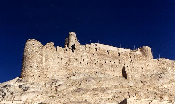
Greater Khorasan has witnessed the rise and fall of many dynasties and governments in its territory throughout history. Ancient geographers of Iran divided Iran (Iran-Shahr) into eight segments, of which the most flourishing and largest was the territory of Greater Khorasan. The famous Parthian Empire was based near Merv in Khorasan for many years. However they did have many fortifications and strongholds in Khorasan, such as the Nehbandan castle in South Khorasan province. During the Sassanid dynasty the province was governed by an Espahbod (Lieutenant General) called "Padgoosban" and four margraves, each commander of one of the four parts of the province. Khorassan was divided into four parts during the Islamic Conquest of Iran and each section was named after the four large cities, such as Neyshabour, Merv, Herat, and Balkh.
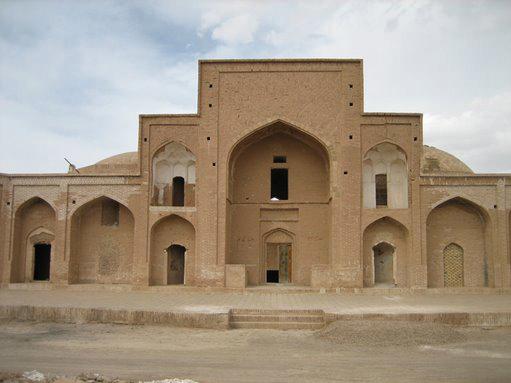
South Khorasan has many historical and natural attractions. Some of these popular attractions are Ferdows Hot Mineral Spring, Ferdows Congregation Mosque or Jame’ mosque of Ferdows, Ferdows Religious School, Nehbandan citadel, Furg citadel, Ferdows Religious School, Kolah Farangi mansion in Birjand, Ghal'eh Paeen-Shahr, Chahr Derakht Mosque, Amir Abad garden, Behgard Garden, Akbariyeh Garden, Chenshat cave, Jame’ mosque of Birjand, Imamzadeh Mosa, Alam palace and Deragon Cave in Sarayan.
Greater Khorasan has witnessed the rise and fall of many dynasties and governments in its territory throughout history. Ancient geographers of Iran divided Iran (Iran-Shahr) into eight segments, of which the most flourishing and largest was the territory of Greater Khorasan. The famous Parthian Empire was based near Merv in Khorasan for many years. However they did have many fortifications and strongholds in Khorasan, such as the Nehbandan castle in South Khorasan province. During the Sassanid dynasty the province was governed by an Espahbod (Lieutenant General) called "Padgoosban" and four margraves, each commander of one of the four parts of the province. Khorassan was divided into four parts during the Islamic Conquest of Iran and each section was named after the four large cities, such as Neyshabour, Merv, Herat, and Balkh.
South Khorasan has many historical and natural attractions. Some of these popular attractions are Ferdows Hot Mineral Spring, Ferdows Congregation Mosque or Jame’ mosque of Ferdows, Ferdows Religious School, Nehbandan citadel, Furg citadel, Ferdows Religious School, Kolah Farangi mansion in Birjand, Ghal'eh Paeen-Shahr, Chahr Derakht Mosque, Amir Abad garden, Behgard Garden, Akbariyeh Garden, Chenshat cave, Jame’ mosque of Birjand, Imamzadeh Mosa, Alam palace and Deragon Cave in Sarayan.
Wikipedia article: http://en.wikipedia.org/wiki/South_Khorasan_Province
Nearby cities:
Coordinates: 32°34'36"N 59°8'7"E
- Balochistan Province 172 km
- Kerman Province 446 km
- Punjab Province 965 km
- Rajasthan 1021 km
- Gujarat 1229 km
- Madhya Pradesh 1587 km
- Uttar Pradesh 1727 km
- Maharashtra 1810 km
- Karnataka 2171 km
- Andhra Pradesh 2290 km
- اصغریه 2.8 km
- روستای پنج تن 4.3 km
- آغل کوه گیوشاد 10 km
- Photos 12 km
- قبرستان 13 km
- کمر قلعه 13 km
- کمر سیاه 13 km
- کمر استینج 13 km
- sade khaki 13 km
- Baghraan Mountains, 2690 m 24 km
Comments