Manzanar National Historic Site
USA /
California /
Lone Pine /
World
/ USA
/ California
/ Lone Pine
World / United States / California
Second World War 1939-1945, military, camp, internment, NRHP - National Register of Historic Places, interesting place, historic landmark


Manzanar War Relocation Center, 1942 to 1945. The yellow outline marks the barbed wire outer perimeter of the Manzanar internment camp.
Manzanar, which means "apple grove" in Spanish, was originally the site of apple orchards and a small community of farmers and ranchers before its more infamous incarnation as a WWII relocation center for Japanese-Americans. The completion of the Los Angeles Aqueduct doomed the small town, as much of the water necessary to irrigate the orchards was piped to L.A. instead. Visitors to the site while the camp was in the planning stages mention withered old apple trees growing among desert weeds.
Established in March, 1942 as the "Owens Valley Reception Center," it was at first run by the U.S. Army's Wartime Civilian Control Administration (WCCA). It later became the first relocation center to be operated by the War Relocation Authority (WRA).
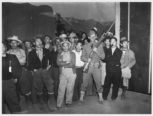
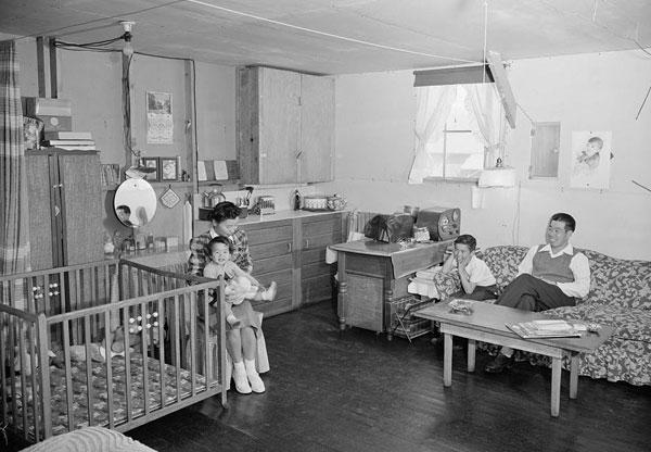
Construction proceeded 10 hours a day 7 days a week; major construction was completed within six weeks. On March 21 1942 the first 82 Japanese Americans made the 220-mile trip by bus from Los Angeles. More volunteers soon followed to help build the relocation center: over the next few days 146 more Japanese Americans arrived in cars and trucks under military escort. Another 500 Japanese Americans, mostly older men, arrived from Los Angeles by train. By mid-April Japanese Americans were arriving every day and by mid-May Manzanar had a population of over 7,000. By September Manzanar's population was just over 10,000. Over 90 percent of the evacuees were from the Los Angeles area.
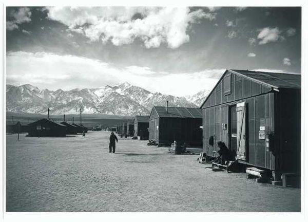
The central developed portion of the relocation center covers an area of approximately 540 acres. Eight watchtowers were completed on the perimeter by August 1942, and a five-strand barbed wire fence around the central area was completed by the end of the year. A military police compound with 13 buildings was located beyond the southeast quarter of the relocation center central area, just south of Bairs Creek.
Partially paved or oiled roads divided the central portion of the relocation center into 67 blocks, including 36 residential blocks, two staff housing blocks, an administrative block, two warehouse blocks, a garage block, and a hospital block. The 24 remaining blocks, located throughout the center, served as firebreaks.
East-west roads were designated by numbers starting with 1st street at the relocation center entrance and proceeding north. The one road south of 1st Street was named Manzanar Street. North-south roads were designated by letters, starting with "A" street on the east and ending with "I" Street on the west. The evacuee residential blocks were designated 1 through 36; none of the other blocks were designated by number.
In late 1971 the Manzanar Committee applied to the California State Department of Parks and Recreation to declare Manzanar as a state historic site, noting that the site "recreates" for many Japanese Americans "that moment in their lives when all the world was enclosed within this one-mile square." In January 1972, the Department of Parks and Recreation designated Manzanar as California Registered Historic Landmark No. 850.
During ceremonies attended by some 1,500 people at the fourth return-to-Manzanar pilgrimage on 14 April 1973, a plaque was placed on the rock sentry house nearest the highway by the State Department of Parks and Recreation in cooperation with the Manzanar Committee and the Japanese American Citizens League. The plaque was installed by Ryozo F. Kado, an 83-year-old Issei who as an evacuee resident at Manzanar had supervised the two rock sentry houses and cemetery monument. For the occasion, Kado reassembled his seven-man evacuee crew.
The Manzanar Committee's fourth pilgrimage and the ceremonies associated with the installation of the plaque were significant in that they "represented the culmination" of more than a year of heated "negotiations with the State Department of Recreation and Parks." The negotiations had involved "torrid controversies over whether such terms as 'concentration camps' and 'racism' ought to be engraved on the plaque which was to make Manzanar a California Historical Landmark." On three occasions, representatives of the Manzanar Committee and the Japanese American Citizens League traveled to Sacramento in an attempt to get their wording accepted by state officials. After the state found other words, such as "hysteria" and "greed," objectionable, the Manzanar Committee enlisted "community support" in "the form of letters and petitions." After a stormy 90-minute confrontation with William Penn Mott, the Director of the state Department of Parks and Recreation who would later become Director of the National Park Service, a compromise was worked out. Under its terms, the state would write the first paragraph on the plaque. The second paragraph, to be written by the Manzanar Committee and the Japanese American Citizens League, declared Manzanar to be the first of 10 such concentration camps confining 10,000 persons bounded within barbed wire and guard towers. The third paragraph incorporated compromise language, allowing the state to include wartime "hysteria" as a contributing element to the government's evacuation program and the Japanese to blame evacuation and relocation on "racism and economic exploitation."
The final wording of the plaque, which would continue to remain the focus of controversy, stated:
"In the early part of World War Two, 110,000 persons of Japanese ancestry were interned in relocation centers by Executive Order No. 9066, issued on February 19, 1942. Manzanar, the first of ten such concentration camps, was bounded by barbed wire and guard towers, confining 10,000 persons, the majority being American citizens. May the injustices and humiliation suffered here as a result of hysteria, racism and economic exploitation never emerge again."
Photos of Manzanar, first week of July, 1942 by Dorothea Lange.
www.manzanarcommittee.org
www.nps.gov/manz/
www.nps.gov/carto/hfc/carto/media/MANZmap1.pdf
Manzanar, which means "apple grove" in Spanish, was originally the site of apple orchards and a small community of farmers and ranchers before its more infamous incarnation as a WWII relocation center for Japanese-Americans. The completion of the Los Angeles Aqueduct doomed the small town, as much of the water necessary to irrigate the orchards was piped to L.A. instead. Visitors to the site while the camp was in the planning stages mention withered old apple trees growing among desert weeds.
Established in March, 1942 as the "Owens Valley Reception Center," it was at first run by the U.S. Army's Wartime Civilian Control Administration (WCCA). It later became the first relocation center to be operated by the War Relocation Authority (WRA).
Construction proceeded 10 hours a day 7 days a week; major construction was completed within six weeks. On March 21 1942 the first 82 Japanese Americans made the 220-mile trip by bus from Los Angeles. More volunteers soon followed to help build the relocation center: over the next few days 146 more Japanese Americans arrived in cars and trucks under military escort. Another 500 Japanese Americans, mostly older men, arrived from Los Angeles by train. By mid-April Japanese Americans were arriving every day and by mid-May Manzanar had a population of over 7,000. By September Manzanar's population was just over 10,000. Over 90 percent of the evacuees were from the Los Angeles area.
The central developed portion of the relocation center covers an area of approximately 540 acres. Eight watchtowers were completed on the perimeter by August 1942, and a five-strand barbed wire fence around the central area was completed by the end of the year. A military police compound with 13 buildings was located beyond the southeast quarter of the relocation center central area, just south of Bairs Creek.
Partially paved or oiled roads divided the central portion of the relocation center into 67 blocks, including 36 residential blocks, two staff housing blocks, an administrative block, two warehouse blocks, a garage block, and a hospital block. The 24 remaining blocks, located throughout the center, served as firebreaks.
East-west roads were designated by numbers starting with 1st street at the relocation center entrance and proceeding north. The one road south of 1st Street was named Manzanar Street. North-south roads were designated by letters, starting with "A" street on the east and ending with "I" Street on the west. The evacuee residential blocks were designated 1 through 36; none of the other blocks were designated by number.
In late 1971 the Manzanar Committee applied to the California State Department of Parks and Recreation to declare Manzanar as a state historic site, noting that the site "recreates" for many Japanese Americans "that moment in their lives when all the world was enclosed within this one-mile square." In January 1972, the Department of Parks and Recreation designated Manzanar as California Registered Historic Landmark No. 850.
During ceremonies attended by some 1,500 people at the fourth return-to-Manzanar pilgrimage on 14 April 1973, a plaque was placed on the rock sentry house nearest the highway by the State Department of Parks and Recreation in cooperation with the Manzanar Committee and the Japanese American Citizens League. The plaque was installed by Ryozo F. Kado, an 83-year-old Issei who as an evacuee resident at Manzanar had supervised the two rock sentry houses and cemetery monument. For the occasion, Kado reassembled his seven-man evacuee crew.
The Manzanar Committee's fourth pilgrimage and the ceremonies associated with the installation of the plaque were significant in that they "represented the culmination" of more than a year of heated "negotiations with the State Department of Recreation and Parks." The negotiations had involved "torrid controversies over whether such terms as 'concentration camps' and 'racism' ought to be engraved on the plaque which was to make Manzanar a California Historical Landmark." On three occasions, representatives of the Manzanar Committee and the Japanese American Citizens League traveled to Sacramento in an attempt to get their wording accepted by state officials. After the state found other words, such as "hysteria" and "greed," objectionable, the Manzanar Committee enlisted "community support" in "the form of letters and petitions." After a stormy 90-minute confrontation with William Penn Mott, the Director of the state Department of Parks and Recreation who would later become Director of the National Park Service, a compromise was worked out. Under its terms, the state would write the first paragraph on the plaque. The second paragraph, to be written by the Manzanar Committee and the Japanese American Citizens League, declared Manzanar to be the first of 10 such concentration camps confining 10,000 persons bounded within barbed wire and guard towers. The third paragraph incorporated compromise language, allowing the state to include wartime "hysteria" as a contributing element to the government's evacuation program and the Japanese to blame evacuation and relocation on "racism and economic exploitation."
The final wording of the plaque, which would continue to remain the focus of controversy, stated:
"In the early part of World War Two, 110,000 persons of Japanese ancestry were interned in relocation centers by Executive Order No. 9066, issued on February 19, 1942. Manzanar, the first of ten such concentration camps, was bounded by barbed wire and guard towers, confining 10,000 persons, the majority being American citizens. May the injustices and humiliation suffered here as a result of hysteria, racism and economic exploitation never emerge again."
Photos of Manzanar, first week of July, 1942 by Dorothea Lange.
www.manzanarcommittee.org
www.nps.gov/manz/
www.nps.gov/carto/hfc/carto/media/MANZmap1.pdf
Wikipedia article: http://en.wikipedia.org/wiki/Manzanar
Nearby cities:
Coordinates: 36°43'38"N 118°9'16"W
- Walerga Collection Center/Camp Kohler (sites) 358 km
- Camp Beale (site) 398 km
- Whiteman Vega 1161 km
- Camp Eagle 1844 km
- Sid Richardson Scout Ranch 1882 km
- Camp Funston 1894 km
- Camp Bullis Military Training Reservation 1972 km
- Camp Meisenbach 2104 km
- Camp Allen Conference & Retreat Center 2175 km
- KIA KIMA Scout Reservation - Chickasaw Council BSA 2367 km
- U.S. National Park Service Grounds 0.4 km
- Independence, California 12 km
- Alabama Hills 13 km
- Alabama Hills 14 km
- Wales Lake 20 km
- Rae Lakes 24 km
- Sequoia National Park 45 km
- Kings Canyon National Park 50 km
- Inyo National Forest 59 km
- Inyo National Forest 83 km
Comments