Prince Edward Viaduct
| bridge, metro station
Canada /
Ontario /
Toronto /
World
/ Canada
/ Ontario
/ Toronto
World / United States / New York
bridge, metro station
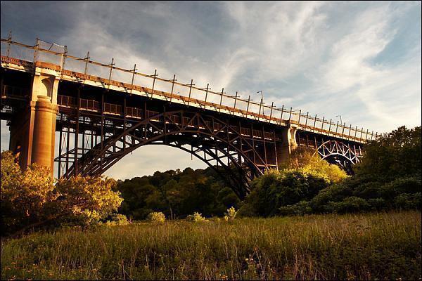
Also known as the Bloor Viaduct. Built 1918 to connect the formerly cottage country east valley with the downtown. A rail deck beneath the bridge allows the city subway system to span the Don Valley. Famous as a major suicide site until the city put up a decorative veil.
Wikipedia article: https://en.wikipedia.org/wiki/Prince_Edward_Viaduct
Nearby cities:
Coordinates: 43°40'30"N 79°21'49"W
- Overpass 3 km
- Skywalk Bridge 3.8 km
- Burnhamthorpe bridge over Credit River 28 km
- Former Church Street Interchange location 31 km
- Former Harwood Avenue Interchange location 34 km
- Whitby, Port Perry, and Lindsay Railway between North Whitby and Myrtle Jct./Crossing 49 km
- Rainbow Bridge (Ontario - New York border crossing) 69 km
- North Grand Island Bridge 73 km
- Wellington & Hwy.6 and 7 75 km
- Glen Morris Bridge 91 km
- Cabbagetown 1.1 km
- Rosedale 1.5 km
- Riverdale 1.5 km
- Regent Park 1.7 km
- South Cabbagetown 1.9 km
- Riverside District 2.1 km
- Corktown 2.2 km
- Leslieville 2.9 km
- Old Toronto 4.5 km
- Lake Ontario 113 km