Kermanshah Province
Iran /
Kermanshah /
Javanrud /
World
/ Iran
/ Kermanshah
/ Javanrud
, 34 km from center (جوانرود)
World / Iran / Kermanshah
province, first-level administrative division, draw only border


Kermanshah Province (Kurdish: Parêzgeha Kirmaşan, Persian: استان کرمانشاه) is one of the 30 provinces of Iran, located in the western part of the country. It borders Iraq and has 14 counties. Kermanshah was formerly known as Bakhtaran, between 1979 and the 1990. It's capital is the city of Kermanshah with a population of 822,921 (2005). Other major cities and towns in Kermanshah Province are, Islamabad-e-gharb, Paveh, Harsin, Kangavar, Sonqor, Javanrood, Salas-e-babajani, Ravansar, Dalahoo, Gilan-Gharb, Sahneh, Qasr-e Shirin and Sarpol-e-Zahab.
Kermanshah is the trade center of rich agricultural region that produces grain, rice, vegetable, fruits, and oilseeds, and there are many industrial centers, oil and sugar refineries, and cement, textile and flour factories, etc.
Kermanshah has a rich paleolithic heritage. Many caves with Paleolithic remains have been surveyed or excavated there. Some of these cave sites are located in Bisotun and north of Kermanshah. The first known physical remains of Neanderthal man in Iran was discovered in Bisotun cave. Do-Ashkaft, Kobeh, Warwasi, and Mar Tarik are some of the Middle Paleolithic sites in the region. Kermanshah also has many Neolithic sites, of which the most famous are Ganj Dareh, Sarab, and Asiab. At Ganj Dareh, the earliest evidence for goat domestication have been documented. The city suffered major damage during the Arab invasions but recovered in the Safavid period to make great progress. Concurrent with the Afghan attack and the fall of Isfahan, Kermanshah was almost completely destroyed by the Ottoman invasion.
Kermanshah Has 3 major Historical attractions dating from Achaemenid to Sassanid period:
1- Bisotun:
Darius the Great's inscription at Bisotun, which dates to 522 BCE, lies some 1300 meters high in the mountains, and counts as one of the most famous sites in Near Eastern archeology. The site is a UNESCO World Heritage Site and has been attracting visitors for centuries. The Bisotun inscription is to Old Persian cuneiform what the Rosetta Stone is to Egyptian hieroglyphs. The trilingual inscription (in Old Persian, Elamite and Akkadian) was crucial in the decipherment of Old Persian script. The relief above the inscription depicts Darius facing nine rebels who objected to his crowning. At the king's feet lies Gaumata. Behistun is also notable for three reliefs at the foot of the hill that date from the Parthian era. Among them is a Hellenistic-era depiction of the divinity Bahram as the Greek hero Hercules, who reclines with a goblet in his hand, a club at his feet and a lion-skin beneath him. Because it lies on the route of an ancient highway, this life-size rock sculpture may reflect Bahram's status as patron divinity of travelers.
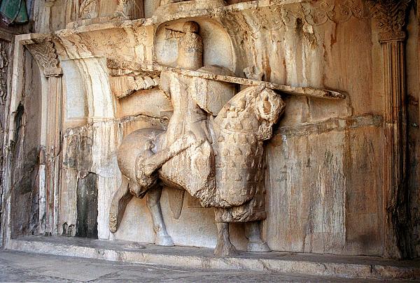
2- Taq-e Bostan:
The rock reliefs at Taq-e Bostan lie four miles north-East of Kermanshah, where a spring gushes from a mountain cliff and empties into a large reflecting pool. One of the more impressive reliefs, inside the largest grotto (ivan), is the oversized depiction of Sassanid king Khosrau II (591-628 CE), who appears mounted on his favorite charger, Shabdiz. Both horse and rider are arrayed in full battle armor. There are two hunting scenes on complementary sides of the ivan, one depicts an imperial boar hunt and the other depicting the king stalking deer. Elephants flush out the boar from a marshy lake for the king who stands poised with bow and arrow in hand while he is serenaded by female musicians following in other boats. These royal hunting scenes are narrative murals in stone are count among the most vivid of all Iranian rock reliefs. The Taq-e Bostan reliefs are not limited to the Sassanid era. An upper relief depicts the 19th century Qajar king Fath-Ali shah holding court.
3- The Kangavar archaeological complex:
Kangavar is the site of the archaeological remains of a vast Hellenic-style edifice on a raised platform. The visible remains at the site date to early Sassanid times, but the platform of the complex may be several centuries older. By the time excavation began in 1968, the complex had been preemptorily associated with a comment by Isidore of Charax who referred to a temple of Anahita at Concobar (the Greek name of Kangavar, which was then in Lower Medea). Despite archaeological findings to the contrary, the association with the divinity of fertility, healing, and wisdom has made the site a popular tourist attraction. The vast edifice was built of enormous blocks of dressed stone with an imposing entrance of opposed staircases that may have been inspired by the Apadana in Persepolis.
Kermanshah is the trade center of rich agricultural region that produces grain, rice, vegetable, fruits, and oilseeds, and there are many industrial centers, oil and sugar refineries, and cement, textile and flour factories, etc.
Kermanshah has a rich paleolithic heritage. Many caves with Paleolithic remains have been surveyed or excavated there. Some of these cave sites are located in Bisotun and north of Kermanshah. The first known physical remains of Neanderthal man in Iran was discovered in Bisotun cave. Do-Ashkaft, Kobeh, Warwasi, and Mar Tarik are some of the Middle Paleolithic sites in the region. Kermanshah also has many Neolithic sites, of which the most famous are Ganj Dareh, Sarab, and Asiab. At Ganj Dareh, the earliest evidence for goat domestication have been documented. The city suffered major damage during the Arab invasions but recovered in the Safavid period to make great progress. Concurrent with the Afghan attack and the fall of Isfahan, Kermanshah was almost completely destroyed by the Ottoman invasion.
Kermanshah Has 3 major Historical attractions dating from Achaemenid to Sassanid period:
1- Bisotun:
Darius the Great's inscription at Bisotun, which dates to 522 BCE, lies some 1300 meters high in the mountains, and counts as one of the most famous sites in Near Eastern archeology. The site is a UNESCO World Heritage Site and has been attracting visitors for centuries. The Bisotun inscription is to Old Persian cuneiform what the Rosetta Stone is to Egyptian hieroglyphs. The trilingual inscription (in Old Persian, Elamite and Akkadian) was crucial in the decipherment of Old Persian script. The relief above the inscription depicts Darius facing nine rebels who objected to his crowning. At the king's feet lies Gaumata. Behistun is also notable for three reliefs at the foot of the hill that date from the Parthian era. Among them is a Hellenistic-era depiction of the divinity Bahram as the Greek hero Hercules, who reclines with a goblet in his hand, a club at his feet and a lion-skin beneath him. Because it lies on the route of an ancient highway, this life-size rock sculpture may reflect Bahram's status as patron divinity of travelers.
2- Taq-e Bostan:
The rock reliefs at Taq-e Bostan lie four miles north-East of Kermanshah, where a spring gushes from a mountain cliff and empties into a large reflecting pool. One of the more impressive reliefs, inside the largest grotto (ivan), is the oversized depiction of Sassanid king Khosrau II (591-628 CE), who appears mounted on his favorite charger, Shabdiz. Both horse and rider are arrayed in full battle armor. There are two hunting scenes on complementary sides of the ivan, one depicts an imperial boar hunt and the other depicting the king stalking deer. Elephants flush out the boar from a marshy lake for the king who stands poised with bow and arrow in hand while he is serenaded by female musicians following in other boats. These royal hunting scenes are narrative murals in stone are count among the most vivid of all Iranian rock reliefs. The Taq-e Bostan reliefs are not limited to the Sassanid era. An upper relief depicts the 19th century Qajar king Fath-Ali shah holding court.
3- The Kangavar archaeological complex:
Kangavar is the site of the archaeological remains of a vast Hellenic-style edifice on a raised platform. The visible remains at the site date to early Sassanid times, but the platform of the complex may be several centuries older. By the time excavation began in 1968, the complex had been preemptorily associated with a comment by Isidore of Charax who referred to a temple of Anahita at Concobar (the Greek name of Kangavar, which was then in Lower Medea). Despite archaeological findings to the contrary, the association with the divinity of fertility, healing, and wisdom has made the site a popular tourist attraction. The vast edifice was built of enormous blocks of dressed stone with an imposing entrance of opposed staircases that may have been inspired by the Apadana in Persepolis.
Wikipedia article: http://en.wikipedia.org/wiki/Kermanshah_Province
Nearby cities:
Coordinates: 34°28'12"N 46°43'46"E
- Kerman Province 766 km
- Balochistan Province 1341 km
- Punjab Province 2079 km
- Rajasthan 2190 km
- Gujarat 2320 km
- Madhya Pradesh 2753 km
- Uttar Pradesh 2885 km
- Maharashtra 2912 km
- Karnataka 3240 km
- Andhra Pradesh 3406 km
- کوزران 12 km
- Tapeh Kheibar 12 km
- tapekal 13 km
- زمین کوچک بل 25 km
- Epicenter of M 4.5 quake 26 km
- Aloct 28 km
Comments