Hiram M. Chittenden (Ballard) Locks, Salmon Fish Ladder, and Botanical Garden (Seattle, Washington)
USA /
Washington /
Seattle /
Seattle, Washington /
Northwest 54th Street, 3015
World
/ USA
/ Washington
/ Seattle
World / United States / Washington
garden, place with historical importance, lock (water navigation), fish ladder

3015 NW 54th Street
Seattle, WA 98107
(206) 783-7059
www.seattle.gov/tour/locks.htm
The facility consists of two locks (one large, one small), a spillway, a fish ladder, a visitors' center, the Carl S. English, Jr., Botanical Gardens, and maintenance buildings.
The locks exist to:
---maintain the water level of Lake Washington and Lake Union at 20.6 feet above Puget Sound's mean low tide
---prevent the mixing of sea water from Puget Sound with the fresh water of the lakes (known as saltwater intrusion), and
---move boats from the water level of the lakes to the water level of Puget Sound, and vice versa.
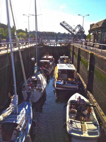
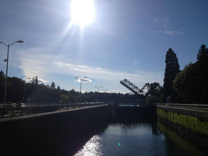
The small lock measures 30 x 150 feet (8.5 x 45.7 meters). During summer, when the lakes receive less inflow, the small lock is used as much as possible to conserve fresh water. The large lock measures 80 x 825 feet (24.4 x 251.5 meters). Having two locks allows one of the locks to be drained for maintenance without blocking all boat traffic (pictures of the drained large lock are located in the Canal lock article).
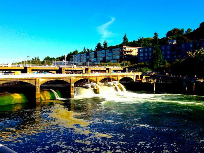
A spillway runs from the large lock to the fish ladder on the opposite side of the Lake Washington Ship Canal. It is 235 feet (71.6 meters) in length and has six gates to assist in controlling the level of the ship canal. The gates measure 12 x 32 feet (3.7 x 9.8 meters).
The grounds also feature a fish ladder for salmon migration, a visitors center, and the Carl S. English, Jr., Botanical Gardens. Also present, but not open to the public, are maintenance facilities.
The facility, operated by the U.S. Army Corps of Engineers, was opened on July 4, 1917, and is named after U.S. Army Major Hiram Martin Chittenden, who was the Seattle District Engineer for the Corps of Engineers from April 1906 to September 1908. The facility was added to the National Register of Historic Places in 1978.
It is a popular place for watching boats move between Lake Washington and Puget Sound. Salmon travel through the fish ladder is prominent in July and early August.
Seattle, WA 98107
(206) 783-7059
www.seattle.gov/tour/locks.htm
The facility consists of two locks (one large, one small), a spillway, a fish ladder, a visitors' center, the Carl S. English, Jr., Botanical Gardens, and maintenance buildings.
The locks exist to:
---maintain the water level of Lake Washington and Lake Union at 20.6 feet above Puget Sound's mean low tide
---prevent the mixing of sea water from Puget Sound with the fresh water of the lakes (known as saltwater intrusion), and
---move boats from the water level of the lakes to the water level of Puget Sound, and vice versa.
The small lock measures 30 x 150 feet (8.5 x 45.7 meters). During summer, when the lakes receive less inflow, the small lock is used as much as possible to conserve fresh water. The large lock measures 80 x 825 feet (24.4 x 251.5 meters). Having two locks allows one of the locks to be drained for maintenance without blocking all boat traffic (pictures of the drained large lock are located in the Canal lock article).
A spillway runs from the large lock to the fish ladder on the opposite side of the Lake Washington Ship Canal. It is 235 feet (71.6 meters) in length and has six gates to assist in controlling the level of the ship canal. The gates measure 12 x 32 feet (3.7 x 9.8 meters).
The grounds also feature a fish ladder for salmon migration, a visitors center, and the Carl S. English, Jr., Botanical Gardens. Also present, but not open to the public, are maintenance facilities.
The facility, operated by the U.S. Army Corps of Engineers, was opened on July 4, 1917, and is named after U.S. Army Major Hiram Martin Chittenden, who was the Seattle District Engineer for the Corps of Engineers from April 1906 to September 1908. The facility was added to the National Register of Historic Places in 1978.
It is a popular place for watching boats move between Lake Washington and Puget Sound. Salmon travel through the fish ladder is prominent in July and early August.
Wikipedia article: http://en.wikipedia.org/wiki/Ballard_Locks
Nearby cities:
Coordinates: 47°39'57"N 122°23'47"W
- Discovery Park 3 km
- West Duwamish Greenbelt 11 km
- Blake Island 16 km
- Banner Forest Heritage Park 23 km
- Pt. Gamble / Pope Forest 27 km
- Dash Point State Park 38 km
- Point Defiance Park 40 km
- Chambers Creek Canyon Park 54 km
- Nisqually National Wildlife Refuge 68 km
- Olympic National Park 148 km
- Kiwanis Memorial Preserve Park 0.5 km
- Ballard 1.2 km
- Parade ground of the former Fort Lawton 1.6 km
- Discovery Park 1.8 km
- Magnolia 1.8 km
- Capture-The-Flag Park 2 km
- Ft. Lawton Riot - The death of Italian POW Guglielmo Olivotto 2 km
- West Point Sewage Treatment Plant 2.4 km
- Magnolia Village, commercial heart of Magnolia 3 km
- Elliott Bay 5.3 km