Alksnynė
Lithuania /
Klaipedos /
Klaipeda /
World
/ Lithuania
/ Klaipedos
/ Klaipeda
World / Lithuania / Klaipedos
hamlet, Cultural heritage of Lithuania
Alksnynė hamlet appeared in 1795. As a forestry it was established in 1898-1907. Before 1945 there lived only a forester with his family. They were doing landscaping and forestry business.
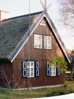
Several families are living in Alksnynė‘s steading. Formerly, a gulf of the Curonian Spit was in this place. While canalizing the watercourse for ships to navigate, this gulf was filled up with the gound excavated. In the end of XIX mentury, while planting the dunes, a dune supervisor‘s farmstead was constructed, which was given the name of Alksnynas. This settlement has Alksnynė‘s control post located, where local toll for entrance of the territory of the National Park of the Curonian Spit is, which is administered by the Municipality of Neringa, is collected. Approximately 500 m from Alksnynė, on the left side of the road, you will see a monument designed for the soldiers of the Red Army, who lost their lives at the end of January, 1945. 3 km from Alksnynė, on the right side of the road, where the forest is somewhat distant from the road, even now you will see the foundations of buildings. In the house that was formerly here, postal road supervisor was living here since the old times. Wooden huts were constructed in this place after Prussian and French War (1870 - 1871); war captives, who were performing the works of planting the dunes‘ sand plains and pre-dunes of this neighborhood, were accommodated here. Later, when the captives were set free, women, who were performing the works of planting the dunes, were accommodated here. Local residents named the valley of the seacoast sand plains by the name of the Valley of Love, and named the dune close to it by the name of the Love Dune.
Several families are living in Alksnynė‘s steading. Formerly, a gulf of the Curonian Spit was in this place. While canalizing the watercourse for ships to navigate, this gulf was filled up with the gound excavated. In the end of XIX mentury, while planting the dunes, a dune supervisor‘s farmstead was constructed, which was given the name of Alksnynas. This settlement has Alksnynė‘s control post located, where local toll for entrance of the territory of the National Park of the Curonian Spit is, which is administered by the Municipality of Neringa, is collected. Approximately 500 m from Alksnynė, on the left side of the road, you will see a monument designed for the soldiers of the Red Army, who lost their lives at the end of January, 1945. 3 km from Alksnynė, on the right side of the road, where the forest is somewhat distant from the road, even now you will see the foundations of buildings. In the house that was formerly here, postal road supervisor was living here since the old times. Wooden huts were constructed in this place after Prussian and French War (1870 - 1871); war captives, who were performing the works of planting the dunes‘ sand plains and pre-dunes of this neighborhood, were accommodated here. Later, when the captives were set free, women, who were performing the works of planting the dunes, were accommodated here. Local residents named the valley of the seacoast sand plains by the name of the Valley of Love, and named the dune close to it by the name of the Love Dune.
Nearby cities:
Coordinates: 55°37'55"N 21°7'52"E
- Yeniseevo (former German village Willkau) 111 km
- Oktjabr'skoe 138 km
- Młyniec 157 km
- Kaczory 161 km
- Jurkiszki 167 km
- Juodkrantė elderate 8.9 km
- Priekulė eldership 14 km
- Curonian Spit National Park (Lithuania) 16 km
- Outer roadstead of Klaipėda sea port 16 km
- Neringa 18 km
- Curonian Lagoon maritime plain 18 km
- Klaipėda district municipality 22 km
- Northwest Samogitian moraine plain 37 km
- Curonian Spit 38 km
- Curonian Lagoon 41 km