Fort Pownall
USA /
Maine /
Stockton Springs /
World
/ USA
/ Maine
/ Stockton Springs
World / United States / Maine
place with historical importance, fortification, interesting place
In 1759, Massachusetts Governor Thomas Pownall sought to plug the mouths of Maine's key rivers so as to keep the French and Indians well inland. In January 1758, he wrote to William Pitt, Prime Minister of England about the advantages of this site, then called Wasaumkeag Point.
"A Fort at Penobscot River would be of utmost importance... It would take possession of the very fine Country... It would effectively drive off the Remains of the Noridgwoak and Penobscot Indians as it would break up their Hunting and Fishing. It would take possession of the finest Bay in North America for large shipping just at the mouth of the Bay of Fundy and would be advancing the Frontiers of his Majesty's Dominions."
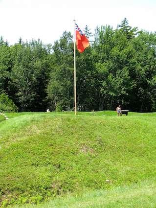
The following year, Pownall led a group of 400 men who established and built a fort here, naming it after the governor. While the fort never fired a shot in anger, its protective presence encouraged Anglo-American settlement in the Penobscot region.
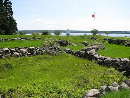
In 1775, British forces seized the fort's cannons and powder. Later, a regiment of Continentals burned the blockhouse and filled in much of the ditch system to prevent the British from occupying the fort.
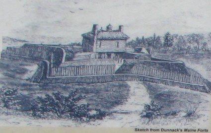
The only record of the fort's style and construction is a plan drawn by an unknown artist (rendered above) that includes such detail that it was likely drawn by someone who had knowledge of the fort.
Revolutionary War veteran Joesph P. Martin never saw the fort, but in 1828 he recorded a description apparently passed on to him by someone who had been there.
It was a regular fortification, four square flankers, with a block house in the centre. It was surrounded by a ditch 15 feet wide at the top and five feet at the bottom, and probably 8 feet deep. The outer side of the ditch was 240 feet, and the brest[works] within the ditch 90 feet. A block-house was erected within the Fort 44 feet square with flankers 33 feet on the side... The block-house was of square timber, dovetailed at the corners. It was of two very high stories--the lower story used as a barraks; the upper story jutted over the lower 2-1/2 or three feet. .. In this room were 10 or 12 cannon. The roof was hipped, with a centry box on the top. The houses of the officers were situated between the fort and the bank of the river.
maine.gov/doc/parks/programs/history/fortpownall/pownal...
"A Fort at Penobscot River would be of utmost importance... It would take possession of the very fine Country... It would effectively drive off the Remains of the Noridgwoak and Penobscot Indians as it would break up their Hunting and Fishing. It would take possession of the finest Bay in North America for large shipping just at the mouth of the Bay of Fundy and would be advancing the Frontiers of his Majesty's Dominions."
The following year, Pownall led a group of 400 men who established and built a fort here, naming it after the governor. While the fort never fired a shot in anger, its protective presence encouraged Anglo-American settlement in the Penobscot region.
In 1775, British forces seized the fort's cannons and powder. Later, a regiment of Continentals burned the blockhouse and filled in much of the ditch system to prevent the British from occupying the fort.
The only record of the fort's style and construction is a plan drawn by an unknown artist (rendered above) that includes such detail that it was likely drawn by someone who had knowledge of the fort.
Revolutionary War veteran Joesph P. Martin never saw the fort, but in 1828 he recorded a description apparently passed on to him by someone who had been there.
It was a regular fortification, four square flankers, with a block house in the centre. It was surrounded by a ditch 15 feet wide at the top and five feet at the bottom, and probably 8 feet deep. The outer side of the ditch was 240 feet, and the brest[works] within the ditch 90 feet. A block-house was erected within the Fort 44 feet square with flankers 33 feet on the side... The block-house was of square timber, dovetailed at the corners. It was of two very high stories--the lower story used as a barraks; the upper story jutted over the lower 2-1/2 or three feet. .. In this room were 10 or 12 cannon. The roof was hipped, with a centry box on the top. The houses of the officers were situated between the fort and the bank of the river.
maine.gov/doc/parks/programs/history/fortpownall/pownal...
Nearby cities:
Coordinates: 44°28'5"N 68°48'42"W
- Fort Point State Historic Site 1.6 km
- Buck's Harbor 15 km
- Parker Point 20 km
- Fernald Airport (Former)/ Winterport Dragway 23 km
- Salt Bay Farm 73 km
- Jonesport 93 km
- Norman Woolworth's "Clearview Stables/Farm" 94 km
- Wyman Dam 110 km
- Thorncrag Nature Sanctuary 115 km
- Former location of New England Shipbuilding Company 146 km
- Town of Stockton Springs 4 km
- Stockton Harbor 4.4 km
- Searsport 8.1 km
- Searsport Harbor (Maine) 8.2 km
- Penobscot, Maine 8.9 km
- Town of Prospect 12 km
- Silver Lake 15 km
- Orland, Maine 16 km
- Town of Frankfort 17 km
- Bucksport, Maine 18 km