Mount Isarog
Philippines /
Bicol /
Gatbo /
World
/ Philippines
/ Bicol
/ Gatbo
World / Philippines / Camarines Sur / Goa
volcano
Add category
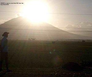
Mount Isarog is a potentially active stratovolcano located in the province of Camarines Sur, Philippines, on the island of Luzon. It has an elevation of 2,000 metres (6,600 ft) above mean sea level.
The peak of the mountain marks the point where the borders of six municipalities and one city meet (listed in clockwise direction, starting north): Goa, Tigaon, Ocampo, Pili, Naga City, Tinambac and Calabanga.
Mount Isarog was where local troops of the Philippine Army and Constabulary units and Bicolano guerrillas hid during the Japanese Occupation. In the 1970s, with the leadership of Romulo Jallores and his brother, they established the New People's Army in the Bicol region at the foot of this mountain.
Wikipedia article: http://en.wikipedia.org/wiki/Mount_Isarog
Nearby cities:
Coordinates: 13°39'26"N 123°23'23"E
- Pocdol Mountains 82 km
- Mount Mariveles 337 km
- Mount Arayat 341 km
- Mount Pinatubo 375 km
- Mount Balatukan 553 km
- Malindang Mountain Range Natural Park 580 km
- Sugarloaf Complex 626 km
- Babuyan Island 678 km
- Leonard Kniaseff Volcano 743 km
- Makian Island 1541 km
- Mount Isarog Crater 0.9 km
- site 5.3 km
- Church of God- Curry 5.5 km
- Ocampo, Camarines Sur 7.1 km
- isidro magdaraog proper 7.2 km
- morokborok 7.5 km
- Rumangrap Spring 7.5 km
- Anayan Spring 7.8 km
- Tigaon, Camarines Sur 8.9 km
- Camarines Sur 14 km
Comments