Zennor Head
United Kingdom /
England /
Penzance /
World
/ United Kingdom
/ England
/ Penzance
World / United Kingdom / England
headland (geography)
Add category


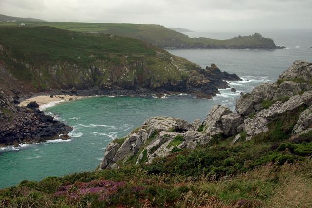
Zennor Head /ˈzɛnʊər hɛd/ is a 750-metre (2,460 ft) long promontory on the Cornish coast of England, between Pendour Cove and Porthzennor Cove. Facing the Atlantic Ocean, it lies 1 kilometre north-west of the village of Zennor and 1.6 kilometres east of the next promontory, Gurnard's Head. The granite (Killas) cliffs rise over 200 feet (60 m) from the sea and the highest point of the headland is 314 feet (96 m) above sea level, with an Ordnance Survey triangulation station. Zennor Head is on the South West Coast Path, which follows the cliff edge closely, skirting the entire perimeter of the headland. The promontory is part of the Penwith Heritage Coast, and is the largest coastal feature in the United Kingdom that begins with the letter "Z". It gets its name from a local saint, Senara. Zennor Head was mined for copper and tin in the Victorian Era. There is no longer any residential or commercial occupancy on the headland, but it is occupied by a variety of coastal animals and plants, such as kestrels and gorse.
Wikipedia article: https://en.wikipedia.org/wiki/Zennor_Head
Nearby cities:
Coordinates: 50°11'54"N 5°34'30"W
- Start Point 136 km
- Portland Bill 224 km
- Hengistbury Head 275 km
- Muntevary or Sheep´s Head (Rinn Mhuintir Bháire) 336 km
- Abermenai Point 338 km
- Crow Head 358 km
- The Great Orme / Y Gogarth 369 km
- Benmore / Fair Head 561 km
- Mull of Kintyre 573 km
- Flamborough Head 574 km
- Pendour Cove 0.5 km
- The Enrico Parodi (Wreck) 2.6 km
- The Saxon Briton (Wreck) 4 km
- Steeple Woods 6.6 km
- Nance Fishing Lakes 7 km
- Tregenna Castle Hotel Golf and Country Club 7.1 km
- Porthminster Beach 7.2 km
- Porthkidney Beach 9 km
- St Ives Bay 10 km
- Cornwall 53 km