Toa Baja
Puerto Rico /
Bayamyn /
Levittown /
World
/ Puerto Rico
/ Bayamyn
/ Levittown
World / Puerto Rico
city, municipality
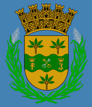


Toa Baja is a municipality of Puerto Rico located in the northern coast, north of Toa Alta and Bayamón; east of Dorado; and west of Cataño. Toa Baja is spread over 5 wards, including Toa Baja Pueblo (The downtown area and the administrative center of the city). It is part of the San Juan-Caguas-Guaynabo Metropolitan Statistical Area.
Toa Baja considered to be a part of the Metropolitan Area. It shares its metropolitan area status with San Juan, Bayamón, Guaynabo, Cataño, Carolina and Trujillo Alto.
Toa Baja is located fifteen minutes by car from San Juan and one hour from Ponce.
Toa Baja considered to be a part of the Metropolitan Area. It shares its metropolitan area status with San Juan, Bayamón, Guaynabo, Cataño, Carolina and Trujillo Alto.
Toa Baja is located fifteen minutes by car from San Juan and one hour from Ponce.
Wikipedia article: http://en.wikipedia.org/wiki/Toa_Baja,_Puerto_Rico
Nearby cities:
Coordinates: 18°25'57"N 66°11'56"W
- Utuado 67 km
- Guayana City 1169 km
- Boa Vista 1823 km
- Calçoene 2359 km
- Amapá 2462 km
- Ferreira Gomes 2531 km
- Cutias 2544 km
- Macapá 2587 km
- Santana 2591 km
- Itaubal 2595 km
- Base desactivada. Sabana Seca South Tract 0.4 km
- Sabana Seca 1.6 km
- Levittown 5th Section 1.9 km
- Sabana Seca 2.1 km
- Candelaria Arenas 2.6 km
- Levittown 2.9 km
- Macún 3 km
- Hato Tejas 3.5 km
- Candelaria 3.8 km
- Media Luna 4.6 km