Appian Way (Rome)
Italy /
Lazio /
Ciampino /
Rome
World
/ Italy
/ Lazio
/ Ciampino
World / Italy / Lazio / Roma
road, interesting place, invisible, do not draw title
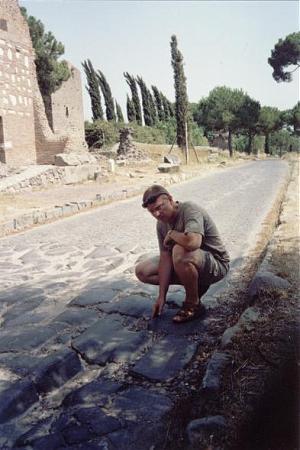
Main road from Rome to the south. Roman law prohibited burials within city limits, so roman people were buried along the sides of roads, where their monuments could be admired by travelers.
Aside from the burial sites, it is a fine example of Roman road engineering, and easily accessible from Rome.
Aside from the burial sites, it is a fine example of Roman road engineering, and easily accessible from Rome.
Wikipedia article: http://en.wikipedia.org/wiki/Via_Appia
Nearby cities:
Coordinates: 41°50'34"N 12°31'49"E
- Citta di aria 137 km
- Roman Rd Via Annia 415 km
- Roman Rd Via Cloudia Augusta 426 km
- Roman Rd Via Annia 427 km
- Kotor Serpentine 519 km
- Loibl (Ljubelj) Road Tunnel 530 km
- New Boulevard (former Tirana railway station) 608 km
- Rruga e Zhedenit Kopanices 717 km
- Andrássy Avenue - UNESCO World Heratage Site 815 km
- Revolution Boulevard (The City Center) 852 km
- Appio-Pignatelli 0.9 km
- "Acquasanta" Golf Club 1.3 km
- Ardeatino 2 km
- Municipio Roma XI 2.1 km
- Caffarella Park 2.3 km
- Archi di Claudio Golf Club 2.7 km
- Appio Claudio Park 2.7 km
- "Francesco Baracca" Air Base of Rome-Centocelle 3.7 km
- Torre Spaccata 4.8 km
- Municipio VII 6.2 km