Bosworth Battlefield Heritage Country Park (site of Battle of Bosworth)
United Kingdom /
England /
Stoke Golding /
World
/ United Kingdom
/ England
/ Stoke Golding
World / United Kingdom / England
battlefield, parkland
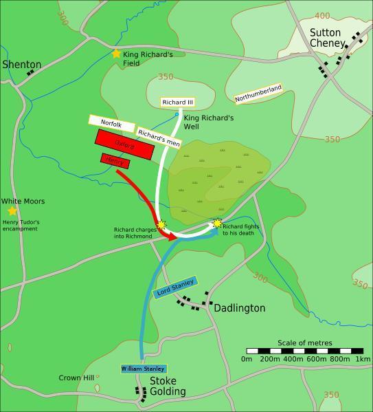
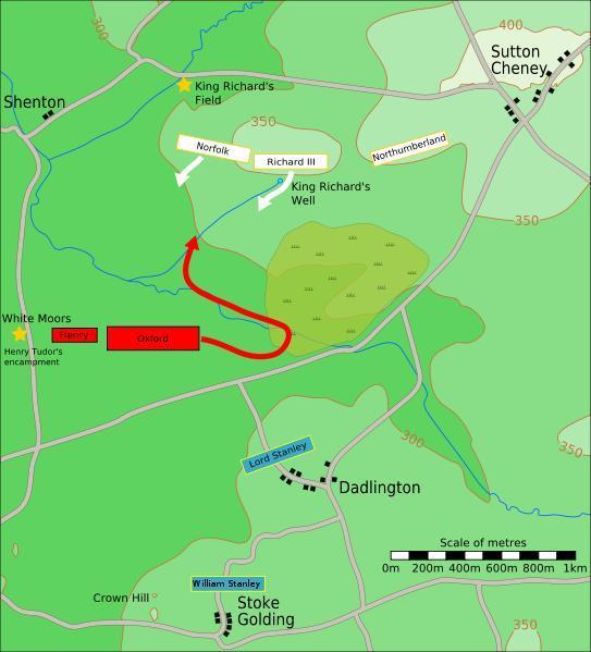
The Battle of Bosworth or Bosworth Field was an important battle during the Wars of the Roses in 15th century England. It was fought on 22 August 1485 between the Yorkist King Richard III, the last of the Plantagenet dynasty, and the Lancastrian contender for the crown, Henry Tudor, 2nd Earl of Richmond (later King Henry VII). It ended in the defeat and death of Richard and the establishment of the Tudor dynasty.
The Country Park was developed in the early 1970’s to provide an environment to interpret the famous Battle of Bosworth. The boundaries of the Country Park do not necessarily represent the expanse of the historic battle.
www.bosworthbattlefield.com/visit/country.htm
www.leics.gov.uk/country_parks_bosworth
Image source:en.wikipedia.org/wiki/Battle_of_Bosworth_Field
©Jappalang commons.wikimedia.org/wiki/User:Jappalang
Wikipedia article: http://en.wikipedia.org/wiki/Battle_of_Bosworth
Nearby cities:
Coordinates: 52°35'39"N 1°24'6"W
- Aqualate Park 68 km
- Madresfield Park 79 km
- Gatton Park 170 km
- Birkrigg Common 208 km
- Willoughby River Forest 5048 km
- Salamonie River State Forest 6190 km
- Yellowwood State Forest 6351 km
- Morgan-Monroe State Forest 6353 km
- Black Hills National Forest 6999 km
- Medison Bow National Forest 7300 km
- Oaktree Farm 4.6 km
- Caterpillar Logistics Services Ltd. 7.7 km
- Bagworth and Thornton Parish 10 km
- Sense Valley Park 12 km
- Bardon Industrial Estate 12 km
- Leicester Forest East 12 km
- Martinshaw woods 13 km
- Bradgate Park 17 km
- The National Forest 18 km
- Warwickshire 33 km
Comments