Devils River State Natural Area
USA /
Texas /
Del Rio /
World
/ USA
/ Texas
/ Del Rio
World / United States / Texas
park, nature reserve, animal sanctuary

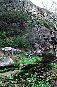
The park's large size and remoteness support day hiking, primitive camping, nature study, mountain biking, and canyon tours. Access to the river (1.5 miles) is by hiking, biking, or park tour only; no vehicle access permitted. The park is a put-in point (no take out) for canoes and kayaks. Nearest take out point is about 10 miles downriver from the Park and only outfitters are allowed to take boats out on these private lands. Lake Amistad is about 32 miles downriver from the Park, no cost to take boat out there. Catch and release fishing only. No live bait is permitted. No boats or motorized watercraft are allowed, only canoes or kayaks are allowed in the water. This is a FLASH FLOOD AREA, exercise caution. The nearest hospital is 70 miles away. Only containerized fuel fires allowed.
Before visiting, please check out the following web site for dangers:
www.tpwd.state.tx.us/spdest/findadest/parks/devils_rive...
Before visiting, please check out the following web site for dangers:
www.tpwd.state.tx.us/spdest/findadest/parks/devils_rive...
Wikipedia article: http://en.wikipedia.org/wiki/Texas_state_parks
Nearby cities:
Coordinates: 29°56'11"N 100°56'42"W
- Amistad National Recreation Area 42 km
- Kickapoo Cavern State Park 56 km
- State Natural Area 79 km
- Lost Maples State Natural Area 130 km
- San Angelo State Park 176 km
- Government Canyon State Natural Area 211 km
- Enchanted Rock State Natural Area 213 km
- Lyndon B. Johnson National Historical Park / ranch unit 224 km
- Guadalupe River State Park 235 km
- Colorado Bend State Park 264 km
- TS04 Rio Vista Ranch Airport 11 km
- Iverson Devil's River Ranch 15 km
- Baker's Crossing on the Devil's River 20 km
- 4TE7 Devil's River Ranch Airport 22 km
- Rocksprings Wind Farm 25 km
- Twin Canyons 37 km
- Highway Border Inspection Station (under construction) 38 km
- Eskew Bosch Ranch 38 km
- Rough Canyon 40 km
- Lake Amistad 46 km