Flying Tiger Line Flight 282 Crash Site
USA /
California /
Pacifica /
World
/ USA
/ California
/ Pacifica
World / United States / California
United States Coast Guard, aircraft crash site

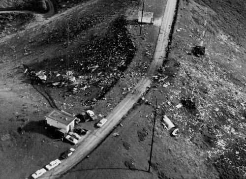
On 23 Dec 1964, Flying Tiger Line Constellation N6915C crashed here due to pilot error during poor weather conditions. The plane struck the eastern side of Sweeney's Ridge, bounced back into the air, and landed on the other side of the ridge. The crash killed all three personnel aboard instantly. Additionally, the crash destroyed three of the nearby USCG radio station's transmitter buildings, emergency turbine generator transformers, and a pair of radio antenna. Crash debris can still be found, including parts of the plane and some of the costume beads cargo bound for New York.
www.check-six.com/Crash_Sites/Flying_Tiger_282.htm
www.check-six.com/Crash_Sites/Flying_Tiger_282.htm
Wikipedia article: http://en.wikipedia.org/wiki/Flying_Tiger_Line_Flight_282
Nearby cities:
Coordinates: 37°37'25"N 122°27'54"W
- Lake Mead B-29 Crash Site 732 km
- United Flight 232 Crash Site 2276 km
- 1961 Goldsboro B-52 Crash Site and Debris Field 3958 km
- Approximate Location of TWA Flight 800 Crash Site 4257 km
- 1968 B-52 crash site 5035 km
- Approximate Crash Site Birgenair 757 Flight 301 February 6,1996 5367 km
- B-29 "Kee Bird" Wreckage 5381 km
- Air India Flight 182 8024 km
- 1966 Palomares B-52 crash 9711 km
- crash area 11536 km
- Vallemar 1.8 km
- Sharp Park Golf Club 1.9 km
- Golden Gate National Cemetery 3.3 km
- California Golf Club of San Francisco 3.5 km
- Back of the Valley 3.8 km
- San Andreas Lake 4.6 km
- San Bruno faults - Daly City 5 km
- SFPUC Peninsula Watershed 11 km
- San Francisco Bay 19 km
- San Andreas Fault Zone 102 km