Tahkenitch Lake
USA /
Oregon /
Dunes City /
World
/ USA
/ Oregon
/ Dunes City
World / United States / Oregon
fishing area, lake
The story of Tahkenitch Lake begins over 8,000 + years ago. As one of the most studied archaeological sites on the Central Oregon coast, this lake tells a very fascinating story of human forest management. Native American Indian villages and activity site artifacts, date back over 8,000 years. These natives actively used fire around the lake and surrounding area as a management tool. It is thought this type of forest management was used to keep the areas around the lake open and grass-covered to promote deer and elk grazing, within easy access to their encampments along the shore.
While Tahkenitch is now a lake, it is believed to have actually been an ocean estuary about 3000 - 4000 years ago. Due to large earthquakes at this time, sudden dunal activity shifted, cutting it off from the Pacific Ocean, now about 1.6 miles away. There is a tremendous amount of evidence to support this.
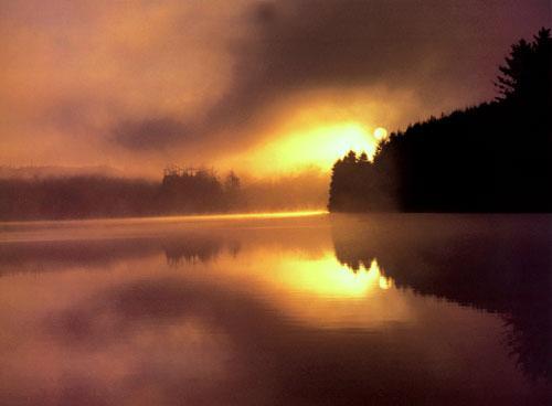
What you see today in the early morning fog & silhouettes of trees, are primarily Douglas-firs, shore pine, Sitka spruce and some hemlocks. The areas around the lake have been harvested at least once, some private ownership areas twice, and some areas are actually ready for a third harvesting within the last 150 years of white man's tenure in management.
What is truly amazing, through pollen studies and fire frequency research, is that the forest you see, actually represents something over the 200th managed forest to occupy these shores over the last 8,000 - 10,000 years. Obviously long term forest management can work, with no lasting harm to the Eco-system or the soils ability to produce. In order to provide for Sustainable Eco-systems, we must manage our resources wisely.
While Tahkenitch is now a lake, it is believed to have actually been an ocean estuary about 3000 - 4000 years ago. Due to large earthquakes at this time, sudden dunal activity shifted, cutting it off from the Pacific Ocean, now about 1.6 miles away. There is a tremendous amount of evidence to support this.
What you see today in the early morning fog & silhouettes of trees, are primarily Douglas-firs, shore pine, Sitka spruce and some hemlocks. The areas around the lake have been harvested at least once, some private ownership areas twice, and some areas are actually ready for a third harvesting within the last 150 years of white man's tenure in management.
What is truly amazing, through pollen studies and fire frequency research, is that the forest you see, actually represents something over the 200th managed forest to occupy these shores over the last 8,000 - 10,000 years. Obviously long term forest management can work, with no lasting harm to the Eco-system or the soils ability to produce. In order to provide for Sustainable Eco-systems, we must manage our resources wisely.
Nearby cities:
Coordinates: 43°48'2"N 124°7'13"W
- Sugar Lake 852 km
- Monashee Provincial Park 873 km
- Hebgen Lake 1024 km
- Shoshone Lake 1066 km
- Yellowstone Lake 1083 km
- Fremont Lake 1157 km
- Angostura Resevior 1661 km
- Duck Mountain Provincial Park 1880 km
- Fort Pierre National Grassland 1886 km
- Calamus State Recreation Area & Calamus Reservoir 2025 km
- Oregon Dunes National Recreation Area (South) 5.2 km
- Siltcoos Lake 8.5 km
- Woahink Lake 13 km
- Winchester Bay, Oregon 15 km
- Oregon Dunes National Recreation Area (North) 16 km
- Wassen Creek roadless area 20 km
- Eel Lake 21 km
- North Tenmile Lake 23 km
- Mercer Lake 29 km
- Mapleton, Oregon 33 km