The Crofoot Block (Pontiac, Michigan)
USA /
Michigan /
Pontiac /
Pontiac, Michigan
World
/ USA
/ Michigan
/ Pontiac
World / United States / Michigan
place with historical importance, night club

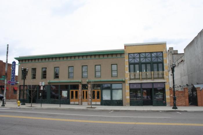
Now known as "The Crofoot", a dining and entertainment establishment. Most of the current structure was built in 1882 and housed various businesses including the offices of Judge Michael E. Crofoot for whom the block is named.
Wikipedia article: http://en.wikipedia.org/wiki/The_Crofoot
Nearby cities:
Coordinates: 42°38'11"N 83°17'29"W
- Geographic Township of Maidstone (former) 49 km
- Geographic Township of Colchester North (former) 57 km
- Geographic Township of Rochester (former) 59 km
- Geographic Township of Malden (former) 60 km
- Geographic Township of Gosfield North (former) 64 km
- Geographic Township of Colchester South (former) 65 km
- Geographic Township of Sombra (former) 66 km
- Geographic Township of Tilbury North (former) 67 km
- Geographic Township of Gosfield South (former) 70 km
- Geographic Township of Tilbury West (former) 71 km
- Franklin Boulevard Historic District 0.8 km
- M1 Concourse 1.6 km
- Lakeside Housing 1.7 km
- Crystal Lake 1.9 km
- Seminole Hills Historic District 1.9 km
- Pontiac Municipal Golf Course 2.1 km
- Beaudette Park 2.7 km
- Saint Joseph Hospital 2.7 km
- CNR (former GTW Pontiac Yard) 2.9 km
- Bloomfield Township, Michigan 6.4 km