San Juan River Bridge (Manila)
Philippines /
National Capital Region /
Manila /
Old Santa Mesa
World
/ Philippines
/ National Capital Region
/ Manila
World / Philippines / Metropolitan Manila / San Juan
battlefield, place with historical importance, interesting place, road bridge
Km. 006 + 070.70
Length:
Load limit: 10 tons
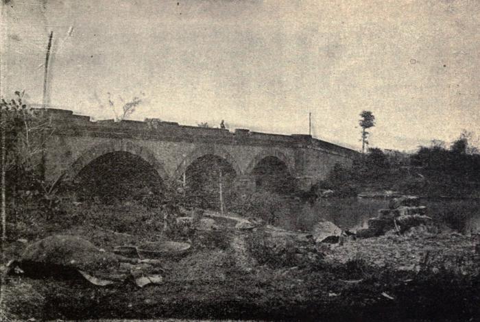
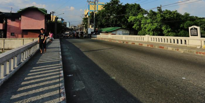
The San Juan River Bridge (Filipino: Tulay ng Ilog San Juan), also known as San Juan del Monte Bridge, is a boundary bridge between the city of San Juan and Santa Mesa, one of the sixteen (16) areas of Manila, Philippines. The 40-meter bridge connects the N. Domingo Street in San Juan and Old Santa Mesa Street in Manila.
Became a battlefield in both the 1896 Revolution against the Spaniards and in the Filipino-American War in 1899.
The First Shot of the Philippine-American War was said to have been fired here, with most of us being taught that information in school and in textbooks. But that has been corrected several years ago by the National Historical Institute, stating that the correct location was in the corner of Silencio and Sociego Streets located in Sta. Mesa, Manila.
The corrected location can be found here, and is validated by the two commemorative-markers placed on the site:
wikimapia.org/#lat=14.603648&lon=121.0135567&z=18&l=0&...
And the new name of this bridge can be found here:
www.sanjuancity.gov.ph/?page_id=13139
Label at the end of the bridge: "Old Sta. Mesa Bridge" (San Juan side)
Length:
Load limit: 10 tons
The San Juan River Bridge (Filipino: Tulay ng Ilog San Juan), also known as San Juan del Monte Bridge, is a boundary bridge between the city of San Juan and Santa Mesa, one of the sixteen (16) areas of Manila, Philippines. The 40-meter bridge connects the N. Domingo Street in San Juan and Old Santa Mesa Street in Manila.
Became a battlefield in both the 1896 Revolution against the Spaniards and in the Filipino-American War in 1899.
The First Shot of the Philippine-American War was said to have been fired here, with most of us being taught that information in school and in textbooks. But that has been corrected several years ago by the National Historical Institute, stating that the correct location was in the corner of Silencio and Sociego Streets located in Sta. Mesa, Manila.
The corrected location can be found here, and is validated by the two commemorative-markers placed on the site:
wikimapia.org/#lat=14.603648&lon=121.0135567&z=18&l=0&...
And the new name of this bridge can be found here:
www.sanjuancity.gov.ph/?page_id=13139
Label at the end of the bridge: "Old Sta. Mesa Bridge" (San Juan side)
Wikipedia article: https://en.wikipedia.org/wiki/San_Juan_River_Bridge
Nearby cities:
Coordinates: 14°36'5"N 121°1'12"E
- Pandacan Bridge (Zamora Bridge) 1.1 km
- Mabini Bridge (Nagtahan Bridge) 2.1 km
- Ayala Bridge 3.9 km
- Quezon Bridge 4.2 km
- M. Roxas Jr. Bridge 5.9 km
- C. P. Garcia Bridge 6.6 km
- Kaginhawaan Bridge 6.6 km
- North-South Harbor Bridge (U.C.) 6.7 km
- Bambang Bridge 7.9 km
- Ponteverde/PNR Bridge 54 km
- NHA Compound 0.2 km
- SM City Santa Mesa 0.3 km
- Main Building 0.3 km
- Landcom Village 0.4 km
- ATI Sta. Mesa Container Yard 0.4 km
- Morningside Terrace Subdivision 0.7 km
- Buddhist Tzu Chi Campus 0.9 km
- Santa Mesa 0.9 km
- Simon Enterprises, Inc. 1 km
- Pandacan 1.9 km