F3 Tornado path (St. Peter, Minnesota)
USA /
Minnesota /
Kasota /
St. Peter, Minnesota
World
/ USA
/ Minnesota
/ Kasota
World / United States / Minnesota
tornado, interesting place, historical layer / disappeared object
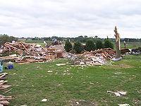
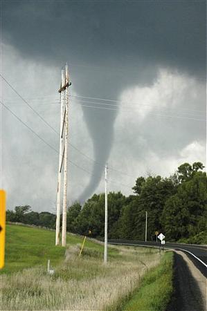

While not visible in the current imagery, This is the path of a F3 tornado in 2006, traveling west-east across the river before devastating the city of Kasota. All of the trees in this swath were severely damaged or toppled, providing an awe-inspiring sight when driving along Hwy 169.
Nearby cities:
Coordinates: 44°18'2"N 93°58'42"W
- Tornado Damage Swath - June 7, 2007 407 km
- 2011 Tornado Track 806 km
- Path of May 31 2013 El Reno Tornado 1038 km
- Path of 2011 Tuscaloosa Tornado 1352 km
- Path of EF2 Tornado - April 15, 2019 1650 km
- Path of the First Tornado of the 2007 Groundhog Day Outbreak 2014 km
- Path of the Second Tornado of the 2007 Groundhog Day Outbreak 2026 km
- Path of the Third Tornado of the 2007 Groundhog Day Outbreak 2050 km
- Belyanitsy 8000 km
- Former Annehof Forest 8010 km
- Kasota Township, Le Sueur County, Minnesota 1.1 km
- Kasota Limestone Mine 2.5 km
- East Minnesota River State Game Refuge 5.9 km
- Seven Mile Creek County Park 6 km
- Ottawa WMA 6.8 km
- Wita Lake 10 km
- Lake Washington 10 km
- Mankato Regional Airport (MKT/KMKT) - Mankato, MN 10 km
- Washington Township, Le Sueur County, Minnesota 10 km
- Cleveland Township, Le Sueur County, Minnesota 12 km
Kasota Township, Le Sueur County, Minnesota
Kasota Limestone Mine
East Minnesota River State Game Refuge
Seven Mile Creek County Park
Ottawa WMA
Wita Lake
Lake Washington
Mankato Regional Airport (MKT/KMKT) - Mankato, MN
Washington Township, Le Sueur County, Minnesota
Cleveland Township, Le Sueur County, Minnesota