Chota Memorial
USA /
Tennessee /
Greenback /
World
/ USA
/ Tennessee
/ Greenback
World / United States / Tennessee
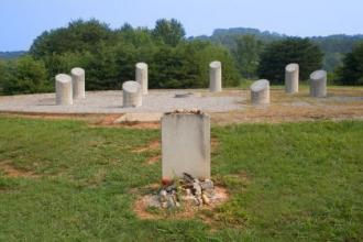
Along the Little Tellico River lies Chota Memorial, a full scale representation of the townhouse, or council house, originally erected by the Eastern Band of the Cherokee Indians. The memorial sits in the same location as the original structure. The structure was used for public ceremonies and social events.
Archaeological studies indicate that another building or pavilion stood adjacent to the townhouse. This building was an open rectangular building which was used for the same reasons during warm weather.
Historical references suggest that Chota was, at one time, the largest Cherokee town in the region, with an estimated population of 300 to 500. Many references go on to suggest that around 1730, Chota became the new Cherokee capital, a title formerly held by the nearby town of Tanasi.
Chota was destroyed in 1780 by American forces during the Revolutionary War. Although Chota was rebuilt in 1784, it never fully recovered.
In 1788, the Cherokee capital officially moved to Ustanalli, located in North Georgia.
By 1807, Chota's population had dwindled to a mere 30, and by 1813, only a single household remained in Chota.
www.tennesseerivervalleygeotourism.org/content/chota-me...
Nearby cities:
Coordinates: 35°33'32"N 84°7'58"W
- Cook's Hollow 2.8 km
- Maryville Industrial Park 25 km
- Rarity Pointe 25 km
- Loudon, Tennessee 30 km
- Sequoyah Hills 45 km
- Oak Ridge National Laboratory 46 km
- Cherokee Farm 46 km
- US Dept. of Energy Nuclear waste landfill 49 km
- spam 49 km
- Forks of the River Wildlife Management Area 51 km
- Harbour Place 6.2 km
- McGhee-Carson Peninsula 6.4 km
- Tellico Lake Historic Fort, Museum and Resort Area 7.9 km
- The Links at Kahite 10 km
- Rarity Bay 14 km
- Citico Creek Wilderness area 15 km
- Jackson Bend 16 km
- Sequoyah High School 17 km
- Summer Oaks 20 km
- William Blount High School 22 km