Pillar Point Air Force Station
| Second World War 1939-1945, military, radar station, United States Air Force
USA /
California /
El Granada /
World
/ USA
/ California
/ El Granada
World / United States / California
Second World War 1939-1945, military, radar station, United States Air Force

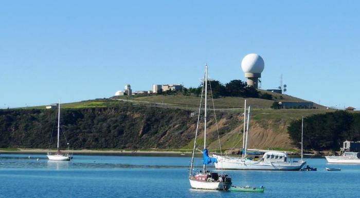
The California Coast has few protective points. Pillar Point is one of them. The Point at night with its string of lights looks like the largest battleship in the American fleet. On top of the point is the Pillar Point Air Force Station. Beneath the tracking station is the harbor. It is the only harbor between San Francisco and Santa Cruz. This natural harbor has been used by coastal fishermen for centuries, but the harbor, with its tracings of rip-rap breakwaters, was first constructed in 1961. The inner breakwater was added in 1982.
On 10 October 1940, the U.S. Army purchased almost 50 acres of land for a military reservation. The site was known as Pillar Point Military Reservation (Harbor Defense of San Francisco), California and was used as a harbor defense facility and primary artillery site for the City of San Francisco. The improvements constructed at Pillar Point consisted of barracks, concrete bunkers, cyclone fences, and an overhead and underground electric system.
Starting on 30 November 1949, leases on various parcels of land were gradually terminated until 1959 when what was left was transferred to the Department of the Navy for use as a radar facility. In the early 1960s, over 12 acres of the original Army acreage were transferred to the U.S. Air Force and a missile tracking installation was established on the site. The property owned by the U.S. Air Force continues to be used as part of the missile tracking installation. Four of the remaining seven acres are currently owned by the San Mateo Harbor District and are being developed into a wetlands habitat. The remaining three acres are privately owned and undeveloped.
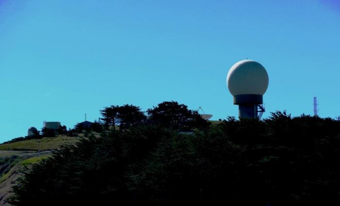
The Pillar Point AN/FPQ-6 and AN/MPS-36 radars are highly accurate C-band radars owned by the Vandenberg Air Force Base's Western Range (WR). These radars can be used for tracking objects off the coast of central California.
www.militarymuseum.org/PointPillarAFS.html
www.globalsecurity.org/space/facility/pillar-point.htm
On 10 October 1940, the U.S. Army purchased almost 50 acres of land for a military reservation. The site was known as Pillar Point Military Reservation (Harbor Defense of San Francisco), California and was used as a harbor defense facility and primary artillery site for the City of San Francisco. The improvements constructed at Pillar Point consisted of barracks, concrete bunkers, cyclone fences, and an overhead and underground electric system.
Starting on 30 November 1949, leases on various parcels of land were gradually terminated until 1959 when what was left was transferred to the Department of the Navy for use as a radar facility. In the early 1960s, over 12 acres of the original Army acreage were transferred to the U.S. Air Force and a missile tracking installation was established on the site. The property owned by the U.S. Air Force continues to be used as part of the missile tracking installation. Four of the remaining seven acres are currently owned by the San Mateo Harbor District and are being developed into a wetlands habitat. The remaining three acres are privately owned and undeveloped.
The Pillar Point AN/FPQ-6 and AN/MPS-36 radars are highly accurate C-band radars owned by the Vandenberg Air Force Base's Western Range (WR). These radars can be used for tracking objects off the coast of central California.
www.militarymuseum.org/PointPillarAFS.html
www.globalsecurity.org/space/facility/pillar-point.htm
Wikipedia article: http://en.wikipedia.org/wiki/Western_Launch_and_Test_Range
Nearby cities:
Coordinates: 37°29'51"N 122°29'52"W
- Camp Stoneman (site) 77 km
- Skaggs Island 79 km
- Camp Beale (site) 213 km
- Camp Essex - Desert Training Center/California-Arizona Maneuver Area (site) 713 km
- Camp Clipper (site) 716 km
- Borrego Valley Manuever Area 718 km
- Camp Iron Mountain (site) 760 km
- Camp Granite (site) 763 km
- Poston War Relocation Center 822 km
- Los Alamos National Laboratory 1450 km
- Princeton by the Sea, California 1.1 km
- Pillar Point Harbor 1.1 km
- Fitzgerald Marine Reserve 2.1 km
- El Granada, California 2.4 km
- Moss Beach, California 2.7 km
- Half Moon Bay State Beach 3.7 km
- Wavecrest Open Space 7.7 km
- The Old Course - Half Moon Bay Golf Links 8.8 km
- SFPUC Peninsula Watershed 11 km
- San Andreas Fault Zone 94 km