RMS Queen Mary
| hotel, museum, ship, historic landmark
USA /
California /
Long Beach /
Queens Highway, 1126
World
/ USA
/ California
/ Long Beach
World / United States / California
hotel, museum, ship, historic landmark


1126 Queens Highway
Long Beach, CA 90802
(562) 435-3511
www.queenmary.com/
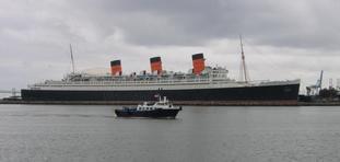
The RMS Queen Mary was a Cunard Line (then Cunard White Star Line) ocean liner that sailed the North Atlantic Ocean from 1936 to 1967. Built by John Brown and Company, Clydebank, Scotland, she was designed to be the first of Cunard's planned two-ship weekly express service from Southampton to New York, in answer to the mainland European super-liners of the late twenties and early thirties.
Queen Mary and her slightly larger and younger running mate RMS Queen Elizabeth commenced this two-ship service after their release from World War II troop transport duties and continued it until for two decades until Queen Mary's retirement in 1967 as a tourist attraction.
Hundreds of films and television shows have filmed aboard, including "The Poseidon Adventure," which shot many pre-capsizing scenes in 1972.
Long Beach, CA 90802
(562) 435-3511
www.queenmary.com/
The RMS Queen Mary was a Cunard Line (then Cunard White Star Line) ocean liner that sailed the North Atlantic Ocean from 1936 to 1967. Built by John Brown and Company, Clydebank, Scotland, she was designed to be the first of Cunard's planned two-ship weekly express service from Southampton to New York, in answer to the mainland European super-liners of the late twenties and early thirties.
Queen Mary and her slightly larger and younger running mate RMS Queen Elizabeth commenced this two-ship service after their release from World War II troop transport duties and continued it until for two decades until Queen Mary's retirement in 1967 as a tourist attraction.
Hundreds of films and television shows have filmed aboard, including "The Poseidon Adventure," which shot many pre-capsizing scenes in 1972.
Wikipedia article: http://en.wikipedia.org/wiki/RMS_Queen_Mary
Nearby cities:
Coordinates: 33°45'10"N 118°11'23"W
- Wreck of USS Independence (CVL-22) 610 km
- Lake Oroville Marina 725 km
- Naval Submarine Base Bangor 1606 km
- Montague Harbour 1740 km
- ESCO Marine Inc. 2183 km
- International Shipbreaking Limited 2184 km
- SEAFAC Static Site surface barges 2646 km
- Battleship Row 4130 km
- Wreck of USS Nevada (BB-36) 4241 km
- Wreck of USS Belleau Wood (LHA-3) 4277 km
- International Transportation Service, Inc 0.8 km
- Long Beach Shoreline Marina 0.9 km
- Queensway Bay 1 km
- Southeast Basin 1.4 km
- Downtown Long Beach 1.6 km
- Pacific Container Terminal 1.7 km
- Basin Six 2 km
- Long Beach Container Terminal (LBCT) 2.3 km
- Los Angeles-Long Beach Port Complex 4.5 km
- Los Angeles County, California 58 km
Comments