Wellesbourne Mountford Airfield
United Kingdom /
England /
Wellesbourne /
Loxley Lane
World
/ United Kingdom
/ England
/ Wellesbourne
World / United Kingdom / England
airport, Second World War 1939-1945, military, RAF - Royal Air Force, closed / former military, former air force base
former RAF Wellesbourne Mountford.
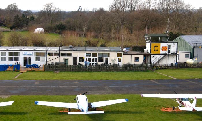
Wellesbourne Mountford Airfield (ICAO:EGBW) is located in Wellesbourne, Warwickshire, England, 3.3 NM (6.1 km; 3.8 mi) east of Stratford-Upon-Avon. The airfield was formerly the Royal Air Force station RAF Wellesbourne Mountford.Wellesbourne Mountford is best known for its role in the Second World War, when it was under control by RAF Bomber Command as a Operational Training Unit training crews from within the commonwealth and other countries.
Today the airfield has a CAA Ordinary Licence (Number P681) that allows flights for the public transport of passengers or for flying instruction as authorised by the licensee (Radarmoor Limited). It is primarily a general aviation (GA) airfield; see UKGA for details. Wellesbourne Mountford is also home to Avro Vulcan XM655, which is kept in a taxiable conditions.
Royal Air Force use
The airfield was originally opened in 1941 constructed in the typical Class A airfield design, The main unit to use the airfield was No. 22 Operational Training Unit which flew Vickers Wellingtons and Avro Ansons for RAF Bomber Command. During the Second World War the airfield was attacked a few times by enemy bombers on their way home after bombing targets in the Midlands such as Coventry and Birmingham.
The nearby Ettington railway station was used to transport troops and munitions from the rest of the country then to the airfield using RAF lorries and buses. Crews also attacked a number of German cities such as Cologne, Essen and Bremen as part of the 1,000 bomber raids. The aircraft were crewed by instructors and students with some planes unfortunately failing to return. The airfield briefly was home to the No.3 Glider Training School during July 1945 preparing for war in the far east using the General Aircraft Hotspur, the RAF School of Photography from 1948 to 1964, the RAF School of Education 1950 to 1952 and the Airfield Construction Branch from 1951 to 1964. In 1964 the airfield was closed and put on a care and maintenance basis then returned to the original owners.
www.wellesbourneairfield.com
Wikipedia article: http://en.wikipedia.org/wiki/Wellesbourne_Mountford_Airfield
Nearby cities:
Coordinates: 52°11'23"N 1°36'43"W
- RAF Brize Norton 47 km
- RAF Fairford 56 km
- Former RAE Bedford /RAF Thurleigh 77 km
- RAF Wittering 89 km
- Alconbury Developments Limited (Former RAF Alconbury) 95 km
- London Heathrow Airport (LHR/EGLL) 110 km
- Manchester International Airport (IATA: MAN, ICAO: EGCC) 140 km
- Dublin Airport 345 km
- Belfast International Airport 412 km
- Glasgow Prestwick Airport 420 km
- M40 Distribution Park 0.3 km
- Wellesbourne Wood 1.3 km
- Charlecote Park 1.9 km
- Smatchley Wood 2.1 km
- Stratford-on-Avon Golf Club 4.9 km
- Stratford Racecourse 7.7 km
- Barford Wood 8 km
- Lodge Wood 8.4 km
- Stratford Oaks Golf Club 9 km
- Warwickshire 14 km