Yaxchilan
Mexico /
Tabasco /
Miguel Hidalgo /
World
/ Mexico
/ Tabasco
/ Miguel Hidalgo
World / Guatemala / Petén
ruins, archaeological site, Maya civilization, ancient ruins


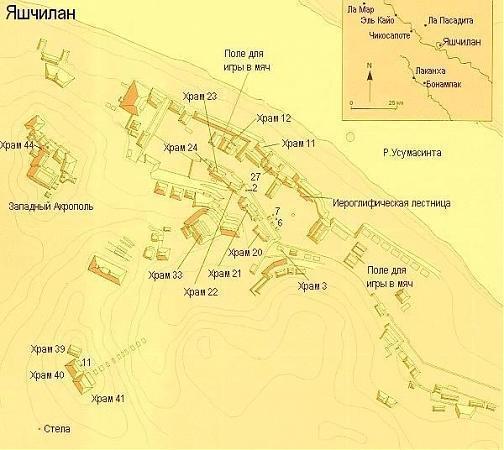
Yaxchilan, located on the banks of the Usumacinta River in the Yucatán peninsula of Mexico, was an important Late Classic Maya centre. Yaxchilan flourished between c. 580 and c. 800 CE, benefitting from commerce via the Usumacinta River and trading in copal resin and dyes processed from Brazil wood. Remains of stone pilings suggest the site once had a bridge or toll gate. Impressive in both architecture and sculpture, the site displays evidence of warfare before its collapse in the 9th century CE.
www.youtube.com/watch?v=lDlNIa1lwbc
Yaxchilan was a Maya settlement inhabited between 200AD and 800AD, which rose to prominence in the 8th century. It is currently reachable only by river or by air.
See: www.raingod.com/angus/Gallery/Photos/NorthAmerica/Mexic...
See also: mesoamerica.narod.ru/fotoyax.html
Wikipedia article: http://en.wikipedia.org/wiki/Yaxchilan
Nearby cities:
Coordinates: 16°53'50"N 90°57'58"W
- Archaeological site of La Joyanca 57 km
- Aguateca 93 km
- Site Q/El Corona archeological site 94 km
- Aguada Fénix 104 km
- Izapa pre-Columbian Archaeological Site 255 km
- San Lorenzo 419 km
- Teotihuacan 890 km
- Tamtoc archeological site 997 km
- Culiacan Mountain 1127 km
- Angamuco (Mayan city) 1154 km
- Monumento Natural Bonampak 25 km
- Montes Azules Biosphere Reserve 45 km
- Archaeological site of La Joyanca 57 km
- Laguna San Diego 59 km
- Laguneta La Gloria 63 km
- Xan Oil Field 72 km
- Maya Biosphere Reserve 86 km
- Site Q/El Corona archeological site 94 km
- Laguna Sacpuy 100 km
- Aguada Fénix 103 km