Januária
| city
Brazil /
Minas Gerais /
Januaria /
World
/ Brazil
/ Minas Gerais
/ Januaria
World / Brazil / Minas Gerais / Januária
city
Add category


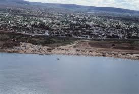

Januária, known as "The Queen of the Beautiful Waters"" is a city and municipality in northern Minas Gerais state, Brazil. It is located on the left bank of the São Francisco River. The estimated population is more than 86,000 inhabitants and the area of the municipality is 7.325 km².
With an elevation of 454.87 meters the average annual temperature is 26º. Temperatures vary between maximums of 38º and 12.6º. The climate is tropical with transition to semi-arid and its vegetation is composed of cerrado (savanna) and clusters of caatinga (thorn bush). The size of the municipality ranks it among the 75 largest municipalities of the state of Minas Gerais.
The most important route of communication with the rest of the state is the BR-135. A modern bridge has substituted the ferry on the river. The distance to Belo Horizonte, the state capital, is 613 km.
Januária lies in an agro-pastoral region. Some changes have been implemented in recent years. Irrigationn, soybean cultivation, and the decline of cotton cultivation are some of them.
Wikipedia article: http://en.wikipedia.org/wiki/Januária
Nearby cities:
Coordinates: 15°28'23"S 44°22'4"W
- Montes Claros 104 km
- Ubaí - Minas Gerais - Brasil 109 km
- Campo Azul - Minas Gerais - Brasil 120 km
- Ponto Chique - Minas Gerais - Brasil 135 km
- Barra do Choça - Bahia - Brasil 402 km
- iguaí 459 km
- lajedo do tabocal 488 km
- Muritiba 519 km
- Ubaíra 556 km
- Pé de Serra 653 km
- dead people place 0.6 km
- Runway 08/26 1.8 km
- Campo de Futebol 2.6 km
- Ponte Rodoviária 14 km
- Cemetery 15 km
- River 34 km
- Princesa Izabel Square 48 km
- Cemetery 48 km
- River Pandeiros Januária MG 57 km
- Electrical substation 71 km