All Saints' Church, Bawdeswell (Bawdeswell)
United Kingdom /
England /
North Elmham-Swanton Morley Airfield /
Bawdeswell /
The Street
World
/ United Kingdom
/ England
/ North Elmham-Swanton Morley Airfield
church, Georgian (architecture), Grade II Listed (UK)
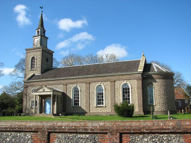
A Grade II listed building. There has been a parish church on this site since circa 1100. All Saints is believed to be the only Norfolk village church destroyed in World War II, having been hit by an RAF Mosquito bomber from 608 Squadron at RAF Downham Market that crashed in the village in November 1944. The Church was replaced with one of Neo-Georgian design by architect J Fletcher Watson in 1953-55.
www.achurchnearyou.com/church/19459/
www.heartofnorfolkchurches.org.uk/our-churches/bawdeswe...
britishlistedbuildings.co.uk/101376613-church-of-all-sa...
Photo from www.geograph.org.uk/photo/4435781
www.achurchnearyou.com/church/19459/
www.heartofnorfolkchurches.org.uk/our-churches/bawdeswe...
britishlistedbuildings.co.uk/101376613-church-of-all-sa...
Photo from www.geograph.org.uk/photo/4435781
Nearby cities:
Coordinates: 52°44'49"N 1°1'51"E
- Roman Catholic Shrine of Our Lady of Walsingham 19 km
- Anglican Shrine of Our Lady of Walsingham 20 km
- Walsingham Abbey 20 km
- Norwich Cathedral 22 km
- St Nicholas Church 23 km
- St. Leonard Church 37 km
- St Edmund's Church, Southwood 38 km
- Grand or St Laurence Church 251 km
- Waarland - Roman Catholic Church of St. Wulfram 256 km
- RK-church 260 km
- Robertson Barracks 4.6 km
- Pensthorpe Nature Reserve (Home of BBC Springwatch) 12 km
- Starmoor Woods 13 km
- Colkirk C.P. 13 km
- Former RAF Little Snoring 15 km
- West Raynham Solar Power Plant 20 km
- Former RAF West Raynham 20 km
- RAF Sculthorpe 21 km
- Industrial Estate 23 km
- North Creake Airfield Solar Power Plant 23 km