Site of the White Terraces.
New Zealand /
Waikato /
Reporoa /
World
/ New Zealand
/ Waikato
/ Reporoa
World / New Zealand / Bay of Plenty / Rotorua
historical layer / disappeared object
Add category
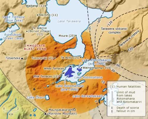
Obliterated in the 1886 Eruption of Mt. Tarawera
Wikipedia article: http://en.wikipedia.org/wiki/Pink_and_White_Terraces
Nearby cities:
Coordinates: 38°15'34"S 176°26'0"E
- Totara Riding 146 km
- Canada Bay Council 2327 km
- "Sandy Island" (Ghost Island) 2664 km
- Willunga Hill Bushfire 13/4/2008 3369 km
- Port Lincoln Fire 23 Dec 2009 3628 km
- Maytown 3992 km
- Maclay house (1871-72, 1876) 4783 km
- Epicenter of Earthquake Situbondo / Oct 11, 2018 (M=6.4) 7032 km
- WILAYAH KEKUASAAN KI AGENG MANGIR WONOBOYO dahulu kala 7408 km
- Kingdom of Srivijaya 8303 km
- Lake Rotomahana 1.2 km
- Lake Tarawera 6 km
- Mount Tarawera 7.7 km
- Lake Rotokakahi 11 km
- Lake Okareka 12 km
- Lake Okataina 15 km
- Okataina 18 km
- Lake Rotorua 24 km
- Lake Rotoiti 25 km
- Mt Ngongotaha Scenic Reserve 27 km