Tacloban City
Philippines /
Eastern Visayas /
Tacloban /
World
/ Philippines
/ Eastern Visayas
/ Tacloban
World / Philippines / Leyte / Macarthur
city, capital city of state/province/region, second-level administrative division, notable by news
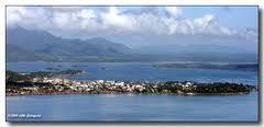
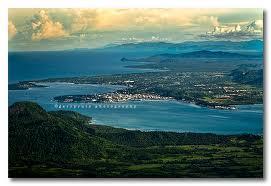

Tacloban (/tækˈloʊbən/ tak-LOH-ban; Tagalog pronunciation: [tɐkˈloban]), officially the City of Tacloban (Waray: Syudad han Tacloban; Filipino: Lungsod ng Tacloban), is a highly urbanized city on Leyte island in the Eastern Visayas region of the Philippines. According to the 2020 census, Tacloban has a population of 251,881, making it the most populous city in the Eastern Visayas. The city is located 360 miles (580 km) southeast of Manila.
Wikipedia article: http://en.wikipedia.org/wiki/Tacloban
Nearby cities:
Coordinates: 11°16'3"N 124°57'46"E
- Borongan 57 km
- Catbalogan Sky City Mega Project (U. C.) 57 km
- Catbalogan City 73 km
- Calbayog City, Philippines 98 km
- Tinambacan Proper - Town Fiesta: May 11 (ATB) 106 km
- Calbayog City 137 km
- Divisoria,Cawayan,Masbate 150 km
- Rapu-rapu 237 km
- Sorsogon City 238 km
- Legazpi City 262 km
- Barangay 100 3.4 km
- Barangay 99 3.5 km
- Barangay 103 3.7 km
- Barangay 91 4.3 km
- Barangay 97 4.3 km
- Barangay 98 5.9 km
- Barangay 106 6.4 km
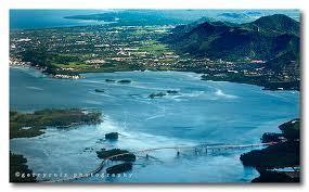
- San Juanico Strait 6.5 km
- map of binongto-an in alangalang leyte 15 km
- Barugo 22 km
Comments