Gorbatka
Armenia /
Tavush /
Dilijan /
World
/ Armenia
/ Tavush
/ Dilijan
mountain, cliff
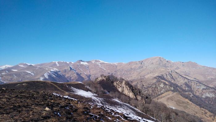
A small elevation of the local relief, a steep cliff, falling to the east. The cliff is clearly visible from many points in the nearby city of Dilijan, and appears as a clearly defined mountain / peak. It is located between Mount Andzavabatsat (2420 m - the end point of the popular Tripeak hiking route) and the Eastern Airikar mountain (2767 m). The cliff does not have an official name due to its little excess over the area to the west. Local residents (Armenians) call this cliff Airikar, although it is not a real peak of the two-headed Airikar (with peaks East Airikar (2767 m) and West Airikar (2781 m)). Among Russian emigrants who settled in Dilijan during the Russian-Ukrainian conflict, the cliff is widely known under the name Gorbatka due to its characteristic shape (Russian: Горбатка — literally Humpy (mountain)).
Nearby cities:
Coordinates: 40°48'28"N 44°48'34"E
- Ariya Volcanic Field 125 km
- Hesaar Mountain 138 km
- Artagers Mountain Range 145 km
- Siyahgan Volcanic Field 146 km
- Yeghbark Sarak mountains 161 km
- Sıra Dağ 168 km
- Vaspurakan mountains 172 km
- Tzaxkants mountains 217 km
- Allahuekber mountains (Karmir Porak) 219 km
- Southern Aras Mountains (Karasu - Aras Dağları) 268 km
- Guzudag mt. 3.8 km
- Kazakh -Bek mt. 13 km
- Dilijan National Park 14 km
- Fidayinneri hovit, Aghbgha, Sultani urt 17 km
- Ijevan district 18 km
- Soyukhbulag mt. 18 km
- Vanadzor district 22 km
- Alaverdi District 28 km
- Noyemberyan disctrict 39 km
- Chambarak District 46 km