Geomundo (Port Hamilton)
Korea (South) /
Chollanam /
Polgyo /
World
/ Korea (South)
/ Chollanam
/ Polgyo
World / South Korea / Jeollanam-do
water, archipelago, invisible


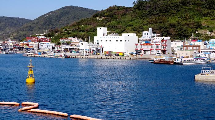


Geomundo, once known as Port Hamilton, is a small group of islands in the Jeju Strait off the southern coast of the Korean Peninsula. Made up of three principal islands, the two larger ones, Sodo to the west, Dongdo to the east, with Godo, the smaller island in the center forming a harbor. The islands, covering 12² km/4.6 mi², are part of the Dadohaehaesang National Park. Most of Geomundo’s facilities are located on Godo.
Geomundo Island's history dates back to the bronze era with the discovery of a stone sword on one of the islands. Subsequent discoveries of coins from the Han Dynasty (206BCE-220CE) used for more than 700 years have also been found. Discoveries of celadon (pottery) from the Goryeo Dynasty (918-1392) have also been located on Geomundo’s islands. Admiral Jeong Yeochang came to Geomundo, was struck by the high literacy level of the Islanders, and had the islands renamed ‘Geomun,’ meaning ‘great literacy’ (do means island).
Port Hamilton was surveyed in 1845 by the British navy and was named after the then secretary of the Admiralty, Captain W. A. B. Hamilton and established a base in 1885. Port Hamilton served as a counterbalance to the Russian naval base at Vladivostok. By occupying Port Hamilton, the British could prevent Russian advances in east Asia, and block Russian naval activity in the Korea Strait.
After the Russian threat had diminished, the British demolished the base in 1887. The British graveyard with ten British soldiers, on Godo, remains to this day and has become a tourist attraction. Ten British sailors and marines are buried on the island, two sailors from HMS Albatross, and a young sailor from HMS Albion.
Godo was only the second place in Korea to have electricity, after the king’s palace in Seoul. Many of the buildings along the harbor date back to the 35 years of Japanese occupation. The architecture of this type has all but disappeared elsewhere in Korea.
Today, the islands form a part of Samsan District, Yeosu City, South Jeolla Province, with the Samsan District offices located on Observation Island. The islands are also part of the Dadohae Haesang National Park.
Wikipedia article: http://en.wikipedia.org/wiki/Port_Hamilton
Nearby cities:
Coordinates: 34°1'47"N 127°18'19"E
- Toshima 473 km
- Yaeyama Islands 1129 km
- Batanes 1519 km
- Babuyan Islands 1714 km
- Lesser Kuril Chain 1938 km
- Calamian Islands 2527 km
- Middle Kurils 2557 km
- Commander Islands 3781 km
- The Andaman and Nicobar Islands Territory (India) 4183 km
- Nicobar Islands 4484 km
- Sodo 0.7 km
- Geomundo Inner Harbor 1.1 km
- Geomundo Godo 1.1 km
- Sunhodo 2.4 km
- Daemsambudo 8.5 km
- Yokmando 17 km
- Sangbaekdo 26 km
- Pyeongdo (평도) 27 km
- Sonjukdo (손죽도) 28 km
- Sogeomondo 30 km