Santa
Turkey /
Trabzon /
Macka /
World
/ Turkey
/ Trabzon
/ Macka
valley, village, archeological site, historic site


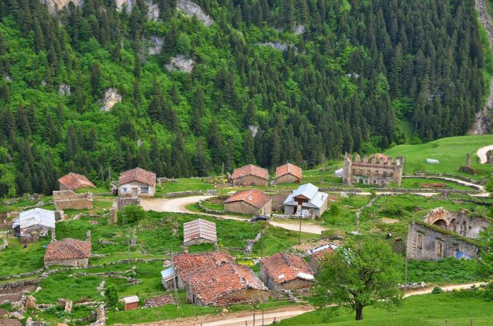
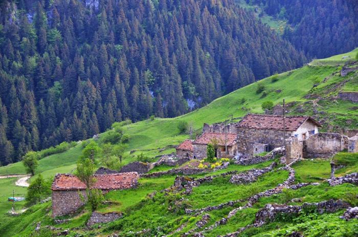


SANTA RUINS & VALLEY
Located within the borders of Dumanlı Village in the central district, Santa is 72 km from the city center. From the main tour route, following the Yayladere Village road in the direction of the central district Arzular Town, passing Kosdan Mountain, you can reach Taşköprü Plateau and then Santa.
The settlement, which was founded by the Greeks in the 17th century, is important in terms of religion, trade and culture, but it is known that it was also used as a shelter by the Greek gangs. Santa, which is an "Archaeological and Natural Site" today; It consists of seven neighborhoods, "Binatlı, Terzili, Zurnacili, Piştovlu, İşhanlı, Çinganli, Çakallı" and more than three hundred houses. There are single-storey houses and at least one church built entirely of stone in every neighborhood of the city, and a fountain in every street.
official/source: www.gumushane.bel.tr/gumushane-rehberi/turizm
°°°°°°°°°°°°°°°°°°°°°°°°°°°°°°°°°°°°°°°°°°°°
The historical Santa mining town and the ruins of Santa that have survived from this settlement consist of the Dumanlı village and neighborhoods of the central district of Gümüşhane. Santa (Dumanlı Village), which was a mining village settlement during the Ottoman period, is located in the Yanbolu valley and 47 km inland from the coast at an average altitude of 1,600 meters.
There were 7 settlements as a neighborhood in Santa, which was built on 3 separate slopes separated by valleys, where Yanbolu Stream originates and where you can see each other very clearly from a bird's eye view. These neighborhoods and their 19th century populations are as follows;
• Piştoflu (Pistofanton: 300 households)
• Binatlı (Pinatanton: 60 houses)
• İshanlı (Ischananton: 260 households)
• Terzili (Terzanton: 200 households)
• Çakallı (Tsakalanton: 53 households)
• Zurnacılı (Zournatsanton: 120 households)
• Sincanlı-Kozlu (Kozlaranton: 60 households)
RELIGIOUS BUILDINGS
• Piştoflu: Churches of St. Kyriake + St. Panteleimonos + St. Christophoros
• Zurnacılı: Churches of St. Georgios + St. Constantine + St. Kyriake
• Çakallı: Zodoxu Rigis + St. Georgios churches
• Iskhanli: Churches of St. Kyriake + St. Georgios
• Kozlu-sincanli: Holy Apostol Petro + Apostol Pavio churches
• Binatlı: Churches of Profizitic Ilion + St. Georgios
• Terzili: Churches of Hagia Theodoros + Metamorphosis
Nearby cities:
Coordinates: 40°39'41"N 39°48'10"E
- Krom 23 km
- Arshakavan 381 km
- Gaugamela Battlefield 546 km
- Battle of the Granicus River 1061 km
- Amfissa Olive Grove 1511 km
- Amfissa 1511 km
- Geraki (Falcon) 1536 km
- Battle of Navarino 1623 km
- Navarino (Pylos) bay 1624 km
- Tuti Island 2874 km
- Piştoflu 1 km
- Ziyaret (2800 m) 5.2 km
- Araklı District 15 km
- Trabzon Province 17 km
- Maçka District 24 km
- Köprübaşı District 26 km
- Sürmene District 31 km
- Aydıntepe District 36 km
- Gümüşhane Province 47 km
- Bayburt Province 57 km