Sierra Estrella Mountains
USA /
Arizona /
Goodyear /
World
/ USA
/ Arizona
/ Goodyear
World / United States / Arizona
draw only border, mountain range

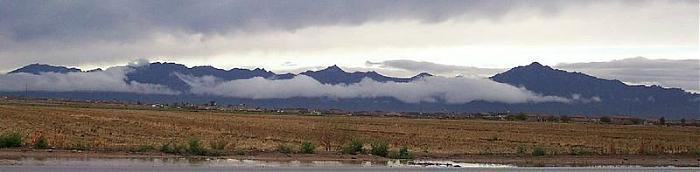
The Sierra Estrella (elevation 4354 ft.) is a mountain range located southwest of Phoenix, Arizona. Much of the range falls within the Gila River Indian Reservaion, but 11,400 acres of BLM land is now the Sierra Estrella Wilderness.
One of the highest peaks was named for a humble warrior, the late Ira Hayes; the United States Marine who helped raise the U.S. flag on Mount Sirubachi on the island Iwo Jima in World War II.
The mountain range offers fantastic views and great weather. Visiting the Estrellas is ideal to escape the desert heat. On the highest peaks, temperatures are usually 8-12 degrees cooler than what is seen in the valley. Snow can be seen at least once or twice a year on the highest points of the mountain range (typically above 4,000 ft). Sometimes, the snow level can drop near 2,000 ft, but depends if the precipitation reaches the mountain range. A good example is during the month of March 2006, when a heavy storm system reached the state and lowered snow levels near 4,000 ft. Once the skies cleared next morning, snow covered the Estrella's mountain tops.
Wikipedia article: http://en.wikipedia.org/wiki/Sierra_Estrella
Nearby cities:
Coordinates: 33°14'6"N 112°17'4"W
- Chocolate Mountains 320 km
- Panamint Range 597 km
- Guadalupe Mountains 672 km
- San Juan Mountains 674 km
- Grant Mountain Range 687 km
- Sangre de Cristo Mountain Range 809 km
- Wind River Range 1139 km
- Bighorn Mountains 1353 km
- Jbel Bani 9401 km
- Kereb Al Hamada 9421 km
- District 7: Maricopa Colony 10 km
- Estrella Mountain Regional Park 13 km
- Estrella 15 km
- District 6: Komatke 17 km
- Laveen Village 18 km
- South Mountain Park 23 km
- Estrella Village 23 km
- Gila River Indian Reservation 35 km
- Sonoran Desert National Monument 37 km
- Phoenix, Arizona 44 km