Dang La - Tanggula Pass (5.234 m)
China /
Xizang /
Lasa /
World
/ China
/ Xizang
/ Lasa
World / People's Republic of China / Qinghai / Gyêgu Tibetan
mountain pass
Add category
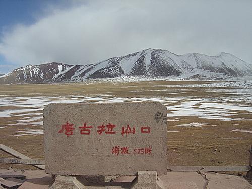

The Tanggula Pass is a mountain pass that rises to over 5000 meters above sea level. The Qinghai–Tibet Highway reaches its highest point of 5.234 meters here.
Wikipedia article: http://en.wikipedia.org/wiki/Tanggula_Pass
Nearby cities:
Coordinates: 32°53'0"N 91°55'8"E
- Gyen La 296 km
- Trorang La 471 km
- Zhabu La (pass) 530 km
- Jammu Pass 530 km
- Yonggyap La 545 km
- Andzamkho La 556 km
- Chaukan Pass 816 km
- Lazikou Pass 1119 km
- Đèo Ô Quy Hồ (Đèo Hoàng Liên Sơn) 1652 km
- Ma Phuc mountain pass 1811 km
- Tanggula Mountains 96 km
- Tso Nag 104 km
- Chöma Tso 130 km
- Zige Tangco 134 km
- Mardrang Tsochen 166 km
- Migriggyangzham Co 171 km
- Chibuzhangcuo pliocene-quaternary lava fields 173 km
- Khyeshang Tso 189 km
- Nortor Tso 202 km
- Balab Tso 222 km
Comments