Rame Head
United Kingdom /
England /
Torpoint /
World
/ United Kingdom
/ England
/ Torpoint
World / United Kingdom / England
headland (geography)
Add category
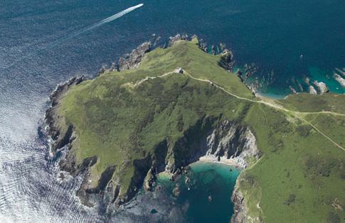
Rame Head is a coastal headland, southwest of the village of Rame in southeast Cornwall, United Kingdom. aside from the coastguard lookout there is a well-preserved Iron Age hill fort on the peninsula. There was once a medieval chapel based here, and crumbling ruins of the building can still be seen.
Wikipedia article: http://en.wikipedia.org/wiki/Rame_Head
Nearby cities:
Coordinates: 50°18'48"N 4°13'23"W
- Start Point 41 km
- Portland Bill 127 km
- Hengistbury Head 179 km
- Abermenai Point 315 km
- The Great Orme / Y Gogarth 338 km
- Muntevary or Sheep´s Head (Rinn Mhuintir Bháire) 418 km
- Crow Head 440 km
- Flamborough Head 508 km
- Benmore / Fair Head 562 km
- Mull of Kintyre 570 km
- Whitsand Bay Holiday Park 3.3 km
- Whitsand Bay 3.7 km
- Tregantle Beach 6.1 km
- The Rosehill (Wreck) 6.4 km
- HMS Raleigh 6.6 km
- HMS Scylla (Wreck) 7.2 km
- Whitsand Bay Hotel Golf Course 7.8 km
- Antony House 8.1 km
- Sheviock 8.3 km
- Cornwall 53 km