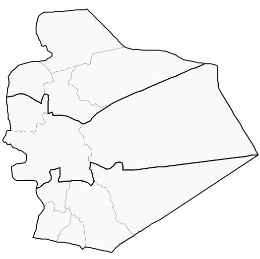
As-Suwayda Governorate (PCS)
Syria /
as-Suwayda /
Sahaba /
World
/ Syria
/ as-Suwayda
/ Sahaba
, 31 km from center (شهبا)
first-level administrative division, draw only border, governorate (administrative division), do not draw title

People council of Syria governed part of As-Suwayda Governorate
Arabic: السويداء
Seat: As-Suwayda
Area: 5,550 km² (estimated)
Population: 770,000 (2011 estimate)
ISO 3166-code: SY-SU
As-Suwayda Governorate is one of the fourteen governorates of Syria. The governorate is divided into 3 districts and 12 subdistricts.
Arabic: السويداء
Seat: As-Suwayda
Area: 5,550 km² (estimated)
Population: 770,000 (2011 estimate)
ISO 3166-code: SY-SU
As-Suwayda Governorate is one of the fourteen governorates of Syria. The governorate is divided into 3 districts and 12 subdistricts.
Wikipedia article: https://en.wikipedia.org/wiki/As-Suwayda_Governorate
Nearby cities:
Coordinates: 32°45'10"N 36°54'6"E
- Rif Dimashq Governorate 194 km
- Homs Governorate (PCS) 303 km
- Anbar Governorate (ICR) 320 km
- ِAlNajaf AlAshraf Province 580 km
- Salah Al-Deen Governorate 609 km
- Nineveh Governorate (ICR) 612 km
- Al Muthana Province 660 km
- Basra Province 922 km
- Hadhramaut Governorate 1799 km
- Al-Mahrah Governorate 2040 km
- Khirbet ad-Diyathiyah 5.6 km
- Umm ar-Ruwaq 12 km
- Tar al-Hdeijeh 14 km
- Tell Hzeimeh 15 km
- al-Qat'i 17 km
- Al-Mushannaf Subdistrict (PCS) 17 km
- al-Arab Mountain 21 km
- Shaqqa Subdistrict 22 km
- Shahba Subdistrict (Nahiyah) 26 km
- Markaz As-Suwayda Subdistrict 34 km