Eastern end point of the survey base line of the Bukovina cadastral datum.
Romania /
Suceava /
Radauti /
World
/ Romania
/ Suceava
/ Radauti
place with historical importance, interesting place
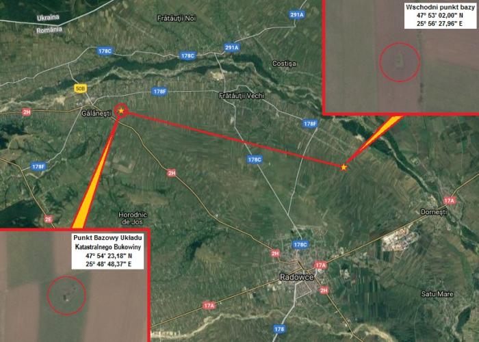
In the XIX centur, at the area of Austrian Empire (from 1867, Autria-Hungary) has run eight coordinate systems used in the real estate cadastral land surveing. Each cadastral datum has a basic point, which geographic coordinates were very precise astronomicaly determined. The smallest one was the 'Bukovina datum' which comprised the area of Bukovina Dutchy, now lying at the terytory of Romania and Ukraine. Its basic point was the western end of base line, north form the city of Rădăuți in Romania; in Gălăneşti town stands a monument which marks this point. The eastern point of the base line is marked by small stone located at the flat mound.
Nearby cities:
Coordinates: 47°53'2"N 25°56'27"E
- Trains running at the Southern bank of the street 4.3 km
- Basic point of the Bucovina cadastral datum 10 km
- Suceviţa Monastery 21 km
- Suceava 26 km
- Suceava North railway station 31 km
- Manastirea Sfantul Ioan cel Nou 36 km
- Voronet Monastery 41 km
- Crash site a polish aircraft PLL "LOT" Lockheed L-14H - 22 July 1938 45 km
- Comuna Baia 54 km
- Old city center 56 km
- HS Timber Productions S.R.L./Sawmill Rădăuți 3.8 km
- Egger România 4.1 km
- Iaz(Dorneşti) 4.1 km
- Amenajare Complexa Arbore-Marginea Volovat 12 km
- Marginea 13 km
- Lunca(Milişăuţi) 15 km
- Voivodeasa (Fursenthal) 18 km
- Bivolărie 21 km
- Hlyboka Raion 24 km
- Storozhynets Raion 34 km