ATTO
Brazil /
Amazonas /
Rio Preto da Eva /
World
/ Brazil
/ Amazonas
/ Rio Preto da Eva
tower, observatory, research
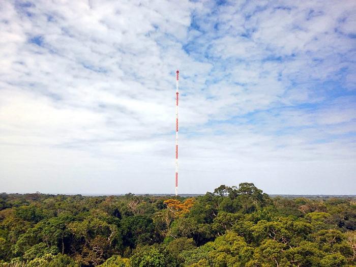
ATTO stands for Amazon Tall Tower Observatory. Its co-ordinates -2.145895S, -59.005578W.
This is joint project of Germany-Brazil and is coordinated by the Max Planck Institute for Chemistry. to study climate models. It is 300 meters tall and will give information of about 100 squarekilometers from the world´s largest forest area.
This is joint project of Germany-Brazil and is coordinated by the Max Planck Institute for Chemistry. to study climate models. It is 300 meters tall and will give information of about 100 squarekilometers from the world´s largest forest area.
Nearby cities:
Coordinates: 2°8'45"S 59°0'20"W
- Radio Clube do Para transmitter (Mediumwave) 1181 km
- Tower 1289 km
- Torre de Alta Tensão 1801 km
- Tower 1908 km
- Tower 1919 km
- SBT Tower 1932 km
- Brasilia TV Tower 1947 km
- Tower 1951 km
- Tower 2263 km
- Tower 2566 km
- Cemetery 145 km
- Parintins 241 km
- Runway 06/32 255 km
- Cultural Center Amazonino Mendes - Bumbódromo 258 km
- City Cemetery 258 km
- Zona Azul - Boi Bumbá Caprichoso 259 km
- Trombetas River Camping 279 km
- CAMPO DO JUVENIL 279 km
- Porto Trombetas 289 km
- T.Q MOCAMBO 303 km