Village Lock-Up (Breedon on the Hill)
United Kingdom /
England /
Melbourne /
Breedon on the Hill /
Main Street
World
/ United Kingdom
/ England
/ Melbourne
village lock-up / calaboose
Add category

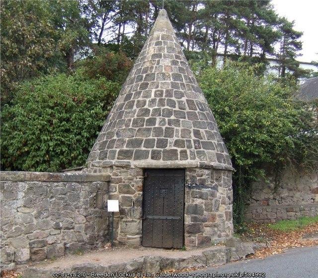
18th-century. Stout door, no windows, and – because tiles or shingles might be removed from inside by an inmate eager to climb out – a solid stone roof. The adjoining wall is part of a secure enclosure or pound/Pinfold, in Medieval Britain, is an area where stray animals were rounded up if their owners failed to properly supervise their use of common grazing land. A mulct (fine) had to be paid for their release. -Geograph.
Photos:
1) www.geograph.org.uk/photo/2605953
2) www.geograph.org.uk/photo/584992
Photos:
1) www.geograph.org.uk/photo/2605953
2) www.geograph.org.uk/photo/584992
Wikipedia article: https://en.wikipedia.org/wiki/Breedon_on_the_Hill
Nearby cities:
Coordinates: 52°48'7"N 1°23'53"W
- The Old Town Lock Up 70 km
- The Old Village Lock-up 119 km
- Prince Rupert's Tower 125 km
- The Village Lock Up 130 km
- Old Parish Village Watchman's Hut & Lock-Up 169 km
- Pensford village lock-up 178 km
- Village Lock-up 184 km
- The Guard House 190 km
- Parc des Oliviers 1201 km
- Jail 6331 km
- Blackbrook Reservoir 7.7 km
- Longcliffe Golf Course 10 km
- The National Forest 10 km
- Bardon Hill Quarry 11 km
- Sense Valley Park 12 km
- Ibstock West 12 km
- Loughborough University 12 km
- Bardon Industrial Estate 12 km
- Outwoods 13 km
- Bradgate Park 17 km